Tag: ASTER

ASTER News and Events

antikythera_ast_2013266

NASA Earth Observatory image by Jesse Allen, using data from NASA/GSFC/METI/ERSDAC/JAROS, and U.S./Japan ASTER Science Team. Caption by Kathryn Hansen.

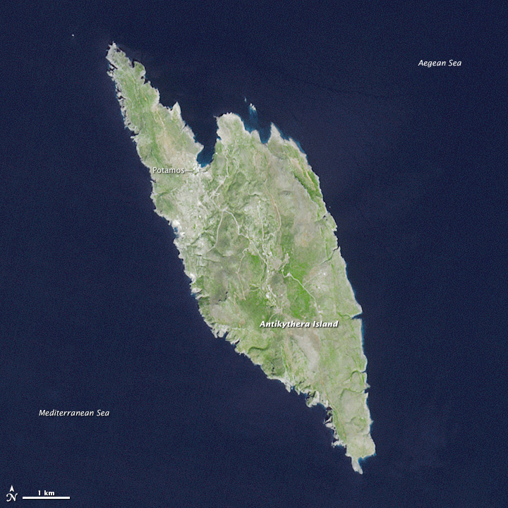
Crete is the largest and most populous Greek island, spanning 8,300 square kilometers (3,200 square miles) and supporting a population of 620,000. A short distance northwest of Crete is a lesser-known Greek island, Antikythera. The island is comparatively tiny, spanning just 20 square kilometers (8 square miles) and supporting a human population that hovers around 50.

This view of Antikythera was acquired on September 23, 2013, by the Advanced Spaceborne Thermal Emission and Reflection Radiometer (ASTER) on the Terra satellite. The landscape is typical of a small Mediterranean island, consisting primarily of open countryside and low shrubs. Steep, limestone cliffs line most of the island; flatter expanses of beach are more common on Kythira, a larger Greek island to the north. Read more

wolf_ast_2015162

NASA Earth Observatory image by Jesse Allen, using data from NASA/GSFC/METI/ERSDAC/JAROS, and U.S./Japan ASTER Science Team. Caption by Mike Carlowicz.

In late May 2015, the highest volcano in the Galapagos Islands erupted for the first time in 33 years. The explosive eruption at Wolf volcano on Isabela Island sent volcanic gases and ash roughly 15 kilometers (50,000 feet) into the sky, while lava flowed through a fissure, down eastern and southeastern slopes, and eventually reached the sea. In early June, the sulfur-rich lava flows on the slopes appeared to subside.

The wide image and closeup of Wolf was acquired on June 11, 2015, by the Advanced Spaceborne Thermal Emission and Reflection Radiometer (ASTER) on the Terra satellite. The false-color images combine near-infrared, red, and green light (ASTER bands 3-2-1), with vegetated areas appearing in red and lava generally appearing charcoal or black. Note, however, the infrared (IR) image on the top right, where the heat signature of the freshly placed lava appears as white streaks. (The image is smaller because the sensor has lower resolution.) Read more

shasta_ast_2014245

NASA Earth Observatory images by Joshua Stevens, using data from NASA/GSFC/METI/ERSDAC/JAROS, and U.S./Japan ASTER Science Team. Caption by Kathryn Hansen.

The ongoing drought in the western United States is evident in the water levels of Shasta Lake, a large reservoir in northern California that counts on rainfall for replenishment. Low water levels can lead to hazardous conditions for local recreation. Many more people are affected by how this limited water resource is allocated for ecological, urban, and agricultural needs downstream.

The Advanced Spaceborne Thermal Emission and Reflection Radiometer (ASTER) on Terra acquired these simulated true-color images of Shasta Lake. The top image shows the lake on September 14, 2005, and the bottom image was acquired on September 2, 2014. Read more

NASA Earth Observatory image (top) by Joshua Stevens using Landsat data from the U.S. Geological Survey and ASTER GDEM2 data from NASA/MITI and the ASTER Science Team.

NASA Earth Observatory image (top) by Joshua Stevens using Landsat data from the U.S. Geological Survey and ASTER GDEM2 data from NASA/MITI and the ASTER Science Team.

At approximately 6:45 a.m. on April 18, 2014, a block of ice tumbled from the edge of a hanging glacier onto a popular climbing route on the south face of Mount Everest. The ice, which weighed as much as 657 passenger buses, tumbled about 400 meters (1,300 feet) and triggered an avalanche. The falling ice and rock overwhelmed a group of Nepalese guides who were ferrying equipment from Base Camp (elevation 5,270 meters) to Camp 1 (elevation 6,035 meters) for foreign clients. Sixteen guides died in the avalanche, making it Everest’s deadliest day.

This three-dimensional rendering—made with data collected by the Operational Land Imager on Landsat 8 and the Advanced Spaceborne Thermal Emission and Reflection Radiometer (ASTER) on Terra—offers a broad view of the topography that climbers face. Read More

ASTER_first_An_v2Fifteen years ago this month the Advanced Spaceborne Thermal Emission and Reflection Radiometer (ASTER) sensor onboard NASA’s Terra satellite began returning images. The first image from ASTER’s thermal infrared (TIR) subsystem was captured on March 3, 2000 of the western edge of the volcanic Afar Triangle in Ethiopia (see image to the right). This image represents not only ASTER’s first thermal image, but also the first high resolution multispectral thermal data collected by a sensor on a satellite. Since this first image 15 years ago, ASTER data has continued to be valuable to geologic and volcanic applications, as well as many other scientific disciplines.

Read the full article