

Advanced Spaceborne Thermal Emission and Reflection Radiometer
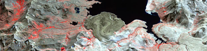
This perspective image of a complex volcanic landscape in the Andean mountain range was assembled from data acquired by ASTER on April 9, 2003. ASTER produces images using infrared, red, and green wavelengths of light. Vegetated areas range in color from red to pink, snow is white, water is black, and bare rock is earth-toned.
The Advanced Spaceborne Thermal Emission and Reflection Radiometer obtains high-resolution (15 to 90 square meters per pixel) images of the Earth in 14 different wavelengths of the electromagnetic spectrum, ranging from visible to thermal infrared light. Scientists use ASTER data to create detailed maps of land surface temperature, emissivity, reflectance, and elevation.
ASTER is the only high spatial resolution instrument on the Terra platform. ASTER’s ability to serve as a ‘zoom’ lens for the other Terra instruments is particularly important for change detection, calibration/validation and land surface studies. Unlike the other instruments aboard Terra, ASTER will not collect data continuously; rather, it collects an average of 8 minutes of data per orbit. All three ASTER telescopes (VNIR, SWIR, and TIR) are pointable in the crosstrack direction. Given its high resolution and its ability to change viewing angles, ASTER produces stereoscopic images and detailed terrain height models.
The ASTER instrument was built in Japan for the Ministry of Economy, Trade and Industry (METI). A joint United States/Japan Science Team is responsible for instrument design, calibration, and data validation.
ASTER Web Site (Jet Propulsion Laboratory)