Tag: ASTER

ASTER News and Events

Terra Operational Changes and Data Updates

Over the past three years, the Terra mission has performed multiple maneuvers that have led to changes in the satellite’s consistent 20+ year orbit*. Today, Terra continues slowly drifting to an increasingly earlier overpass time and lower altitude. While the orbital changes have had little to no impact on instrument data collection or quality, data users have expressed the need for regular updates on Terra’s equator crossing time (in Mean Local Time), as well as orbital altitude. Starting this month, we’ll be adding this information to the Terra homepage and updating it bi-weekly using data provided by the Flight Dynamics Team.

Finally, processing of ASTER data has re-started, with updated Level-1processing to account for the lower Terra orbit. Processing of the previously-collected data since late October 2022 to the end of June 2023 is also taking place. See the infographic provided on the Terra website for more information, and for the latest news on all things related to Terra data, visit the Alerts and Issues page available on the LAADS DAAC website (linked here).

*For more information about Terra’s orbit changes, check out the January/February 2023 edition of The Earth Observer — linked here — for summaries of two recent NASA-hosted webinars pertaining to these changes, or visit the Terra website.

Terra Instrument Check-In

Here’s a list of 2023 happenings and publications for each Terra instrument:

ASTER:

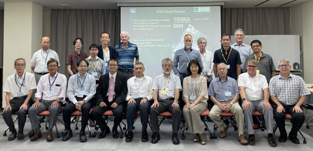
The 52nd ASTER Science & Interface Meeting was held at the Kikai Shinko Kaikan in Minato-ku, Tokyo, Japan from September 11-15, 2023 (group photo posted below). The meeting included two Plenary sessions, as well as presentations from ASTER working groups, including Operations and Mission Planning (OMP), Applications, Calibration and Validation, Temperature-Emissivity Separation (TES), and the Science Team Acquisition Request (STAR) groups. Meeting presentations showcased diverse applications of ASTER data in various fields and activities, including mineral and other geologic mapping projects, coastal monitoring activities, cryospheric studies, machine learning models for urban land dynamics, and volcanic eruption precursor detection. Additionally, updates were provided on the ASTER Volcano Archive and the Global Land Ice Measurements from Space (GLIMS) Database. A copy of meeting presentations are available upon request.

Photo credit: Mako Komoda, Japan Space Systems

CERES:

The next CERES meeting will be held in-person from October 17-19, 2023 at NASA Goddard Institute for Space Studies, in New York City, NY. See the “Meeting Logistics and Recommended Hotels” link on the CERES website for more information about attending the meeting and a link to the full agenda (also linked here). Many exciting speakers are scheduled to speak at the meeting, so check back to the Terra website often for an update and summary after the meeting!

MISR:

The MISR team has been working hard on algorithm adjustments needed to finalize the Level-1 data processing take into account the effects of Terra’s orbit lowering in October 2022. Additional updates on the status of this process will be posted on the Terra website, including a notice when processing has begun.

MISR was highlighted during a biannual summer workshop, hosted by NASA Disasters program, to support dialogue and collaboration between NASA experts and members of the Volcanic Ash Advisory Centers (VAACs) team. Find out more about this partnership in a recently-published story from the Disasters program, linked here!

MODIS & MOPITT:

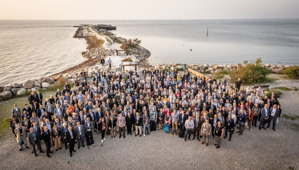
Miguel Román (MODIS) and Helen Wooden (MOPITT) both attended the European Organisation for the Exploitation of Meteorological Satellites (EUMETSAT) Meteorological Satellite Conference 2023 that took place in Malmö, Sweden, from September 11-15, 2023. A (beautiful) group photo from the meeting is included below.

Miguel Román participated in several sessions to discuss EUMETSAT’s plans for morning-orbit polar orbiting observations. As recommended by NASA’s Terra, Aqua, and Aura Data Continuity Workshop, the EUMESAT Multispectral Visible Infrared Imager (METImage) on the Metop-SG A satellite, due to launch in December 2024, is being explored as a possible source of morning data product continuity, currently represented by the suite of standard science products generated from the MODIS instrument onboard Terra.

Helen Worden presented trends using the MOPITT data record of global carbon monoxide (CO) and plans for continuation of the MOPITT record using MetOP/IASI, NOAA/CrIS and ESA/TROPOMI data. The MOPITT team has long collaborated with the EUMETSAT IASI instrument team on satellite data inter-comparisons. Comparisons with MOPITT data have been especially important for new instruments in space, since MOPITT has the longest available record of satellite CO observations. The EUMETSAT meeting had many useful presentations on atmospheric composition and trends, among other interesting topics, with plenty of networking opportunities for developing new ideas for research and plans for data continuity.

Photo Credit: EUMETSAT

Printed Wire Assemblies Back Online

To return function to 16 printed wire assemblies, including the two most recent, Terra’s Flight Operations Team rebooted Terra’s solid state recorder, on September 22, 2021. The successful reboot of Terra’s solid state recorder returned Terra to a level that allows full science acquisitions from all five instruments (ASTER, CERES, MISR, MODIS, and MOPITT). 

The recorder reboot took nearly 12 hours to complete. The board-by-board power up sequencing resulted in all 16 printed wire assemblies of the 16 offline assemblies returning to operational status.  Terra now has all 58 assemblies in service, and Terra’s data storage capacity is at the same level it had at launch. There are currently no known hardware limitations to the operation of Terra or any of its sensors and there is currently no official passivation (mission end) date. 

For over two decades Terra has collected valuable data about Earth’s systems. In February 2020 Terra stopped doing platform maneuvers that would control its equator crossing time in order to maintain fuel for collision avoidance maneuvers. The remaining fuel will also be used to lower Terra’s orbit as part of its eventual passivation process.  Now with the printed wire assemblies being returned to full function, Terra will be able to collect full data acquisitions from all five instruments throughout this process.

Terra will also continue collecting data after an orbit lowering maneuver planned for Fall 2022. The maneuver upholds agreements to ensure Terra is a safe distance from the other missions in the 705-km Earth Observing Satellite Constellation when fuel to maintain Terra’s orbit has been depleted.

“The science community views the changes in crossing time and orbit altitude as continuation of normal data collection for those products not affected by the orbital changes as well as an opportunity to do novel science with those that are affected,” according to Kurtis Thome, Terra Project Scientist.  The Terra Project fully expects the Terra platform and all five instruments to operate past 2026 allowing them to maintain their status as leaders in Earth science data production.  Terra’s long-term data record will continue to contribute to the Earth Science Division’s key science questions:

  • How is the global Earth system changing?
  • What causes these changes in the Earth system?
  • How will the Earth system change in the future?
  • How can Earth system science provide societal benefit?

Terra, the flagship Earth Observing Satellite, continues to be a leader in Earth science data, contributing to scientific research and applications worldwide, now with data capacity levels restored by a successful solid state recorder reboot.

Bighorn Fire north of Tucson, Arizona, on June 29
NASA’s Advanced Spaceborne Thermal Emission and Reflection Radiometer (ASTER) instrument imaged areas burned by the Bighorn Fire north of Tucson, Arizona, on June 29. Vegetation is shown in red and burned areas are shown in dark gray. It covers an area of 20 by 30 miles (33 by 48 kilometers). Credit: NASA/JPL-Caltech
› Larger view

From the vantage point of the Terra satellite, the instrument can detect the scarred land that the wildfire, burning north of Tucson, is leaving in its wake.


On the night of June 5, a lightning strike started the Bighorn Fire in the Santa Catalina Mountains north of Tucson, Arizona. Extremely dry vegetation and windy conditions caused the fire to spread quickly. By June 30, the multi-agency incident information system, InciWeb, reported that it had ballooned to more than 114,000 acres and that it was about 45% contained.

NASA’s Advanced Spaceborne Thermal Emission and Reflection Radiometer (ASTER) instrument aboard the Terra satellite imaged some of the burned area on June 29. In this image, vegetation is shown in red and burned areas appear dark gray. It covers an area 20 by 30 miles (33 by 48 kilometers).

Efforts to contain the fire continue with 21 hand crews, 10 helicopters and dozens of fire engines deployed to the area. Smoke impacts to surrounding communities are being carefully monitored.

With its 14 spectral bands from the visible to the thermal infrared wavelength region and its high spatial resolution of about 50 to 300 feet (15 to 91 meters), ASTER images Earth to map and monitor the changing surface of our planet. It is one of five Earth-observing instruments launched Dec. 18, 1999, on Terra. The instrument was built by Japan’s Ministry of Economy, Trade and Industry. A joint U.S./Japan science team is responsible for validation and calibration of the instrument and data products.

The broad spectral coverage and high spectral resolution of ASTER provides scientists in numerous disciplines with critical information for surface mapping and monitoring of dynamic conditions and temporal change. Example applications are monitoring glacial advances and retreats; monitoring potentially active volcanoes; identifying crop stress; determining cloud morphology and physical properties; wetlands evaluation; thermal pollution monitoring; coral reef degradation; surface temperature mapping of soils and geology; and measuring surface heat balance.

The U.S. science team is located at NASA’s Jet Propulsion Laboratory in Southern California. The Terra mission is part of NASA’s Science Mission Directorate, Washington.

This story originally appeared on https://www.jpl.nasa.gov

News Media Contact

Ian J. O’Neill / Jane J. Lee
Jet Propulsion Laboratory, Pasadena, Calif.
818-354-2649 / 818-354-0307
ian.j.oneill@jpl.nasa.gov / jane.j.lee@jpl.nasa.gov
Written by Esprit Smith, NASA’s Earth Science News Team

When volcanoes erupt, ASTER turns its attention to documenting the changes to the landscape as they happen. ASTER is uniquely capable of turning to see areas where volcanoes are erupting in very high resolution (between 15 in the thermal bands – 90 meter spatial resolution in the visible light spectral bands).

As Hawaii’s Kilauea continues to erupt, ASTER continues to monitor the eruption from space. This image from May 6, 2018 shows the sulfur dioxide being released from the volcano in yellow and yellow-green.

Read more:

Satellite View of Kilauea Eruption from NASA JPL


timor_tmo_2016197

Cloud Streets over Timor Sea

July 24, 2016

These “streets of the sky” called cloud streets are long parallel bands of cumulus clouds. On July 15, 2016, the Moderate Resolution Imaging Spectroradiometer (MODIS) on NASA’s Terra satellite aquired these images of cloud streets off the northern coast of Australia. Read more on NASA’s Earth Observatory.


labrador_mod_2016184

Swirls of Ice in the Labrador Sea

July 21, 2016

What first appeared to be a storm wasn’t a low pressure system in the clouds, but a swirling mass of ice in the sea. The Moderate Resolution Imaging Spectroradiometer (MODIS) on NASA’s Terra and Aqua satellites acquired views of an ice eddy off the coast of Labrador, Canada, on July 2, 2016. Read more on NASA’s Earth Observatory.


gypsymoth_tmo_2016178

Caterpillars Take Bite Out of Rhode Island Forests

July 15, 2016

Gypsy moth caterpillars damaged parts of New England’s forests and the damage is extensive enough to be seen from space. The Moderate Imaging Spectroradiomenter on NASA’s Terra satellite captured images of the damage over Rhode Island, Massachussetts and Connecticut during the pests’ population boom in the summer of 2016. Read more on  NASA’s Earth Observatory.


namibia_tmo_2016178

Making Waves in the Sky off of Africa

July 14 , 2016

On June 26, 2016, the Moderate Resolution Imaging Spectroradiometer (MODIS) on NASA’s Terra satellite acquired this natural-color image of cloud gravity waves off the coast of Angola and Namibia. Learn more about this phenomenon on NASA’s Earth Observatory.


chile_tmo_2016190

Unusual Dust Off of Chile

July 12, 2016

Large amounts of dust were airborne off the west coast of South America. This is not a typical location dust events such as this one. The Moderate Resolution Imaging Spectroradiometer (MODIS) on NASA’s Terra satellite acquired this image of airborne dust off the coast of Chile, on July 8, 2016. Read more on NASA’s Earth Observatory.


sherpafire_ast_2016171

Studying the Sherpa Fire

July 2, 2016

The Sherpa fire west of Santa Barbara, California was contained before it caused damage to homes or infrastructure. However, it still charred several thousand acres as of June 29. The Advanced Spaceborne Thermal Emission and Reflection Radiometer (ASTER) on the Terra satellite acquired an image of the burn scar on June 19, 2016. Read more on NASA’s Earth Observatory.