Tag: ASTER

ASTER News and Events

caspiansea_amo_2016158

Does Dust Affect Water Levels of the Caspian Sea

June 10, 2016

Dust storms over the Caspian Sea lead to increased evaporation and a drop in lake level according to new research using observations of dust collected by instruments on several satellites including the Moderate Imaging Spectroradiometer (MODIS ) and the Multi-angle Imaging Spectroradiometer (MISR) on Terra.


ruapehu_ast_2016111

A Satellite Eye on Mount Ruapehu

June 5, 2010

Mount Ruapehu is one of New Zealand’s most active volcanoes and most visited, dotted with skiers and snowboarders along its slopes.  When it erupts lahars, flows of volcanic debris and sediment, can have devastating impacts, prompting geologists to regularly monitor the volcano, using the Advanced Spaceborne Thermal Emission and Reflection Radiometer on NASA’s Terra satellite.


April 26, 2016

A Sudden Color Change on Lake KivuThe Moderate Imaging Spectroradiometer (MODIS) on NASA’s Terra Satellite captured images of a whiting event in Lake Kivu. The seasonal event is stronger this year, giving Lake Kivu a milky color. 


April 22, 2016

Using Clouds to Map Life – A team of researchers are using cloud data from the Moderate Imaging Spectroradiometer (MODIS) on NASA’s Terra Satellite to create detailed maps of cloud cover and variability. The team found that cloud cover could be an indicator and a better predictor of a songbird and flower’s range than temperature and precipitation.


April 17, 2016

Yellowstone National Park – Learn about Yellowstone National Park and view an image made possible by the Digital Elevation Model from the Advanced Spaceborne Thermal Emission and Reflection Radiometer (ASTER) on NASA’s Terra satellite.


April 14, 2016

Sierra Nevada Snowpack is Better, But not Normal – Snowpack in the Sierra Nevada mountains dwindled over recent years; however, the winter of 2015-2016 and the strong El Nino provided a thicker and more extensive snowpack. Regardless, snow levels in the Sierra Nevada mountains were still below average. Images from NASA’s Moderate Imaging Spectroradiometer (MODIS) clearly show the difference between years.


April 13, 2016

Antarctic Ice Shelf Sheds Bergs – The Moderate Imaging Spectroradiometer on NASA’s Terra Satellite captured this striking image of the formation of two new icebergs as they broke away from the Nansen Ice Shelf into the Southern Ocean on April 7, 2016.


April 9, 2016

Greening Ascension Island – When Charles Darwin first visited Ascension Island it was barren, but with the assistance of Joseph Hooker in the 1800s plants were introduced and now cover much of this once bleak island. The image from the Advanced Spaceborne Thermal Emissions and Reflection Radiometer (ASTER) on NASA’s Terra satellite shows the now green Ascension Island and it’s Green Mountain.


April 3, 2016

Pavlov Erupts Again – Pavlov Volcano, Alaska’s most active volcano, began erupting for the first time since November 2014. The Moderate Resolution Imaging Spectroradiometer (MODIS) instruments on NASA’s Terra and Aqua satellites acquired images of the ash plume at 11:45 a.m on March 28, 2016.

PIA20475-16

Beginning today, all Earth imagery from a prolific Japanese remote sensing instrument operating aboard NASA’s Terra spacecraft since late 1999 is now available to users everywhere at no cost.

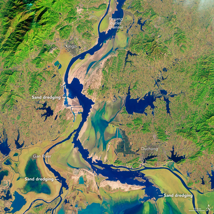
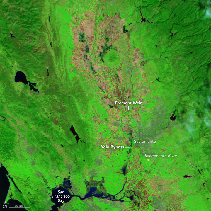
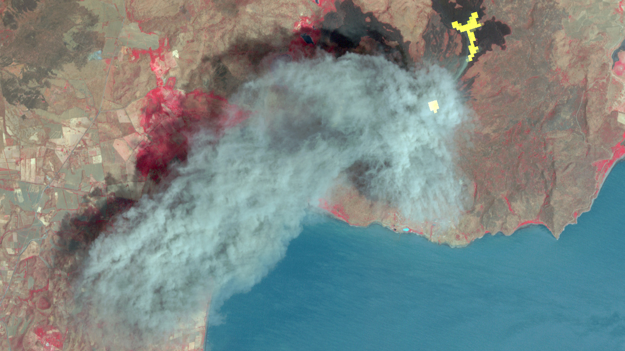
The public will have unlimited access to the complete 16-plus-year database for Japan’s Ministry of Economy, Trade and Industry (METI) Advanced Spaceborne Thermal Emission and Reflection Radiometer (ASTER) instrument, which images Earth to map and monitor the changing surface of our planet. ASTER’s database currently consists of more than 2.95 million individual scenes. The content ranges from massive scars across the Oklahoma landscape from an EF-5 tornado and the devastating aftermath of flooding in Pakistan, to volcanic eruptions in Iceland and wildfires in California.

Previously, users could access ASTER’s global digital topographic maps of Earth online at no cost, but paid METI a nominal fee to order other ASTER data products.

In announcing the change in policy, METI and NASA cited ASTER’s longevity and continued strong environmental monitoring capabilities. Launched in 1999, ASTER has far exceeded its five-year design life and will continue to operate for the foreseeable future as part of the suite of five Earth-observing instruments on Terra.

“We anticipate a dramatic increase in the number of users of our data, with new and exciting results to come,” said Michael Abrams, ASTER science team leader at NASA’s Jet Propulsion Laboratory in Pasadena, California, home to ASTER’s U.S. science team. ASTER data are processed into products using algorithms developed at JPL and the National Institute of Advanced Industrial Science and Technology (AIST) in Japan. A joint U.S./Japan science team validates and calibrates the instrument and data products.

ASTER is used to create detailed maps of land surface temperature, reflectance and elevation. The instrument acquires images in visible and thermal infrared wavelengths, with spatial resolutions ranging from about 50 to 300 feet (15 to 90 meters). ASTER data cover 99 percent of Earth’s landmass and span from 83 degrees north latitude to 83 degrees south. A single downward-looking ASTER scene covers an area on the ground measuring about 37-by-37 miles (60-by-60-kilometers).

ASTER uses its near-infrared spectral band and downward- and backward-viewing telescopes to create stereo-pair images, merging two slightly offset two-dimensional images to create the three-dimensional effect of depth. Each elevation measurement point in the data is 98 feet (30 meters) apart.

The broad spectral coverage and high spectral resolution of ASTER provide scientists in numerous disciplines with critical information for surface mapping and monitoring of dynamic conditions and changes over time. Example applications include monitoring glacial advances and retreats, monitoring potentially active volcanoes, identifying crop stress, determining cloud morphology and physical properties, evaluating wetlands, monitoring thermal pollution, monitoring coral reef degradation, mapping surface temperatures of soils and geology, and measuring surface heat balance.

ASTER data are now available via electronic download from NASA’s Land Processes Distributed Active Archive Center (LP DAAC) at the U.S. Geological Survey’s (USGS) Earth Resources Observation and Science Center in Sioux Falls, South Dakota, and from AIST. To access the data, visit:

https://lpdaac.usgs.gov/dataset_discovery/aster

or

https://gbank.gsj.jp/madas/

NASA uses the vantage point of space to increase our understanding of our home planet, improve lives and safeguard our future. NASA develops new ways to observe and study Earth’s interconnected natural systems with long-term data records. The agency freely shares this unique knowledge and works with institutions around the world to gain new insights into how our planet is changing.

For more information about ASTER, visit:

http://asterweb.jpl.nasa.gov/

For more information on NASA’s Terra mission, visit:

https://terra.nasa.gov

For more information about NASA’s Earth science activities, visit:

http://www.nasa.gov/earth


News Media Contact

Alan Buis
Jet Propulsion Laboratory, Pasadena, Calif.
818-354-0474
Alan.buis@jpl.nasa.gov

Images of Wolf volcano on June 11, 2016. Image on left is from ASTER, showing Wolf Volcano in great detail. The image on the right is from MODIS. The red mark indicates a temperature anomaly or hot spot. Image Credit: Aster image from NASA Earth Observatory by Jesse Allen, using data from NASA/GSFC/METI/ERSDAC/JAROS, and U.S./Japan ASTER Science Team. MODIS image from NASA Worldview.

Images of Wolf volcano on June 11, 2015. ASTER image (left) shows Wolf Volcano in great detail. MODIS image (right) red marks indicate temperature anomalies or hot spots. Image Credit: Aster image from NASA Earth Observatory by Jesse Allen, using data from NASA/GSFC/METI/ERSDAC/JAROS, and U.S./Japan ASTER Science Team. MODIS image from NASA Worldview.

Not every volcano is as closely observed as Mount Saint Helens in Washington state or Mount Kilauea of Volcanoes National Park in Hawaii. These active volcanoes are closely monitored with specialized instruments dedicated to monitoring signs of volcanic activity. They are the exception, not the norm. Many volcanoes are remotely located and poorly monitored. However, NASA’s Terra satellite is helping identify potentially active volcanoes, better equipping surrounding communities to evacuate or take precautions before their local volcano erupts.

Two instruments on NASA’s Terra satellite, the Moderate Imaging Spectroradiometer (MODIS) and the Advanced Spaceborne Thermal Emissions and Reflection Radiometer (ASTER), along with instruments on other NASA and NOAA satellites are being used to identify and monitor potential areas of volcanic activity as part of the Urgent Request Protocol.

Not one satellite can do it all. “Monitoring of active volcanic processes using spaceborne data commonly requires different temporal, spatial and spectral scales depending on the science goal and process being observed,” according to Michael Ramsey from the University of Pittsburgh in his recent article, published on December 17, 2015.

Hotspots on Earth are identified by satellite images that have a thermal sensor, which measures the temperature, or infrared radiation, of Earth’s surface.MODIS, the Advanced Very High Resolution Radiometer (AVHRR) and ASTER all collect data on Earth’s temperature, but each of these sensors have different spatial resolutions. MODIS and AVHRR image large areas frequently, but lack detail. ASTER, on the other hand, has high spatial and spectral resolution, but lacks frequency.

AVHRR, MODIS and ASTER teamed up as part of the Urgent Request Protocol. AVHRR data was initially used exclusively until 2011, when MODIS data was integrated into the system. AVHRR and MODIS identify temperature changes on Earth’s surface that could indicate volcanic activity. These areas are flagged as being potentially active. When they are flagged, these locations are sent automatically to the Urgent Request Protocol database, where a request is submitted that ASTER look at these locations more closely on its next opportunity.

This allows stakeholders to potentially track detailed changes on that site every time ASTER passes. Prior to 2011, scientists manually reviewed flagged hotspots before being submitted to the Urgent Request Protocol for imaging by ASTER.

One benefit of using MODIS data over AVHRR is that it allows the system to be automated because MODIS data has less noise than AVHRR and has a higher detection threshold, reducing the number of false positives detected. Additionally, MODIS data is part of a global system where as the volcanic monitoring from AVHRR is isolated to the north Pacific region.

Beyond its global reach, the Urgent Request Protocol is one of the longest running programs focused on mission operations and volcanic science. Stakeholders and scientists anticipate the launch of the Hyperspectral Infrared Imager (HyspIRI), which will have a thermal infrared imager similar to ASTER on board. Information acquired by ASTER is used in the development of HyspIRI and future thermal infrared sensors, contributing to the extended satellite record and the next generation of Earth observing satellites tracking volcanic threats from space.

Watching from their vantage point outside of Earth, satellites will continue to witness volcanic eruptions and volcanic activity. While no one satellite can see the whole picture, when multiple satellites with the ability to measure Earth’s temperature frequently or in great detail are used together like in the Urgent Request Protocol, people benefit. The strong foundation laid by the Urgent Request Protocol will allow new data from the next fleet of satellites to continue to help people prepare for volcanic incidents.

momotombo_ast_2016062

Image Credit: NASA Earth Observatory image by Jesse Allen, using data from NASA/GSFC/METI/ERSDAC/JAROS, and U.S./Japan ASTER Science Team.

March 5, 2016
Eruption at Momotombo– The Advanced Spaceborne Thermal Emission and Reflection Radiometer on NASA’s Terra Satellite aquired this false color image of Momotombo volcano in Nicaragua erupting on March 2, 2016.


March 16, 2016
Flooding in the U.S. South– The Moderate Imaging Spectroradiometer on NASA’s Terra Satellite captured images of the flooding waters on the Mississippi River and White River in the southern United States.


March 18, 2016
Sand Mining at Poyang Lake– As part of an effort to assess the scale of the sand mining and its environmental impacts, a group of researchers analyzed data collected by the Advanced Spaceborne Thermal Emission and Reflection Radiometer (ASTER) sensor on NASA’s Terra satellite. Using infrared data collected by ASTER in 2005, the researchers found that the lake was producing up to 236 million cubic meters of sand per year—about 9 percent of the total produced by China. The researchers estimated that the volume of sand removed was probably enough to make Poyang Lake the largest sand mining operation in the world.


March 19, 2016
Northern California Floodway Fills– The Moderate Resolution Imaging Spectroradiometer (MODIS) on NASA’s Terra satellite captured  images of the river and floodway in northern California.  Storms in March 2016 brought water levels in this drought stricken region back to it’s historic average.