Month: October 2015

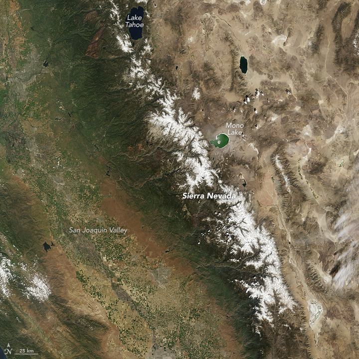
sierranevada_tmo_2015090Snowpack in the Sierra Nevada range in Central California is at a record low. The Moderate Imaging Spectroradiometer on NASA’s Terra satellite captured this image, published on NASA’s Earth Observatory, of the Sierra Nevada, showing just how brown these typically very white, snow covered mountains have become since 2011, a wet and snowy year with extensive snow pack. To compare images from 2011 with 2015, used the image comparison tool on the NASA Earth Observatory site.

Since 2011, winter snow pack decreased, reducing amounts of melt water in the spring and summer. In March of 2015, ground-based monitoring sites in the Sierras reported that there was no snow cover for the first time ever, while about one-third of the sites were measuring at the lowest snow pack ever recorded.

In a recent article in Nature Climate Change, scientists from the University of Arizona used tree-ring records of precipitation anomalies to construct a 500-year history of snow water equivalent on the Sierra Nevada, showing just how unprecedented this lack of snow pack is in the past 500 years.

Read more on NASA’s Earth Observatory

Read the article on Nature Climate Change

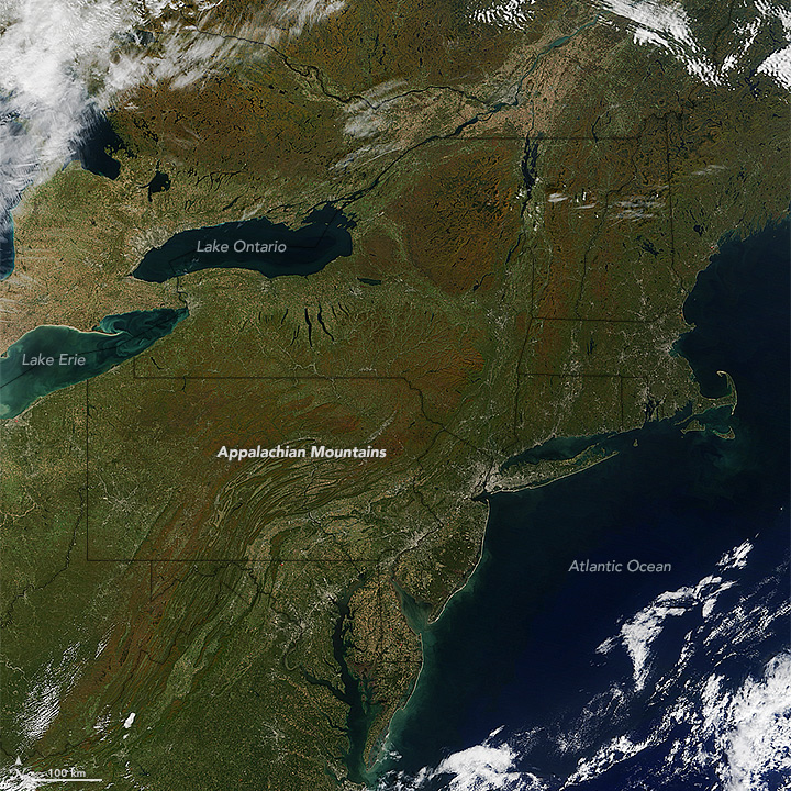
Fall colors on eastern seaboard as seen by Terra MODIS

NASA images by Jeff Schmaltz, LANCE/EOSDIS Rapid Response.

It’s time for the annual Fall color display across part of the Northern Hemisphere.  The Moderate Resolution Imaging Spectroradiometer (MODIS) on NASA’s Terra satellite captured the colorful changing foliage on October 11, 2015. As temperatures drop and sunlight fades, the leaves begin to change colors. This image was recently featured on NASA’s Earth Observatory.

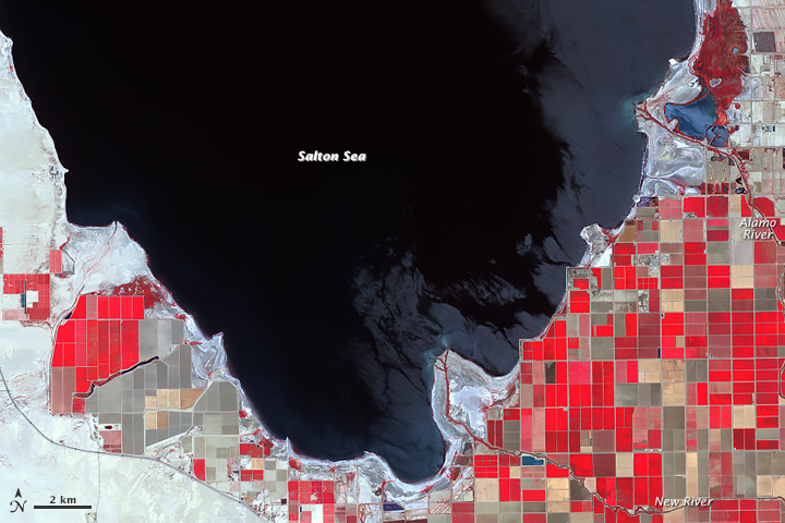
Salton Sea as seen by ASTER

NASA Earth Observatory images by Jesse Allen, using ASTER data from NASA/GSFC/METI/ERSDAC/JAROS, and U.S./Japan ASTER Science Team, and Landsat data from the U.S. Geological Survey.

Fed primarily from agricultural irrigation runoff, the Salton Sea in southern California’s Sonoran Desert has dropped by 8 feet since 1984. While drought in California has contributed to the receding shoreline, water conservation efforts also play a role. The sea may be reduced to two small pools by the 2030s. The Advanced Spaceborne Thermal Emission and Reflection Radiometer (ASTER) on NASA’s Terra satellite captured this image showing the exposed Deltas along its southern shore.

Read the whole article on NASA’s Earth Observatory

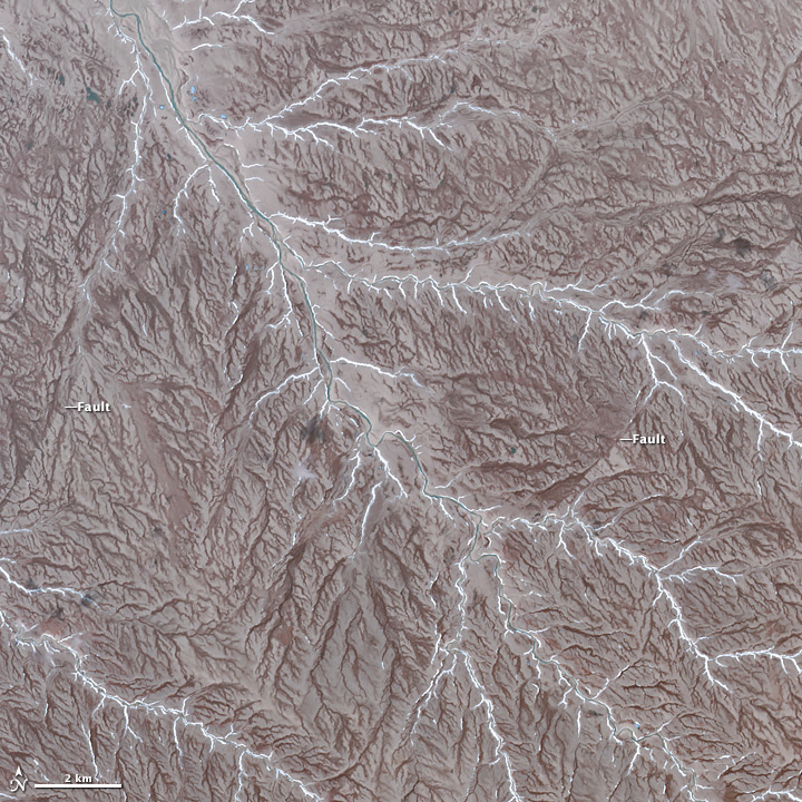
Aster Image of Patrick Island

NASA Earth Observatory image by Jesse Allen, using data from NASA/GSFC/METI/ERSDAC/JAROS, and U.S./Japan ASTER Science Team.

The Advanced Spaceborne Thermal Emission and Reflection Radiometer (ASTER) on NASA’s Terra satellite, captured the image of Prince Patrick Island in Northern Canada. The image was featured on NASA’s Earth Observatory, showing the dendritic drainage pattern of interlocking steam and river channels, as well as, strike-slip faults, evidence of Prince Patrick’s seismic history. Prince Patrick Island is usually surrounded in sea ice, while temperatures average -33 degrees Celcius in January. This cold, inhospitable terrain is not a frequent travel destination, but through satellite imagery, much can be learned about this mostly uninhabited part of our planet.

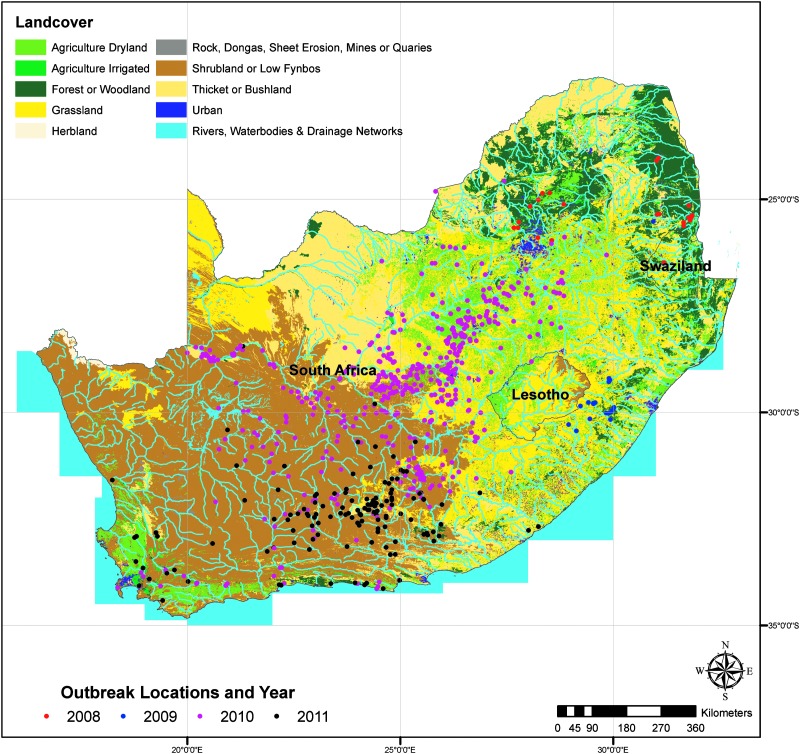
Reported Rift Valley fever (RVF) case locations in relation to Land Use/Land Cover. Image courtesy of: Margaret M. Glancey, et al., 2015; Published by Mary Ann Liebert, Inc.

Reported Rift Valley fever (RVF) case locations in relation to Land Use/Land Cover. Image courtesy of: Margaret M. Glancey, et al., 2015; Published by Mary Ann Liebert, Inc.

Moderate Imaging Spectroradiometer (MODIS) data in the Normalized Difference Vegetation Index (NDVI), an index that shows plants “greenness” or photosynthetic activity, is helping better understand risk factors associated with Rift Valley Fever outbreaks in Southern Africa.

A recent study published in the National Center for Biotechnology Information’s Pub Med looked at epidemiological and environmental risk factors from 2008 – 2011, the worst outbreak of Rift Valley fever in almost 40 years.

Periods of widespread and above-normal rainfall are associated with Rift Valley Fever outbreaks. Researchers combined data from the World Animal Health Information Database (WAHID) on what types of species were affected, where and when with environmental factors including rainfall and NDVI.

The results of the study show that these environmental factors along with geographic factors (topography, drainage, and land use) do play a role in the emergence of Rift Valley Fever.

This study will help the accuracy of future models of areas at risk, allowing more time to adequately prepare and prevent future outbreaks.

Read the full article at http://www.ncbi.nlm.nih.gov/pubmed/26273812