This article from IEEE talks about how satellite data can predict agricultural output and famine. Terra plays a large role in measuring the National Data Vegetation Index (NDVI), which is measured using spectral bands 1 and 2 (infrared to visible light) of the Moderate-resolution Imaging Spectroradiometer. NDVI compares the amount of light reflected in near-infrared with that reflected in visible light; if there is more infrared, the vegetation in that spot is likely to be dense and thus yield more of the crop.” Armed with this information and data from other satellites researchers are able to get a better picture of how the worlds crops are faring. Read more
Past News
- December 2025
- October 2025
- July 2025
- May 2025
- February 2025
- November 2024
- April 2024
- February 2024
- December 2023
- October 2023
- April 2023
- February 2023
- December 2022
- October 2022
- August 2022
- July 2022
- June 2022
- April 2022
- March 2022
- October 2021
- September 2021
- August 2021
- June 2021
- May 2021
- April 2021
- March 2021
- February 2021
- January 2021
- September 2020
- August 2020
- July 2020
- April 2020
- February 2020
- January 2020
- December 2019
- November 2019
- October 2019
- September 2019
- August 2019
- April 2019
- March 2019
- November 2018
- October 2018
- August 2018
- July 2018
- June 2018
- May 2018
- November 2017
- June 2017
- August 2016
- July 2016
- June 2016
- May 2016
- April 2016
- March 2016
- February 2016
- January 2016
- December 2015
- November 2015
- October 2015
- September 2015
- August 2015
- April 2015
- February 2015
- December 2014
- November 2014
- October 2014
- September 2014
- August 2014
- May 2014
- April 2014
- March 2014
- February 2014
- January 2014
- December 2013
- November 2013
- October 2013
- September 2013
- August 2013
- July 2013
- June 2013
- May 2013
- April 2013
- March 2013
- February 2013
- January 2013
- September 2012
- June 2012
- May 2012
- April 2012
- March 2012
- February 2012
- January 2012
News By Instrument
News By Science
- Air quality
- Applications
- Atmosphere
- Carbon Cycle and Ecosystems
- Climate Variability and Change
- Data
- Earth Observatory
- Earth's Surface and Interior
- Education
- Energy Cycle
- Events
- Human Dimensions
- LAADS DAAC
- Landsat
- Orbital Changes
- Platform
- Resources
- Terra Talent Series
- Terra Visits Camp Landsat
- VIIRS
- Water Cycle
- Weather
- Wildfire
Month: May 2013
Pavlof Volcano Erupts
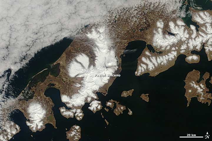
For the third time this century, Alaska’s Pavlof Volcano is erupting. The Alaska Volcano Observatory first detected earthquakes associated with the movement of magma and heat at Pavlof’s summit on May 13, 2013. The Moderate Resolution Imaging Spectroradiometer (MODIS) on the Terra satellite captured this image of a small ash plume and lava flow on the morning of May 14. Read more
Lingering Ice on Minnesota Lakes
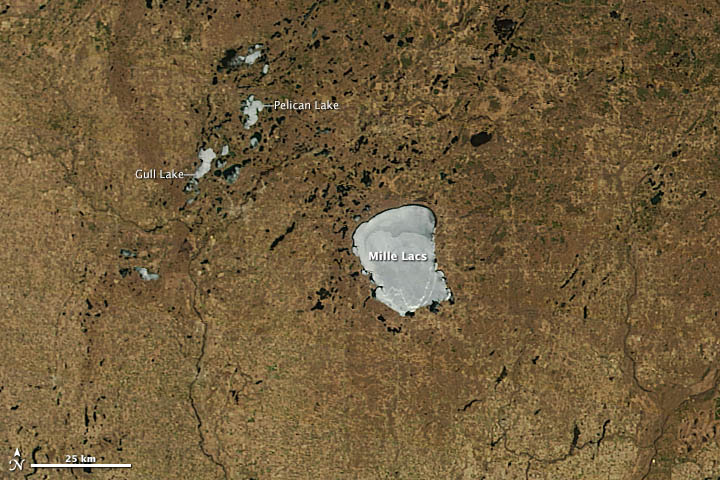
When the Moderate Resolution Imaging Spectroradiometer (MODIS) instrument on NASA’s Terra satellite passed over northern Minnesota on May 12, 2013, spring had transformed winter’s snowy white landscape into shades of green and brown. But several lakes remained stubbornly white. In 2013, unseasonably cool spring weather has left ice choking many of Minnesota’s lakes weeks longer than usual. Read more
NASA’s Reel Science Communications Challenge Winners Announced
NASA has selected the winners of NASA’s educational “REEL Science Communications” video contest. The three winning videos were created by students in New Jersey, North Carolina and California. There were also six videos chosen as runners-up.
The three winning videos were “All About Ozone,” produced by Michelle Goffreda and Ananya Joshi of Lincroft, N.J.; “Hurricanes,” by Erik Borchers and Will Reiss of Raleigh, N.C.; and “Ship Tracks,” by Michelle Ko of Pasadena, Calif. Read more


