Tag: air quality

NO2 and CO mean differences  maps

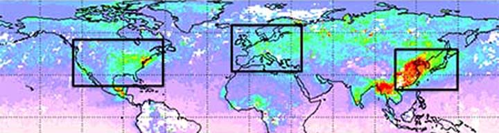
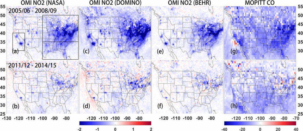
Difference of mean tropospheric OMI NO2 columns from 2005–2006 to 2008–2009, and from 2011–2012 to 2014–2015. The unit is 1015 mole/cm2. (G and H) same as A–F, but for MOPITT surface layer CO measurements with unit ppb (parts per billion).

A recent article published in PNAS points out that efforts to reduce nitrogen dioxide and carbon monoxide emissions between 2011 – 2015 have slowed in the United States, despite previous estimates that emissions were decreasing. These “bottom-up” estimates used ground-based measurements, inventories and models to predict these smog-producing emissions. However, when viewed from above, through satellite data from MOPITT and OMI, both nitrogen dioxide and carbon monoxide levels have not decreased.

Researchers concluded that emissions, especially for nitrogen dioxide, have not decreased as thought because of vehicle and industrial emissions. Industrial and construction equipment emissions are growing, while heavy duty truck diesel emissions may have been overlooked in ground-based measurements.  Car emissions also continue to be a pollution source, but are now contributing a smaller proportion of total emissions.

One thing is certain, that viewing from above gives scientists the opportunity to see the whole United States, instead of relying on site specific ground based measurements.

Read more about it in the news:

Los Angeles Times: Slowdown in emissions reductions could explain stalled progress on smog, study finds

Bloomberg: Your air isn’t getting as clean as the EPA said it is

USA Today: The USA’s long battle against air pollution isn’t over yet, as air quality improvements are slowing down

Associated Press (on Tampa Bay Times website): America’s air isn’t getting cleaner as fast as it used to

MISR with it’s multiple angled views of the Tinder fire, makes it uniquely capable of tracking the plume height and direction of one of the first fires of the 2018 season in the United States. The fire started on April 27th, 2018 from an abandoned campsite and quickly spread through, Cococino National Forest in, eastern Arizona. This MISR data is from April 30th, 2018, showing the plume height and direction. The plume reached nearly 4 kilometers high near the source of the fire. Typically the higher a plume reaches, the further the impact extends. Scientists are using data like this to better understand how fires impact air quality beyond the source area.

Read more:

Using Satellites to Track the Tinder Fire  on NASA Earth Observatory

Tinder Fire in Arizona Viewed by NASA’s MISR from JPL’s Photojournal


caspiansea_amo_2016158

Does Dust Affect Water Levels of the Caspian Sea

June 10, 2016

Dust storms over the Caspian Sea lead to increased evaporation and a drop in lake level according to new research using observations of dust collected by instruments on several satellites including the Moderate Imaging Spectroradiometer (MODIS ) and the Multi-angle Imaging Spectroradiometer (MISR) on Terra.


ruapehu_ast_2016111

A Satellite Eye on Mount Ruapehu

June 5, 2010

Mount Ruapehu is one of New Zealand’s most active volcanoes and most visited, dotted with skiers and snowboarders along its slopes.  When it erupts lahars, flows of volcanic debris and sediment, can have devastating impacts, prompting geologists to regularly monitor the volcano, using the Advanced Spaceborne Thermal Emission and Reflection Radiometer on NASA’s Terra satellite.


Measurements of carbon monoxide in April 2014 from the MOPITT instrument (Measurement of Pollution in the Troposphere) aboard NASA’s globally orbiting Terra spacecraft. The boxes show the observing domains for geostationary satellites and red colors indicate high levels of carbon monoxide. (©UCAR. Image courtesy Helen Worden, NCAR

Measurements of Pollution in the Troposphere (MOPITT) on NASA’s Terra satellite is being used to prove a concept in which new geostationary satellites could improve how agencies monitor and forecast air quality. Chemistry-climate model output would be combined from satellite data from a fleet of geostationary satellites.

“We think the new perspective made possible by geostationary sensors would provide data that is useful for everyday air quality forecasting, as well as for early warnings about extreme events, like the effects of wildfires,” said Helen Worden, NCAR scientist and member of the research team, according to the UCAR website.

MOPITT provides one to two measurements over a given location per day. The geostationary fleet would allow multiple measurements of certain locations per day, making it possible to track emissions over rush hour versus lower traffic times in some urban areas.

The statistical technique used to test the geostationary fleet as a proof of concept was first developed to analyze data from MOPITT, which pioneered the measurement of carbon monoxide from space.

To find out more read the full article from UCAR https://www2.ucar.edu/atmosnews/just-published/17531/tracking-air-quality-high-sky