Terra, among a satellites from many nations, joined the effort in the search for Malaysian Airlines Flight MH-370. Read more


The EOS Flagship
Past News
- December 2025
- October 2025
- July 2025
- May 2025
- February 2025
- November 2024
- April 2024
- February 2024
- December 2023
- October 2023
- April 2023
- February 2023
- December 2022
- October 2022
- August 2022
- July 2022
- June 2022
- April 2022
- March 2022
- October 2021
- September 2021
- August 2021
- June 2021
- May 2021
- April 2021
- March 2021
- February 2021
- January 2021
- September 2020
- August 2020
- July 2020
- April 2020
- February 2020
- January 2020
- December 2019
- November 2019
- October 2019
- September 2019
- August 2019
- April 2019
- March 2019
- November 2018
- October 2018
- August 2018
- July 2018
- June 2018
- May 2018
- November 2017
- June 2017
- August 2016
- July 2016
- June 2016
- May 2016
- April 2016
- March 2016
- February 2016
- January 2016
- December 2015
- November 2015
- October 2015
- September 2015
- August 2015
- April 2015
- February 2015
- December 2014
- November 2014
- October 2014
- September 2014
- August 2014
- May 2014
- April 2014
- March 2014
- February 2014
- January 2014
- December 2013
- November 2013
- October 2013
- September 2013
- August 2013
- July 2013
- June 2013
- May 2013
- April 2013
- March 2013
- February 2013
- January 2013
- September 2012
- June 2012
- May 2012
- April 2012
- March 2012
- February 2012
- January 2012
News By Instrument
News By Science
- Air quality
- Applications
- Atmosphere
- Carbon Cycle and Ecosystems
- Climate Variability and Change
- Data
- Earth Observatory
- Earth's Surface and Interior
- Education
- Energy Cycle
- Events
- Human Dimensions
- LAADS DAAC
- Landsat
- Orbital Changes
- Platform
- Resources
- Terra Talent Series
- Terra Visits Camp Landsat
- VIIRS
- Water Cycle
- Weather
- Wildfire
Month: March 2014
Clear Skies Over the Iberian Peninsula
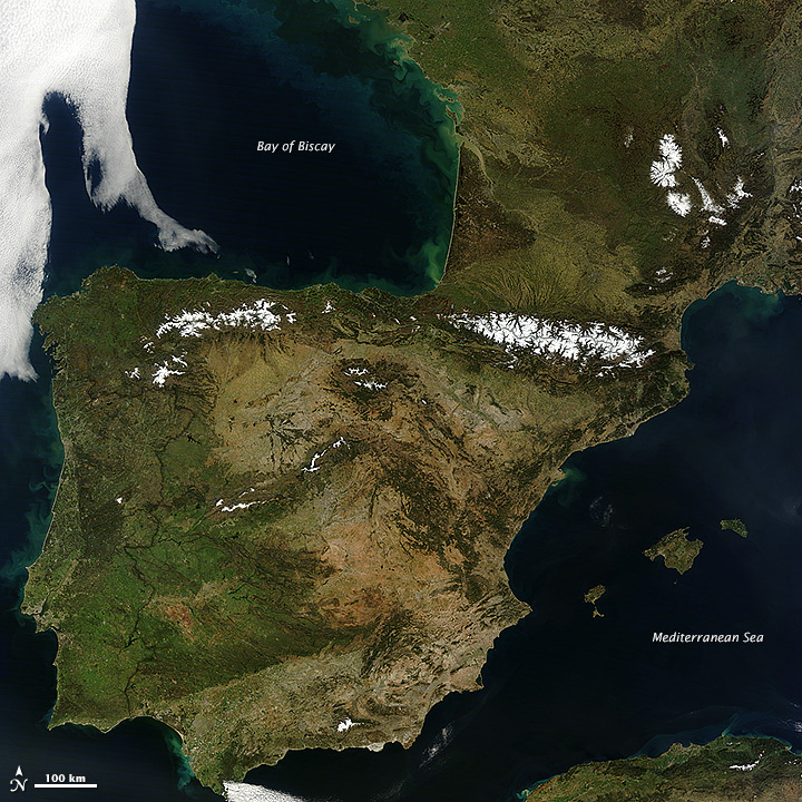
Rarely do weather patterns and satellite overpass schedules align to provide cloud-free views of Western Europe in the spring. However, a high-pressure pattern kept skies spectacularly clear over the Iberian Peninsula and east into France and Germany as the Moderate Resolution Imaging Spectroradiometer (MODIS) on NASA’s Terra satellite passed over on March 8, 2014. The cloud-free area began to emerge on March 5 and persisted through March 11. Explore Worldview—a near-real time browser from the MODIS Rapid Response Team—to see a wider view and how the cloud-free area changed over time. Read more
- NASA image courtesy Jeff Schmaltz, LANCE/EOSDIS MODIS Rapid Response Team at NASA GSFC. Caption by Adam Voiland.
Some Perspective on Winter 2014
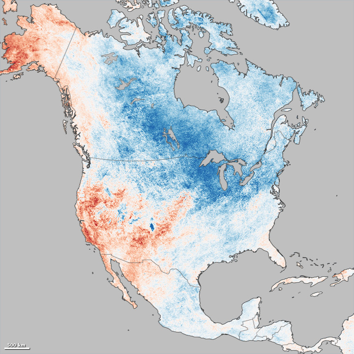
For many residents of North America, the winter of 2013-14 has felt like one of the coldest in many years. Waves of Arctic air brought extended periods of cold weather and above-average snowfall to the middle and eastern portions of the United States and Canada. Seven Midwestern states had one of their top-ten coldest winters, and the Great Lakes were chilled until they reached nearly 91 percent ice cover. Even portions of Mexico and Central America were cooler than normal. Read More
- NASA Earth Observatory images by Jesse Allen, using MODIS data from the Land Processes Distributed Active Archive Center (LPDAAC). Caption by Michael Carlowicz.
Dust Storm Blows Across Texas
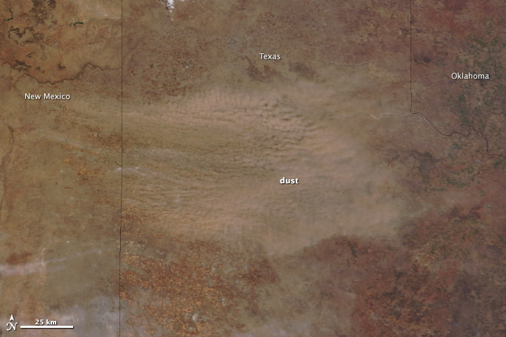
A low-pressure system brought strong winds—gusting to 55 miles (85 kilometers) per hour—to the Southern Plains on March 18, 2014. The winds picked up exposed soil from the parched landscape, resulting in a large dust storm that covered parts of Colorado, Kansas, Oklahoma, New Mexico, and Texas. The storm was the second in the past week to sweep across the region with similar wind patterns.
The Moderate Resolution Imaging Spectroradiometer (MODIS) acquired this image of the storm on March 18. The top image shows the dust over the Texas Panhandle at 1:15 p.m. Central Daylight Time from the MODIS instrument on NASA’s Terra satellite. Read more
- NASA images courtesy Jeff Schmaltz, LANCE/EOSDIS MODIS Rapid Response Team at NASA GSFC. Caption by Holli Riebeek.
Cape Verde Under Dust
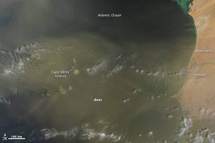
When the winds of winter sweep across West Africa, temperatures drop and skies turn yellow. Prevalent from November to March, the harmattan is a desert wind that blows across the Sahara Desert from the northeast or the east, usually as a result of a high pressure system over the northwestern Sahara. Harmattan winds pick up dust and darken skies.
A harmattan dust storm was blowing on February 28, 2014, when the Moderate Resolution Imaging Spectroradiometer (MODIS) on NASA’s Terra satellite acquired this image. The yellow dust was concentrated largely over the Cape Verde Islands, where the mountain topography created swirling eddies and triangular wakes in the dust cloud. West Africa frames the right edge of the image, and distinct plumes of dust moved west from Senegal and Mauritania. Read more
- NASA image courtesy Jeff Schmaltz, LANCE/EOSDIS MODIS Rapid Response Team at NASA GSFC. Caption by Holli Riebeek.