Month: April 2014

NASA images courtesy Jeff Schmaltz, LANCE/EOSDIS MODIS Rapid Response Team at NASA GSFC. Caption by Holli Riebeek.

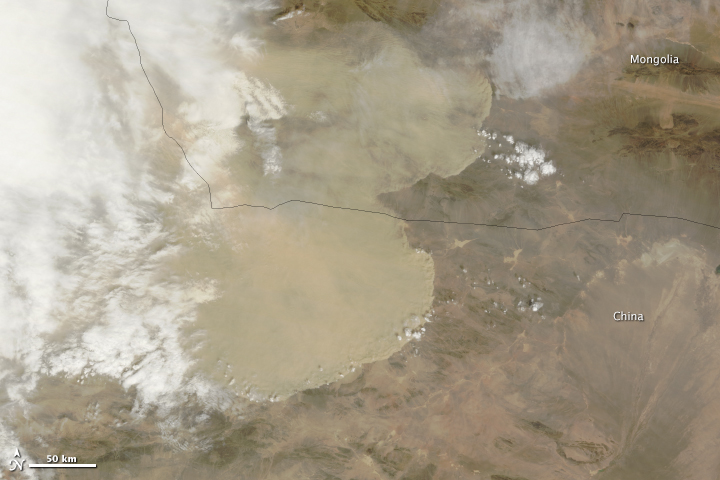
A wall of dust was barreling across northern China on April 23, 2014, when the Moderate Resolution Imaging Spectroradiometer (MODIS) acquired these images from NASA’s Aqua and Terra satellites. The top image was taken at 12:35 p.m. local time, and the lower image is from 2:20 p.m. Turn on the image comparison tool to see how far the dust advanced in the two hours between images. Read more

NASA images courtesy Jeff Schmaltz, LANCE/EOSDIS MODIS Rapid Response Team at NASA GSFC. Caption by Holli Riebeek.

The 2014 MODIS Science Team Meeting will take place at the Sheraton Columbia Town Center Hotel in Columbia, MD from April 29th through May 1. Please see the agenda for times of sessions and a list of speakers.

NASA image courtesy Jeff Schmaltz, LANCE/EOSDIS MODIS Rapid Response Team at NASA GSFC. Caption by Holli Riebeek.

Air flows like water in the atmosphere with invisible currents and waves. On April 9, 2014, the Moderate Resolution Imaging Spectroradiometer (MODIS) on NASA’s Terra satellite captured this view that evokes fluid-like movement in the atmosphere. Ship wave clouds fan out behind the Crozet Islands over the southern Indian Ocean looking exactly like the ripples behind a rock in a stream or the waves behind a boat moving through calm water. Read more

NASA image courtesy Jeff Schmaltz, LANCE/EOSDIS MODIS Rapid Response Team at NASA GSFC. Caption by Holli Riebeek.

NASA image courtesy LANCE/EOSDIS MODIS Rapid Response Team, GSFC. Caption by Adam Voiland and Michael Carlowicz.

The satellites in NASA’s Earth Observing System collect data and imagery for scientific research. The data goes to one of twelve Distributed Active Archive Centers (DAACs) across the United States, where it is processed and distributed to scientists who mine it for clues about our environment.

But sometimes the imagery is remarkable simply for its beauty. When the Moderate Resolution Imaging Spectroradiometer (MODIS) on NASA’s Terra satellite looked down on the Lesser Antilles on August 1, 2013, the combination of sunlight, islands, and wind painted this scene on the surface of the Caribbean Sea. The right side of the image has a milky hue because of sunglint, an optical effect caused by the mirror-like reflection of sunlight off the water surface directly back at the satellite sensor. Read more

NASA image courtesy LANCE/EOSDIS MODIS Rapid Response Team, GSFC. Caption by Adam Voiland and Michael Carlowicz.

NASA images by Jeff Schmaltz, LANCE/EOSDIS Rapid Response. Caption by Michael Carlowicz.

In early November 2013, a large iceberg separated from the front of Antarctica’s Pine Island Glacier. It thus began a journey across Pine Island Bay, a basin of the Amundsen Sea. The ice island, named B31, will likely be swept up soon in the swift currents of the Southern Ocean, though it will be hard to track visually for the next six months as Antarctica heads into winter darkness.

Over the course of five months in Antarctic spring and summer, the Moderate Resolution Imaging Spectroradiometer (MODIS)—an instrument on NASA’s Terra and Aqua satellites—captured a series of images of ice island B31. Read more

NASA images by Jeff Schmaltz, LANCE/EOSDIS Rapid Response. Caption by Michael Carlowicz.