Month: April 2014

NASA image by Robert Simmon with ASTER data. Caption by Holli Riebeek with information and review provided by David Mayer, Robert Simmon, and Michael Abrams.

A satellite image is more than a photo. It is a picture of the amount and type of energy reflected or emitted by the Earth and recorded by a satellite instrument. There are many ways to combine those measurements to create an image, and each combination provides different insights.

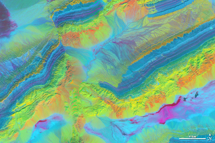
The spectacular exposed geology of northwestern China offers an ideal landscape for illustrating how satellite measurements can identify minerals from afar. In satellite imagery, this area has three different sedimentary rock layers that are visible as rainbow stripes on a series of ridges. The Piqiang Fault has split the ridgeline, so the colored layers are offset by about three kilometers (two miles). All of the images on this page were made from data acquired on February 24, 2005, by the Advanced Spaceborne Thermal Emission and Reflection Radiometer (ASTER) on NASA’s Terra satellite. Read more

NASA image by Robert Simmon with ASTER data. Caption by Holli Riebeek with information and review provided by David Mayer, Robert Simmon, and Michael Abrams.

NASA image courtesy LANCE/EOSDIS MODIS Rapid Response Team at NASA GSFC. Caption by Holli Riebeek.

High winds propelled a wildfire through parts of Valparaiso, Chile, on April 13, 2014. It quickly became the largest fire in the history of this port city. The fire started in a forested area on April 12 and eventually reached wooden homes built on steep hills around the city. According to news reports, at least 12 people died, 2,000 homes were destroyed, and about 10,000 people evacuated as the fire moved through a section of the historic city.

The Moderate Resolution Imaging Spectroradiometer (MODIS) on NASA’s Terra satellite acquired this image of the fire at 11:10 am local time (14:10 UTC) on April 13. Fire detections are outlined in red in the forest south of the city, which is pale gray. A long plume of smoke stretches northwest over the Pacific Ocean, a clear indication that winds were strong and blowing the flames toward the city. Read more

NASA image courtesy LANCE/EOSDIS MODIS Rapid Response Team at NASA GSFC. Caption by Holli Riebeek.

NASA image courtesy Jeff Schmaltz LANCE/EOSDIS MODIS Rapid Response Team, GSFC. Caption by Mike Carlowicz, with assistance from Jeff Schmaltz and Will Stefanov.

The second annual Tournament: Earth has come to an end, and the winner is a familiar face. In 2013, a submarine volcano off of the Canary Islands took the first championship. This year, the entire island chain got in on the action. ”Trailing the Canaries,” the #2 seed in the art bracket, romped through the tournament in 2014. The image showed interesting wind and wave patterns in sunglint on the lee side of the islands. The Canary Islands have a lot of fans! Read more

NASA image courtesy Jeff Schmaltz LANCE/EOSDIS MODIS Rapid Response Team, GSFC. Caption by Mike Carlowicz, with assistance from Jeff Schmaltz and Will Stefanov.

NASA image courtesy Jeff Schmaltz, LANCE/EOSDIS MODIS Rapid Response Team at NASA GSFC. Caption by Holli Riebeek.

On Sunday, March 30, 2014, the outlook appeared grim for cities in northwestern Madagascar. Tropical cyclone Hellen spun offshore, gaining strength with surprising rapidity and with a track destined to bring it ashore. The day started with the storm being the equivalent of a Category 2 storm with winds of 170 kilometers per hour (100 miles per hour or 90 knots). Twelve hours later, winds reached 240 kilometers per hour (150 miles per hour or 130 knots), making it a strong Category 4 storm.

The Moderate Resolution Imaging Spectroradiometer (MODIS) on NASA’s Terra satellite acquired this image of Cyclone Hellen at 7:20 UTC on March 30 in the middle of the storm’s rapid intensification. The storm had a distinct open eye and a classic tight circular shape. Its outer bands were already over northwestern Madagascar. Read more

NASA image courtesy Jeff Schmaltz, LANCE/EOSDIS MODIS Rapid Response Team at NASA GSFC. Caption by Holli Riebeek.

NASA Earth Observatory image by Robert Simmon, using data from Patrick Jantz and Alessandro Baccini at Woods Hole Research Center. Caption by Mike Carlowicz.

“To create the corridors, Jantz started with a tropical carbon map that Goetz, Laporte, Alessandro Baccini, and other WHRC scientists developed a few years ago. That map included data from NASA’s ICESat, Terra, and Aqua satellites, Japan’s ALOS satellite, the Shuttle Radar Topography Mission, and from thousands of ground-based observations. The tropical carbon map became the base layer on the map above.” Read more

NASA Earth Observatory image by Robert Simmon, using data from Patrick Jantz and Alessandro Baccini at Woods Hole Research Center. Caption by Mike Carlowicz.