Image from TERRA
Tue, 20 Sep 2022 10:30 EDT

Water departments in the West are using maps and models originally created by a NASA team to help track water.

Image from TERRA
Thu, 15 Sep 2022 10:00 EDT

NASA and Google broadened an existing partnership to help local governments improve their monitoring and prediction of air quality for better decision making.

Image from TERRA
Mon, 11 Jul 2022 09:30 EDT

Ozone pollution assessments made for the Great Lakes region now include NASA satellite and other near-real time Earth observations.

Corridors for Carbon and Critters

NASA Earth Observatory image by Robert Simmon, using data from Patrick Jantz and Alessandro Baccini at Woods Hole Research Center. Caption by Mike Carlowicz.

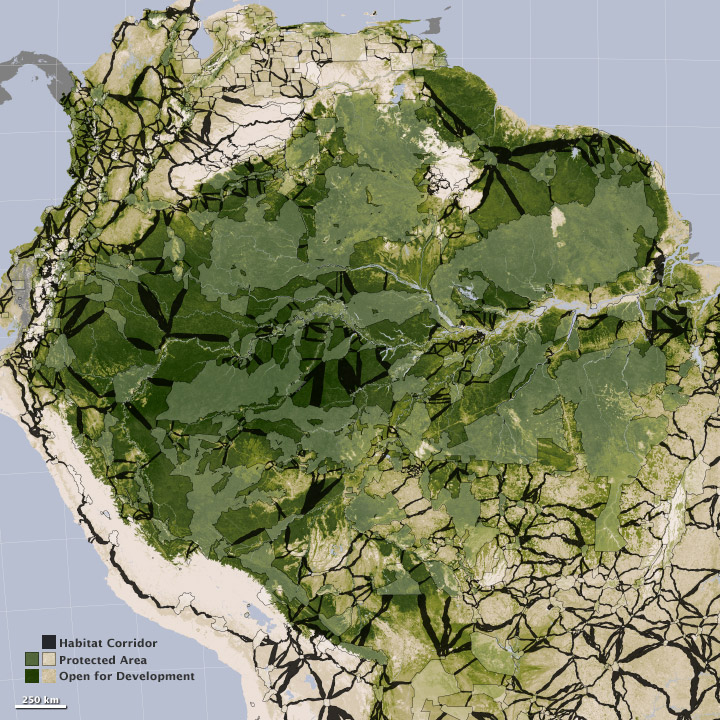
“To create the corridors, Jantz started with a tropical carbon map that Goetz, Laporte, Alessandro Baccini, and other WHRC scientists developed a few years ago. That map included data from NASA’s ICESat, Terra, and Aqua satellites, Japan’s ALOS satellite, the Shuttle Radar Topography Mission, and from thousands of ground-based observations. The tropical carbon map became the base layer on the map above.” Read more

NASA Earth Observatory image by Robert Simmon, using data from Patrick Jantz and Alessandro Baccini at Woods Hole Research Center. Caption by Mike Carlowicz.
Tagged with: ,