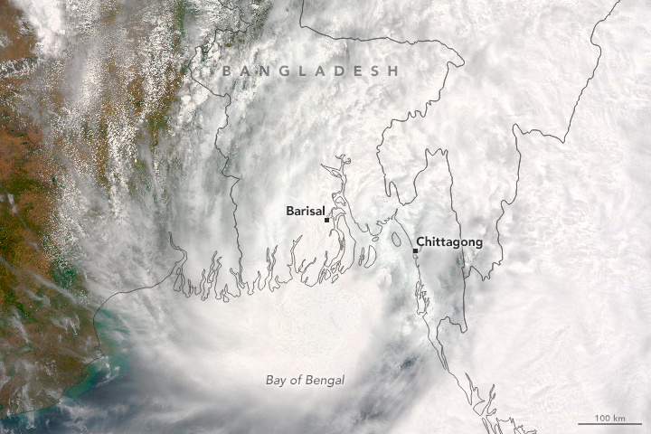
Tag: Weather

Weather News and Events

roanu_tmo_2016142

The Rains of Roanu

May 24, 2016 

Tropical Storm Roanu made landfall in Bangladesh, unleashing heavy winds and rain on the country’s populous coastal communities. On May 21, 2016, the Moderate Resolution Imaging Spectroradiometer (MODIS) on NASA’s Terra satellite acquired this natural-color image of the storm. Roanu progressed northeast over the Bay of Bengal before making landfall in Bangladesh.


beaufort_tmo_2014092-2016117

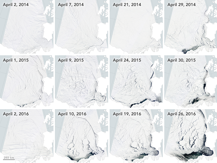
Early Breakup of the Beaufort Sea Ice 

May 20, 2016 

The Beaufort Sea ice pack starts to thin and break up in spring when temperatures begin to rise, usually in late May. However, much of the Beaufort Sea’s ice had already broken by mid-April. Images from the Moderate Imaging Spectroradiometer (MODIS) on NASA’s Terra satellite captured the progression in April in 2014, 2015, and 2016.


greenlandlsta_tmo_201604

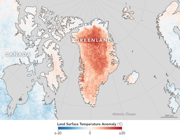
Widespread Warmth Envelops Greenland 

May 18, 2016

Land surface temperature data from the Moderate Imaging Spectroradiometer on NASA’s Terra satellite shows a much warmer than average April in Greenland.


canadalsta_tmo_2016126

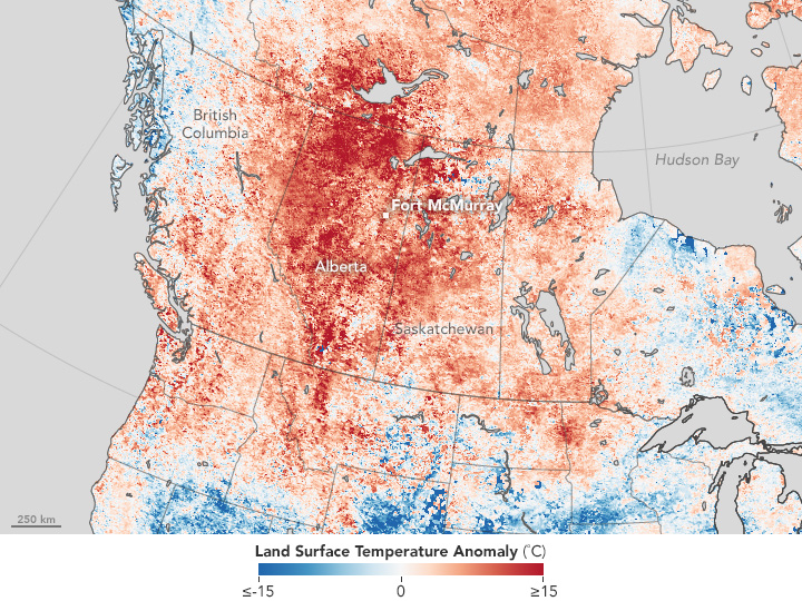
Heat Fuels Fire at Fort McMurray

May 7, 2016 

Land surface data from the Moderate Resolution Imaging Spectroradiometer showed increased land surface temperatures near Fort McMurray in Northern Alberta, Canada, where a destructive wildfire burned.


thailandlsta_tmo_201604

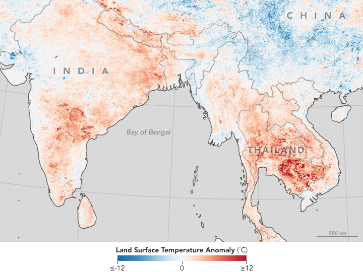
Heat Wave Hits Thailand, India

May 4, 2016

Land surface temperature map based on data from the Moderate Imaging Spectroradiometer on NASA’s Terra satellite shows a warmer than average Southeast Asia in April.

April 26, 2016

A Sudden Color Change on Lake KivuThe Moderate Imaging Spectroradiometer (MODIS) on NASA’s Terra Satellite captured images of a whiting event in Lake Kivu. The seasonal event is stronger this year, giving Lake Kivu a milky color. 


April 22, 2016

Using Clouds to Map Life – A team of researchers are using cloud data from the Moderate Imaging Spectroradiometer (MODIS) on NASA’s Terra Satellite to create detailed maps of cloud cover and variability. The team found that cloud cover could be an indicator and a better predictor of a songbird and flower’s range than temperature and precipitation.


April 17, 2016

Yellowstone National Park – Learn about Yellowstone National Park and view an image made possible by the Digital Elevation Model from the Advanced Spaceborne Thermal Emission and Reflection Radiometer (ASTER) on NASA’s Terra satellite.


April 14, 2016

Sierra Nevada Snowpack is Better, But not Normal – Snowpack in the Sierra Nevada mountains dwindled over recent years; however, the winter of 2015-2016 and the strong El Nino provided a thicker and more extensive snowpack. Regardless, snow levels in the Sierra Nevada mountains were still below average. Images from NASA’s Moderate Imaging Spectroradiometer (MODIS) clearly show the difference between years.


April 13, 2016

Antarctic Ice Shelf Sheds Bergs – The Moderate Imaging Spectroradiometer on NASA’s Terra Satellite captured this striking image of the formation of two new icebergs as they broke away from the Nansen Ice Shelf into the Southern Ocean on April 7, 2016.


April 9, 2016

Greening Ascension Island – When Charles Darwin first visited Ascension Island it was barren, but with the assistance of Joseph Hooker in the 1800s plants were introduced and now cover much of this once bleak island. The image from the Advanced Spaceborne Thermal Emissions and Reflection Radiometer (ASTER) on NASA’s Terra satellite shows the now green Ascension Island and it’s Green Mountain.


April 3, 2016

Pavlov Erupts Again – Pavlov Volcano, Alaska’s most active volcano, began erupting for the first time since November 2014. The Moderate Resolution Imaging Spectroradiometer (MODIS) instruments on NASA’s Terra and Aqua satellites acquired images of the ash plume at 11:45 a.m on March 28, 2016.

February 19, 2016
Ash Plume and Sea Ice Near Zhupanovsky – Since October, 2015 Zhupanovsky volcano in far eastern Russia has periodically been spewing ash into the atmosphere.  This MODIS image from February 13, 2016 shows an ash plume from Zhupanovsky volcano, which resulted in a code-red for air travel in the region.

Sea surface temperatures indicated that the warm "blob" has dissipated. NASA Earth Observatory image by Jesse Allen, using microwave and infrared multi-sensor SST data from Remote Sensing Systems.

February 12, 2016
The Demise of the Warm Blob – Ocean surface temperatures, showed a warm “blob” off the northern United State’s coast. This cell of warm ocean water in the Pacific Ocean no longer is present, having lasted from the winter of 2013 through December of 2015.

February 17, 2016
Waves Above and Below the Water – The Moderate Imaging Spectroradiometer on NASA’s Terra satellite acquired an image of wave patterns in the sky and in the water off the coast of Western Australia.

MODIS image of cloud streets over the Great Lakes.

February 11, 2016
Cloud Streets Over the Great Lakes – MODIS captured this image of cloud streets crossing the Great Lakes.

February 10, 2016
Snow in the Central U.S. – Snow from a blizzard blanketed parts of the Midwest. This image from Terra’s Moderate Imaging Spectroradiometer (MODIS) captured the snow that remained after the clouds cleared over Nebraska.

February 6, 2016
Open- and Closed-Celled Clouds over the Pacific – Terra’s Moderate Imaging Spectroradiometer (MODIS) captured in one image examples of two different types of convective clouds, open-celled and closed-celled.

February 5, 2016
Mount Erebus, Antarctica – Mount Erebus in Antarctica, thought to be the most southern volcano is still active. The Advanced Spaceborne Thermal Emissions and Reflection Radiometer (ASTER) on NASA’s Terra satellite captured images in visible and infrared, showing not just the volcano, but also the lava lake in its interior.

safricandvipa_tmo_201512

February 3, 2016
Drought in Southern Africa – Normalized Difference Vegetation Index (NDVI) data from Terra’s Moderate Imaging Spectroradiometer (MODIS) sensor are being used to track drought conditions in southern Africa, analyzing the effects of the current strong El Niño on vegetation.

The American Geophysical Union recently concluded its Fall meeting in San Fransisco, California from December 14 – 18, 2015.  As part of the meeting contributions to science were featured on NASA.gov.  Data from Terra’s instruments played important roles in collecting data to further research in each of these featured areas.  Read the full features from NASA.gov available at the links below.

El Niño

NASA: Observing the 2015 El Niño – The strongest El Niño since 1997 – 1998 is being monitored for the first time by a host of satellites, including Terra. This video (above) features global data sets from Terra’s instruments and their contribution to El Niño research.

How NASA Sees El Niño Effects From Space – The Moderate Imaging Spectroradiometer (MODIS) contributes to data collection on fires and hurricane monitoring

NASA Examines Global Impact of the 2015 El Niño – El Niño research pulls from data from Terra’s 16 years of data collection, monitoring Earth’s systems from Space

Warming Lakes
Study Shows Climate Change Rapidly Warming World’s Lakes – The Advanced Spaceborne Thermal Emission and Reflection Radiometer (ASTER) contributed to this study.

Earthquakes
Studies of Recent and Ancient Nepal Quakes Yield Surprises – The Advanced Spaceborne Thermal Emission and Reflection Radiometer (ASTER) contributed to this study.

20 November, 2015

turkey_Iraq_tmo_2015315

NASA Earth Observatory images by Joshua Stevens and Adam Voiland, using MODIS data from LANCE/EOSDIS Rapid Response and Landsat data from the U.S. Geological Survey.

Torrential rains in late October 2015 resulted in flooding in Iraq, prompting authorities to declare a state of emergency. Widespread power outages, overflowing sewers, and flooded streets displaced almost 84,000 people, according to news reports. The image from the Moderate Imaging Spectroradiometer (MODIS) on NASA’s Terra satellite, featured on NASA’s Earth Observatory, shows the flooding.

To see before and after images and read the whole article visit NASA’s Earth Observatory.