Month: April 2015

icebergb34_amo_2015064

NASA images by Jeff Schmaltz, LANCE/EOSDIS Rapid Response. Caption by Kathryn Hansen.

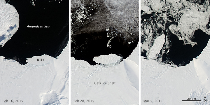
On March 6, 2015, the U.S. National Ice Center (NIC) discovered a new iceberg adrift off the coast of Antarctica. Measuring 27 kilometers (17 miles) long, iceberg B-34 meets the 19-kilometer minimum required for tracking by the NIC.

The berg appears to have fractured from West Antarctica’s Getz Ice Shelf and moved out into in the Amundsen Sea sometime in mid- to late-February 2015. The Moderate Resolution Imaging Spectroradiometer (MODIS) on NASA’s Terra and Aqua satellites acquired these images spanning the calving event. The first image (left) shows the iceberg on February 16, when it was still attached to the ice shelf. By February 28 (middle), it appears to have separated somewhat. By March 5 (right), it is floating freely. Read more

NASA Earth Observatory image (top) by Joshua Stevens using Landsat data from the U.S. Geological Survey and ASTER GDEM2 data from NASA/MITI and the ASTER Science Team.

NASA Earth Observatory image (top) by Joshua Stevens using Landsat data from the U.S. Geological Survey and ASTER GDEM2 data from NASA/MITI and the ASTER Science Team.

At approximately 6:45 a.m. on April 18, 2014, a block of ice tumbled from the edge of a hanging glacier onto a popular climbing route on the south face of Mount Everest. The ice, which weighed as much as 657 passenger buses, tumbled about 400 meters (1,300 feet) and triggered an avalanche. The falling ice and rock overwhelmed a group of Nepalese guides who were ferrying equipment from Base Camp (elevation 5,270 meters) to Camp 1 (elevation 6,035 meters) for foreign clients. Sixteen guides died in the avalanche, making it Everest’s deadliest day.

This three-dimensional rendering—made with data collected by the Operational Land Imager on Landsat 8 and the Advanced Spaceborne Thermal Emission and Reflection Radiometer (ASTER) on Terra—offers a broad view of the topography that climbers face. Read More

NASA image by Jeff Schmaltz, LANCE/EOSDIS Rapid Response. Caption by Kathryn Hansen.

NASA image by Jeff Schmaltz, LANCE/EOSDIS Rapid Response. Caption by Kathryn Hansen.

Spring and summer are the prime seasons for dust storms in China’s Taklimakan Desert. On April 1, 2015, the Moderate Resolution Imaging Spectroradiometer (MODIS) on NASA’s Terra satellite captured this natural-color image of dust from the desert and from the greater Tarim Basin.

The Tarim is bordered by the Tian Shan mountains to the north (obscured by clouds in this image) and the Kunlun Shan mountains to the south. The basin opens up on its east side, but that’s not necessarily an escape route for dust. The prevailing low-altitude winds come from the east, keeping most dust below 5 kilometers—about the height of the mountain ranges—and confined to the desert. Read more

ASTER_first_An_v2Fifteen years ago this month the Advanced Spaceborne Thermal Emission and Reflection Radiometer (ASTER) sensor onboard NASA’s Terra satellite began returning images. The first image from ASTER’s thermal infrared (TIR) subsystem was captured on March 3, 2000 of the western edge of the volcanic Afar Triangle in Ethiopia (see image to the right). This image represents not only ASTER’s first thermal image, but also the first high resolution multispectral thermal data collected by a sensor on a satellite. Since this first image 15 years ago, ASTER data has continued to be valuable to geologic and volcanic applications, as well as many other scientific disciplines.

Read the full article