Tag: Earth’s Surface and Interior

Earth’s Surface and Interior

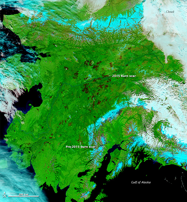
alaska_amo_2015244Alaska is experiencing it’s second most severe fire season since 1950 with over 5.2 million acres burned (the average is 800,000 acres per year).

Terra and Aqua Moderate Imaging Spectroradiometer (MODIS) are useful for scientists and land managers to be able to monitor and asses the environmental impact of remote forest fires.  This allows groups like the scientists from Universtity of California, Irvine, and Woods Hole Research Center to publish and analysis of carbon emissions for Alaska’s boreal forests. In addition land managing agencies are able to monitor fires unpopulated areas and allow them to burn, freeing up limited resources to be used in highly populated areas.


Read more on NASA’s Earth Observatory

turtlemnts_ast_2006139

Image courtesy NASA/GSFC/METI/ERSDAC/JAROS, and U.S./Japan ASTER Science Team. Caption by Adam Voiland.

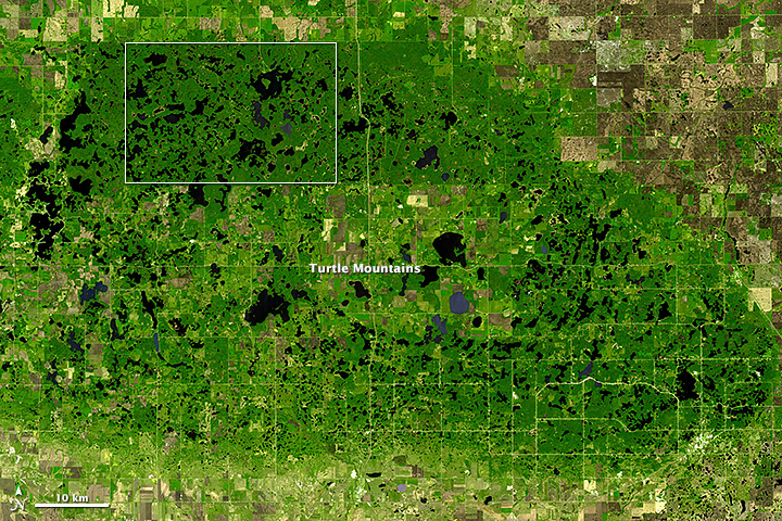
In most American states, the Turtle Mountains—which rise 600 to 800 feet (180 to 240 meters) above the surrounding plain—would be called hills. But in North Dakota, one of the flattest states, people have a habit of calling even relatively modest rises mountains. (In the past, the U.S. Board of Geographic Names argued that mountains should have at least 1,000 feet (300 meters) of local relief to earn the designation, but the group abandoned the argument for linguistic consistency in the 1970s.)

Whether hills or mountains, the hummocky highlands that straddle the border between North Dakota and southern Manitoba have enough elevation that they receive significantly more precipitation than the surrounding plains. As shown by this image from the Advanced Spaceborne Thermal Emission and Reflection Radiometer (ASTER) on NASA’s Terra satellite, enough moisture collects on the hills to support forests. The surrounding lowlands are a patchwork of grasslands and farms. In the lower image, a detailed view of a largely undeveloped part of Turtle Mountain Provincial Park, hundreds of ponds and lakes pockmark the landscape. A few roads and oil wells also appear. Read more

antikythera_ast_2013266

NASA Earth Observatory image by Jesse Allen, using data from NASA/GSFC/METI/ERSDAC/JAROS, and U.S./Japan ASTER Science Team. Caption by Kathryn Hansen.

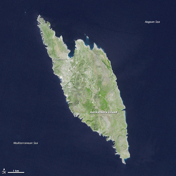
Crete is the largest and most populous Greek island, spanning 8,300 square kilometers (3,200 square miles) and supporting a population of 620,000. A short distance northwest of Crete is a lesser-known Greek island, Antikythera. The island is comparatively tiny, spanning just 20 square kilometers (8 square miles) and supporting a human population that hovers around 50.

This view of Antikythera was acquired on September 23, 2013, by the Advanced Spaceborne Thermal Emission and Reflection Radiometer (ASTER) on the Terra satellite. The landscape is typical of a small Mediterranean island, consisting primarily of open countryside and low shrubs. Steep, limestone cliffs line most of the island; flatter expanses of beach are more common on Kythira, a larger Greek island to the north. Read more

wolf_ast_2015162

NASA Earth Observatory image by Jesse Allen, using data from NASA/GSFC/METI/ERSDAC/JAROS, and U.S./Japan ASTER Science Team. Caption by Mike Carlowicz.

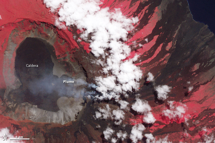
In late May 2015, the highest volcano in the Galapagos Islands erupted for the first time in 33 years. The explosive eruption at Wolf volcano on Isabela Island sent volcanic gases and ash roughly 15 kilometers (50,000 feet) into the sky, while lava flowed through a fissure, down eastern and southeastern slopes, and eventually reached the sea. In early June, the sulfur-rich lava flows on the slopes appeared to subside.

The wide image and closeup of Wolf was acquired on June 11, 2015, by the Advanced Spaceborne Thermal Emission and Reflection Radiometer (ASTER) on the Terra satellite. The false-color images combine near-infrared, red, and green light (ASTER bands 3-2-1), with vegetated areas appearing in red and lava generally appearing charcoal or black. Note, however, the infrared (IR) image on the top right, where the heat signature of the freshly placed lava appears as white streaks. (The image is smaller because the sensor has lower resolution.) Read more

shasta_ast_2014245

NASA Earth Observatory images by Joshua Stevens, using data from NASA/GSFC/METI/ERSDAC/JAROS, and U.S./Japan ASTER Science Team. Caption by Kathryn Hansen.

The ongoing drought in the western United States is evident in the water levels of Shasta Lake, a large reservoir in northern California that counts on rainfall for replenishment. Low water levels can lead to hazardous conditions for local recreation. Many more people are affected by how this limited water resource is allocated for ecological, urban, and agricultural needs downstream.

The Advanced Spaceborne Thermal Emission and Reflection Radiometer (ASTER) on Terra acquired these simulated true-color images of Shasta Lake. The top image shows the lake on September 14, 2005, and the bottom image was acquired on September 2, 2014. Read more