Tag: Atmosphere

Atmosphere News and Events

RedSea_tmo_2014189

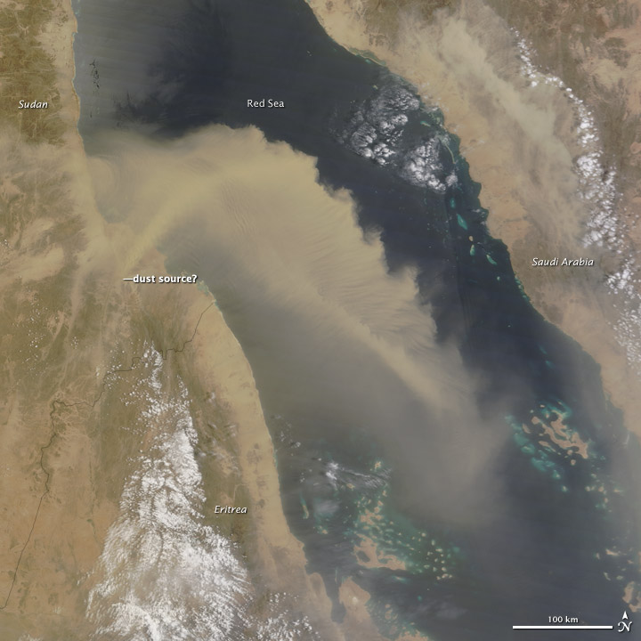
Dust and sand storms are not unusual in North Africa and western Asia; in fact, they are a regular part of the region’s rhythm and observed often by satellites. But familiarity does not make them any less extraordinary.

The Moderate Resolution Imaging Spectroradiometer (MODIS) on NASA’s Terra satellite captured this image at 11:25 a.m. local time (0825 Universal Time) on July 7, 2014. A thick plume of dust was blowing out from the dry interior of Sudan and across hundreds of kilometers of the Red Sea, with smaller plumes also visible over Saudi Arabia and Eritrea. Prevailing northwest winds over the water blew the plumes to the southeast. Read more

NASA image courtesy Jeff Schmaltz, LANCE/EOSDIS MODIS Rapid Response Team at NASA GSFC. Caption by Mike Carlowicz.

indonesia_tmo_2014151

Due to elevated seismic activity, the Volcanological Survey of Indonesia issued an alert for Sangeang Api—an island volcano in the Flores Sea—on May 21, 2014. Sangeang erupted explosively on May 30, sending a thick column of ash and sulfur dioxide billowing into the atmosphere.

The Moderate Resolution Imaging Spectroradiometer (MODIS) aboard the Terra satellite captured imagery of the eruption plume the next day. Terra acquired this image at 2:35 UTC (10:35 a.m. local time) on May 31, 2014. Ash drifted southeast, shutting down airports in Bima, Indonesia, and Darwin, Australia. Service to Darwin resumed by June 1, but Bima remained shut down as of June 2, according to the Jakarta Globe. Read more

NASA image courtesy Jeff Schmaltz LANCE/EOSDIS MODIS Rapid Response Team, GSFC. Caption by Adam Voiland.


NASA images courtesy Jeff Schmaltz, LANCE/EOSDIS MODIS Rapid Response Team at NASA GSFC. Caption by Holli Riebeek.

A wall of dust was barreling across northern China on April 23, 2014, when the Moderate Resolution Imaging Spectroradiometer (MODIS) acquired these images from NASA’s Aqua and Terra satellites. The top image was taken at 12:35 p.m. local time, and the lower image is from 2:20 p.m. Turn on the image comparison tool to see how far the dust advanced in the two hours between images. Read more

NASA images courtesy Jeff Schmaltz, LANCE/EOSDIS MODIS Rapid Response Team at NASA GSFC. Caption by Holli Riebeek.

NASA image courtesy Jeff Schmaltz, LANCE/EOSDIS MODIS Rapid Response Team at NASA GSFC. Caption by Holli Riebeek.

Air flows like water in the atmosphere with invisible currents and waves. On April 9, 2014, the Moderate Resolution Imaging Spectroradiometer (MODIS) on NASA’s Terra satellite captured this view that evokes fluid-like movement in the atmosphere. Ship wave clouds fan out behind the Crozet Islands over the southern Indian Ocean looking exactly like the ripples behind a rock in a stream or the waves behind a boat moving through calm water. Read more

NASA image courtesy Jeff Schmaltz, LANCE/EOSDIS MODIS Rapid Response Team at NASA GSFC. Caption by Holli Riebeek.

NASA image courtesy LANCE/EOSDIS MODIS Rapid Response Team at NASA GSFC. Caption by Holli Riebeek.

High winds propelled a wildfire through parts of Valparaiso, Chile, on April 13, 2014. It quickly became the largest fire in the history of this port city. The fire started in a forested area on April 12 and eventually reached wooden homes built on steep hills around the city. According to news reports, at least 12 people died, 2,000 homes were destroyed, and about 10,000 people evacuated as the fire moved through a section of the historic city.

The Moderate Resolution Imaging Spectroradiometer (MODIS) on NASA’s Terra satellite acquired this image of the fire at 11:10 am local time (14:10 UTC) on April 13. Fire detections are outlined in red in the forest south of the city, which is pale gray. A long plume of smoke stretches northwest over the Pacific Ocean, a clear indication that winds were strong and blowing the flames toward the city. Read more

NASA image courtesy LANCE/EOSDIS MODIS Rapid Response Team at NASA GSFC. Caption by Holli Riebeek.