Month: August 2014

Canada_tmo_2014188_detail


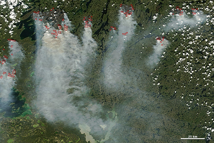
A combination of lightning and dry forests fueled numerous wildfires in Canada’s Northwest Territories in July 2014. The fires, burning in Canada’s boreal zone, are producing dense smoke. As of July 8, at least 164 blazes had charred more than 425,172 hectares (1,642 square miles), according to the Canadian government. The fires destroyed one home, forced hundreds of people to evacuate, and sent smoke drifting as far south as the continental United States.

The Moderate Resolution Imaging Spectroradiometer (MODIS) on NASA’s Terra satellite captured this image of smoke billowing from wildfires near Faber Lake on July 7, 2014. Read more

NASA image courtesy Jeff Schmaltz, LANCE/EOSDIS MODIS Rapid Response Team at NASA GSFC. Caption by Adam Voiland.


neoguri_tmo_2014190

Typhoon Neoguri pounded Okinawa and other Western Pacific islands with torrential rain and damaging winds in mid-July 2014, en route to a likely landfall in Japan. The Visible Infrared Imaging Radiometer Suite (VIIRS) on the Suomi NPP satellite captured a nighttime image of the storm at 2:07 a.m. Japan Standard Time on July 9, 2014 (17:07 Universal Time on July 8). At the time, Neoguri was a category 2 typhoon moving through the East China Sea.

The storm was imaged by a special “day-night band” that detects light in a range of wavelengths from green to near-infrared and uses light intensification to detect dim signals. The instrument can sense light as much as 100,000 times fainter than conventional visible-light sensors, making it very sensitive to moonlight and city lights. In this case, the cloud tops were lit by the nearly full Moon.

The Moderate Resolution Imaging Spectroradiometer (MODIS) on NASA’s Terra satellite captured a natural-color image of Neoguri at 11:30 a.m. local time (0230 Universal Time) on July 9, 2014. Read more

Terra MODIS image by Jeff Schmaltz, LANCE/EOSDIS Rapid Response. Caption by Michael Carlowicz.

pilger_ast_2014172

On June 16, 2014, a tornadic thunderstorm system moved across portions of northeast Nebraska, producing 5 tornadoes. Four of the tornadoes were rated as EF-4 on the Enhanced Fujita Scale, meaning that they were violent tornadoes with winds between 166 and 200 miles per hour. One EF-4 tornado spun directly through Pilger, Nebraska, a small town of 350 people, leveling much of the town.

The Advanced Spaceborne Thermal Emission and Reflection Radiometer (ASTER) instrument aboard NASA’s Terra satellite captured the top image of northeast Nebraska on June 21, 2014. Two of the EF-4 tornado tracks are visible in the false-color image (near-infrared, red, green). The tracks are tan paths of bare ground across plant-covered fields, which are red. The towns of Pilger and Wisner are bright white. The lower image, also from the ASTER instrument, shows the region on July 4, 2013. Turn on the comparison tool to contrast the before and after views. Read more

NASA Earth Observatory image by Jesse Allen, using data from NASA/GSFC/METI/ERSDAC/JAROS, and U.S./Japan ASTER Science Team. Caption by Kari Beckendorf and Holli Riebeek.

india_lsta_20140602-09

In the first half of June 2014, news accounts described an extreme heatwave in India, as well as the late and somewhat weak arrival of the seasonal monsoon. Air temperatures in New Delhi climbed as high as 48° Celsius (118° Fahrenheit) and stayed above 43°C (110°F) for seven days. Satellite data offer some insights on what was happening on the ground.

The maps above show land surface temperature (LST) anomalies for southern Asia from June 2–9 and June 10–17, 2014. LST anomalies are not absolute temperatures; instead, they show how much the land surface was heated above or below the average. The darkest reds show areas where the ground was as much as 12°C (22°F) above the norm from 2001–2010; blues show areas that were below normal; and grays depicts areas with incomplete data (usually due to excessive cloud cover). Read more

Parana_tmo_2014162

Torrential rain brought deadly floods to southern Brazil and Paraguay in June 2014. The top image, acquired by the Moderate Resolution Imaging Spectroradiometer (MODIS) on NASA’s Terra satellite on June 11, 2014, shows flooding in the Paraná River system in Brazil’s Paraná state. The Ivaí, Piquiri, and Paraná rivers are all swollen and muddy from runoff. The lower image, acquired by Terra MODIS on June 12, 2012, shows the river system in non-flood conditions. Turn on the image comparison tool to see the extent of the flooding. Read more

NASA image courtesy LANCE/EOSDIS MODIS Rapid Response Team at NASA GSFC. Caption by Holli Riebeek.