Month: August 2014

cristina_tmo_2014163

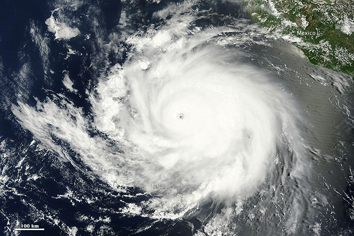
When the Moderate Resolution Imaging Spectroradiometer (MODIS) on NASA’s Aqua satellite acquired this image at 10:40 a.m. local time (17:40 Universal Time) on June 12, 2014, Tropical Cyclone Cristina was churning over the eastern Pacific Ocean off the coast of Mexico. The storm had maximum sustained winds near 240 kilometers (150 miles) per hour, making it the equivalent of a category 4 hurricane. The storm was moving west-northwest at a speed of 13 kilometers (8 miles) per hour. Read more

NASA image courtesy of the LANCE/EOSDIS MODIS Rapid Response Team at NASA GSFC. Caption by Adam Voiland.

california_tmo_2011017

From time to time, in the wake of winter rain, dense fog fills the wide valley between California’s Sierra Nevada and Coastal Range. Called Tule fog, the phenomenon is as much a part of winter in the Central Valley as snow is in the mountain. In recent years, however, the fog has come less often. In fact, since 1981 the number of fog days between November and February has decreased by 46 percent, according to a recent study. The decrease is bad news for California’s fruit and nut farmers.

This image, acquired on January 17, 2011, by the Moderate Resolution Imaging Spectroradiometer (MODIS) on NASA’s Terra satellite, shows one of the more recent valley fog events. (Drought has limited the number of fog events since 2012.) University of California–Berkeley researchers Dennis Baldocchi and Eric Waller used images from MODIS and from NOAA’s advanced very high resolution radiometer (AVHRR) to count the number of fog days since 1981. They found a downward trend. Read more

NASA Earth Observatory image by Jesse Allen with data from the Land Atmosphere Near real-time Capability for EOS (LANCE). Caption by Holli Riebeek.

indonesia_tmo_2014151

Due to elevated seismic activity, the Volcanological Survey of Indonesia issued an alert for Sangeang Api—an island volcano in the Flores Sea—on May 21, 2014. Sangeang erupted explosively on May 30, sending a thick column of ash and sulfur dioxide billowing into the atmosphere.

The Moderate Resolution Imaging Spectroradiometer (MODIS) aboard the Terra satellite captured imagery of the eruption plume the next day. Terra acquired this image at 2:35 UTC (10:35 a.m. local time) on May 31, 2014. Ash drifted southeast, shutting down airports in Bima, Indonesia, and Darwin, Australia. Service to Darwin resumed by June 1, but Bima remained shut down as of June 2, according to the Jakarta Globe. Read more

NASA image courtesy Jeff Schmaltz LANCE/EOSDIS MODIS Rapid Response Team, GSFC. Caption by Adam Voiland.


Peru_tmo_2014148

Ocean clouds meet the coastal desert in dramatic fashion on the coast of Peru, outlining the inland topography with precision. This image, acquired by the Moderate Resolution Imaging Spectroradiometer (MODIS) on NASA’s Terra satellite on May 28, 2014, illustrates the balance of nature’s extremes: dry versus wet and high versus low. Read more

NASA image courtesy Jeff Schmaltz, LANCE/EOSDIS MODIS Rapid Response Team at NASA GSFC. Caption by Holli Riebeek.