Tag: Weather

Weather News and Events

NASA images courtesy Jeff Schmaltz, LANCE/EOSDIS MODIS Rapid Response Team at NASA GSFC. Caption by Holli Riebeek.

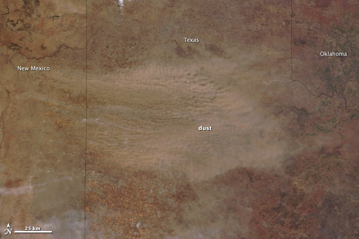
A low-pressure system brought strong winds—gusting to 55 miles (85 kilometers) per hour—to the Southern Plains on March 18, 2014. The winds picked up exposed soil from the parched landscape, resulting in a large dust storm that covered parts of Colorado, Kansas, Oklahoma, New Mexico, and Texas. The storm was the second in the past week to sweep across the region with similar wind patterns.

The Moderate Resolution Imaging Spectroradiometer (MODIS) acquired this image of the storm on March 18. The top image shows the dust over the Texas Panhandle at 1:15 p.m. Central Daylight Time from the MODIS instrument on NASA’s Terra satellite. Read more

NASA images courtesy Jeff Schmaltz, LANCE/EOSDIS MODIS Rapid Response Team at NASA GSFC. Caption by Holli Riebeek.

NASA image courtesy Jeff Schmaltz, LANCE/EOSDIS MODIS Rapid Response Team at NASA GSFC. Caption by Holli Riebeek.

When the winds of winter sweep across West Africa, temperatures drop and skies turn yellow. Prevalent from November to March, the harmattan is a desert wind that blows across the Sahara Desert from the northeast or the east, usually as a result of a high pressure system over the northwestern Sahara. Harmattan winds pick up dust and darken skies.

A harmattan dust storm was blowing on February 28, 2014, when the Moderate Resolution Imaging Spectroradiometer (MODIS) on NASA’s Terra satellite acquired this image. The yellow dust was concentrated largely over the Cape Verde Islands, where the mountain topography created swirling eddies and triangular wakes in the dust cloud. West Africa frames the right edge of the image, and distinct plumes of dust moved west from Senegal and Mauritania. Read more

NASA image courtesy Jeff Schmaltz, LANCE/EOSDIS MODIS Rapid Response Team at NASA GSFC. Caption by Holli Riebeek.

NASA Earth Observatory images by Jesse Allen, using data provided by George Riggs and Dorothy Hall (NASA/GSFC). Caption by Holli Riebeek.

Nature helped the Olympic hosts in 2014 with cold weather and some natural snow in the weeks prior to the games. This map shows the extent of snow in the region on February 3, 2014.

The map was made with data from the Moderate Resolution Imaging Spectroradiometer (MODIS) on NASA’s Terra satellite and matches the natural color image. Unlike the natural color image, the snow map differentiates between snow and cloud, and between land that is entirely covered in snow, and land where snow cover is patchy. Krasnaya Polyana, the town at the base of mountain where Rosa Khutor is located, has little to no snow, but the nearby slopes appear to be mostly snow covered. Sochi is snow free. Read more at Earth Observatory.

NASA Earth Observatory images by Jesse Allen, using data provided by George Riggs and Dorothy Hall (NASA/GSFC). Caption by Holli Riebeek.

NASA Earth Observatory image by Jesse Allen, using data from the Level 1 and Atmospheres Active Distribution System (LAADS). Caption by Holli Riebeek.

2013 turned out to be Australia’s hottest year on record. Fittingly, the calendar year both started and ended with intense heat waves. The most recent heat wave peaked between December 27, 2013, and January 4, 2014. The heat raised land surface temperatures (LSTs) that are monitored by the Moderate Resolution Imaging Spectroradiometer (MODIS) on NASA’s Terra satellite. Read more

NASA Earth Observatory image by Jesse Allen, using data from the Level 1 and Atmospheres Active Distribution System (LAADS). Caption by Holli Riebeek.

NASA image courtesy EOSDIS Worldview at NASA GSFC. Caption by Holli Riebeek.

A rare winter storm dropped snow across much of the Middle East between December 10 and 13, 2013. The Moderate Resolution Imaging Spectroradiometer (MODIS) on NASA’s Terra satellite acquired this image of the snow on December 15 after the clouds cleared. For the most part, the snow is confined to higher elevations in Syrian, Egypt, Lebanon, Israel and West Bank, and Jordan. Some lower-elevation desert regions in Syria are snowy. Read more

NASA image courtesy EOSDIS Worldview at NASA GSFC. Caption by Holli Riebeek.