Tag: MODIS

MODIS News and Events

NASA Earth Observatory image by Jesse Allen, using data from the Level 1 and Atmospheres Active Distribution System (LAADS). Caption by Holli Riebeek.

A deadly heatwave left its signature on the land in Argentina. This map shows land surface temperatures between December 19-26, 2013, compared to average temperatures for the same period from 2000-2012. Nearly the entire country was much warmer than normal, with some locations more than 15°Celsius above average.

Argentina was in the midst of an intense two-week heatwave when the data for the map was acquired by the Moderate Resolution Imaging Spectroradiometer (MODIS) on NASA’s Terra satellite. Read more

NASA Earth Observatory image by Jesse Allen, using data from the Level 1 and Atmospheres Active Distribution System (LAADS). Caption by Holli Riebeek.

NASA Earth Observatory images by Jesse Allen and Robert Simmon, using data from LANCE/EOSDIS Rapid Response. Caption by Adam Voiland.

On January 6, 2014, the Moderate Resolution Imaging Spectroradiometer MODIS on NASA’s Terra satellite captured this natural-color image (top) of fog forming over the lakes and streaming southeast with the wind.  A swirling mass of Arctic air moved south into the continental United States in early January 2014. On January 3, the air mass began breaking off from the polar vortex, a semi-permanent low-pressure system with a center around Canada’s Baffin Island. The frigid air was pushed south into the Great Lakes region by the jet stream, bringing abnormally cold temperatures to many parts of Canada and the central and eastern United States. Read more

NASA Earth Observatory images by Jesse Allen and Robert Simmon, using data from LANCE/EOSDIS Rapid Response. Caption by Adam Voiland.

Terra is now well into her teenage years, but is by no means setting records for the longest operating satellite.  In fact, Terra has only been collecting data half as long as Landsat 5, which set the record for longest operating satellite last year after operating for 28 years and 10 months.  Terra has surpassed its intended design life by 8 years, but it is still collecting meaningful data, giving scientists insight into how different systems on Earth effect each other.

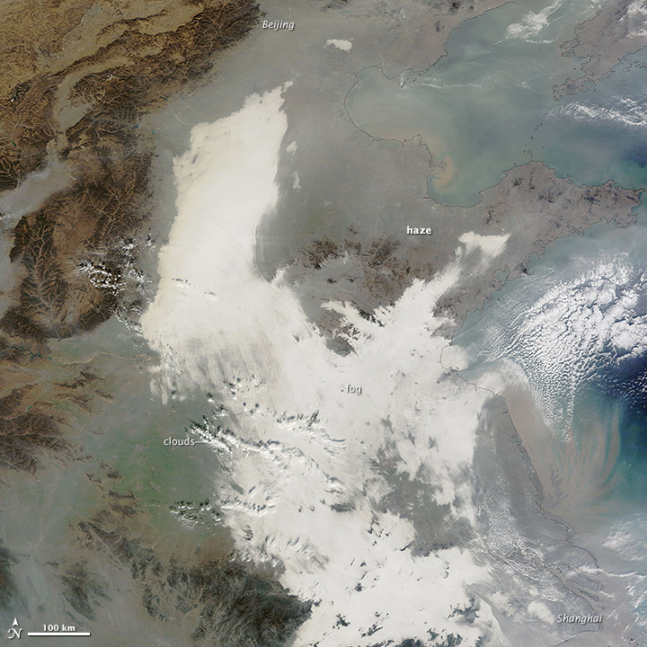
Beyond Terra’s contributions to scientific research, it continues to help monitor forest fires, equipping land managing agencies with the ability to track a fire’s progress and identify areas of concern.  Terra also continues to witness phytoplankton blooms, monitor changes in ice shelves, witness volcanic eruptions, and track dust, haze and smog as it travels from its source. Terra is improving climate and weather models, helping forecasters make better predictions.

In addition to Terra’s scientific and climate contributions, it continues to showcase how the United States in partnership with other countries, like Japan and Canada, can work together to increase knowledge and gain a better understanding of Earth’s varying climate and the interconnectedness of Earth’s systems. Since Terra’s launch, other satellites such as the Global Precipitation Measurement (GPM), expected to launch in 2014, have followed Terra’s lead by partnering with other countries to provide scientist’s with a wide array of information to better understand Earth.


NASA image courtesy EOSDIS Worldview at NASA GSFC. Caption by Holli Riebeek.

A rare winter storm dropped snow across much of the Middle East between December 10 and 13, 2013. The Moderate Resolution Imaging Spectroradiometer (MODIS) on NASA’s Terra satellite acquired this image of the snow on December 15 after the clouds cleared. For the most part, the snow is confined to higher elevations in Syrian, Egypt, Lebanon, Israel and West Bank, and Jordan. Some lower-elevation desert regions in Syria are snowy. Read more

NASA image courtesy EOSDIS Worldview at NASA GSFC. Caption by Holli Riebeek.

Chinahaze_tmo_2013341

China suffered another severe bout of air pollution in December 2013. When the Moderate Resolution Imaging Spectroradiometer (MODIS) on NASA’s Terra satellite acquired this image on December 7, 2013, thick haze stretched from Beijing to Shanghai, a distance of about 1,200 kilometers (750 miles). For comparison, that is about the distance between Boston, Massachusetts, and Raleigh, North Carolina. The brightest areas are clouds or fog. Polluted air appears gray. While northeastern China often faces outbreaks of extreme smog, it is less common for pollution to spread so far south. Read more

NASA image courtesy Jeff Schmaltz, LANCE MODIS Rapid Response. Caption by Adam Voiland.