Image from TERRA
Tue, 18 Apr 2023 16:24 EDT

The Valley of Ten Thousand Smokes, located in Katmai National Park, forms a unique and ashen landscape. Encircled by volcanoes – both active and inactive – it has served as a perfect collection area for huge amounts of volcanic ash.

Image from TERRA
Tue, 20 Sep 2022 10:30 EDT

Water departments in the West are using maps and models originally created by a NASA team to help track water.

Image from TERRA
Thu, 15 Sep 2022 10:00 EDT

NASA and Google broadened an existing partnership to help local governments improve their monitoring and prediction of air quality for better decision making.

Heat Wave in Argentina

NASA Earth Observatory image by Jesse Allen, using data from the Level 1 and Atmospheres Active Distribution System (LAADS). Caption by Holli Riebeek.

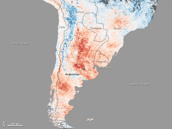
A deadly heatwave left its signature on the land in Argentina. This map shows land surface temperatures between December 19-26, 2013, compared to average temperatures for the same period from 2000-2012. Nearly the entire country was much warmer than normal, with some locations more than 15°Celsius above average.

Argentina was in the midst of an intense two-week heatwave when the data for the map was acquired by the Moderate Resolution Imaging Spectroradiometer (MODIS) on NASA’s Terra satellite. Read more

NASA Earth Observatory image by Jesse Allen, using data from the Level 1 and Atmospheres Active Distribution System (LAADS). Caption by Holli Riebeek.
Tagged with: ,