Tag: MODIS

MODIS News and Events

      NASA Earth Observatory images by Jesse Allen, using MODIS data from the Land Processes Distributed Active Archive Center (LPDAAC). Caption by Michael Carlowicz.

For many residents of North America, the winter of 2013-14 has felt like one of the coldest in many years. Waves of Arctic air brought extended periods of cold weather and above-average snowfall to the middle and eastern portions of the United States and Canada. Seven Midwestern states had one of their top-ten coldest winters, and the Great Lakes were chilled until they reached nearly 91 percent ice cover. Even portions of Mexico and Central America were cooler than normal. Read More

NASA Earth Observatory images by Jesse Allen, using MODIS data from the Land Processes Distributed Active Archive Center (LPDAAC). Caption by Michael Carlowicz.

NASA images courtesy Jeff Schmaltz, LANCE/EOSDIS MODIS Rapid Response Team at NASA GSFC. Caption by Holli Riebeek.

A low-pressure system brought strong winds—gusting to 55 miles (85 kilometers) per hour—to the Southern Plains on March 18, 2014. The winds picked up exposed soil from the parched landscape, resulting in a large dust storm that covered parts of Colorado, Kansas, Oklahoma, New Mexico, and Texas. The storm was the second in the past week to sweep across the region with similar wind patterns.

The Moderate Resolution Imaging Spectroradiometer (MODIS) acquired this image of the storm on March 18. The top image shows the dust over the Texas Panhandle at 1:15 p.m. Central Daylight Time from the MODIS instrument on NASA’s Terra satellite. Read more

NASA images courtesy Jeff Schmaltz, LANCE/EOSDIS MODIS Rapid Response Team at NASA GSFC. Caption by Holli Riebeek.

NASA image courtesy Jeff Schmaltz, LANCE/EOSDIS MODIS Rapid Response Team at NASA GSFC. Caption by Holli Riebeek.

When the winds of winter sweep across West Africa, temperatures drop and skies turn yellow. Prevalent from November to March, the harmattan is a desert wind that blows across the Sahara Desert from the northeast or the east, usually as a result of a high pressure system over the northwestern Sahara. Harmattan winds pick up dust and darken skies.

A harmattan dust storm was blowing on February 28, 2014, when the Moderate Resolution Imaging Spectroradiometer (MODIS) on NASA’s Terra satellite acquired this image. The yellow dust was concentrated largely over the Cape Verde Islands, where the mountain topography created swirling eddies and triangular wakes in the dust cloud. West Africa frames the right edge of the image, and distinct plumes of dust moved west from Senegal and Mauritania. Read more

NASA image courtesy Jeff Schmaltz, LANCE/EOSDIS MODIS Rapid Response Team at NASA GSFC. Caption by Holli Riebeek.

NASA Earth Observatory image by Jesse Allen, using data from the Land Atmosphere Near real-time Capability for EOS (LANCE). Caption by Adam Voiland.

Soggy winters are not unusual in the United Kingdom, but this winter has been in a category of its own. UK Met Office meteorologists had just declared January 2014 the wettest month on record for parts of southern Britain when another series of storms swept across the area in early February.

The Moderate Resolution Imaging Spectroradiometer (MODIS) on NASA’s Terra satellite captured this image of an extratropical cyclone bearing down on the United Kingdom on February 12, 2014. Mature extratropical cyclones often feature comma-shaped cloud patterns that are the product of “conveyor belt” circulation. While heavy precipitation is often present near the low-pressure head of the comma, a slot of dry air usually trails the west side of the tail. Read more

NASA Earth Observatory image by Jesse Allen, using data from the Land Atmosphere Near real-time Capability for EOS (LANCE). Caption by Adam Voiland.

NASA Earth Observatory image by Jesse Allen, Earth Observatory, using data provided by Inbal Reshef, Global Agricultural Monitoring Project. Caption by Mike Carlowicz.

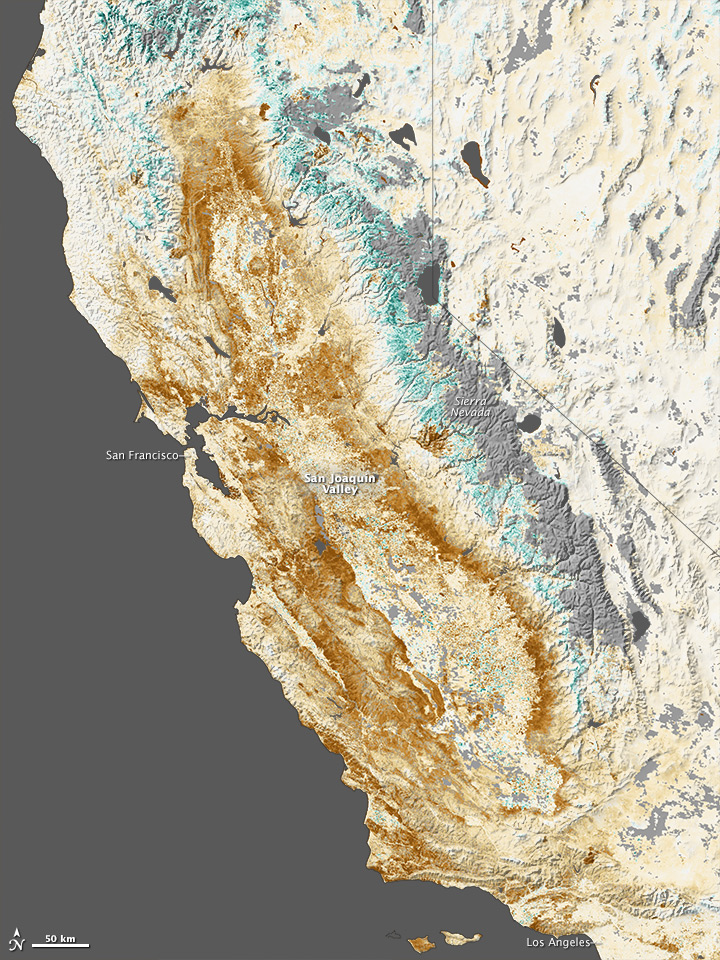
Persistent dry weather has grown more worrisome in the American West, with nearly two thirds of the region experiencing some level of drought. By most measures, the state of California is suffering through the worst of it. The effects of the dry spell are visible in the mountains, where snow pack is lacking, and now in the vegetation cover on the landscape. Nearly all of California was in a state of extreme drought at the end of January 2014. The past three months (November to January), six months (since August) and twelve months were all the driest periods in California since record-keeping started in 1885. From February 1, 2013, through January 31, 2014, a statewide average of 6.97 inches (177.04 millimeters) of rain fell; the norm is 22.51 inches (571.75 millimeters). The map above shows the impact of drought on California’s farms, forests, and wild lands. Based on data from the Moderate Resolution Imaging Spectroradiometer (MODIS) on NASA’s Terra and Aqua satellites, the map contrasts plant health from January 17 to February 1, 2014, against average conditions for the same period over the past decade. Read more

NASA Earth Observatory image by Jesse Allen, Earth Observatory, using data provided by Inbal Reshef, Global Agricultural Monitoring Project. Caption by Mike Carlowicz.