Tag: MODIS

MODIS News and Events

Hagupit_tmo_2014338

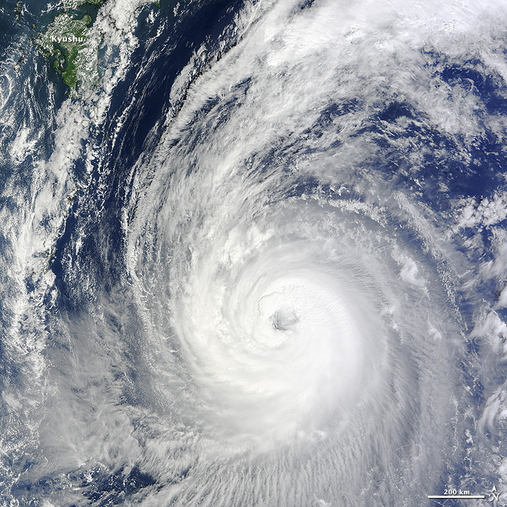
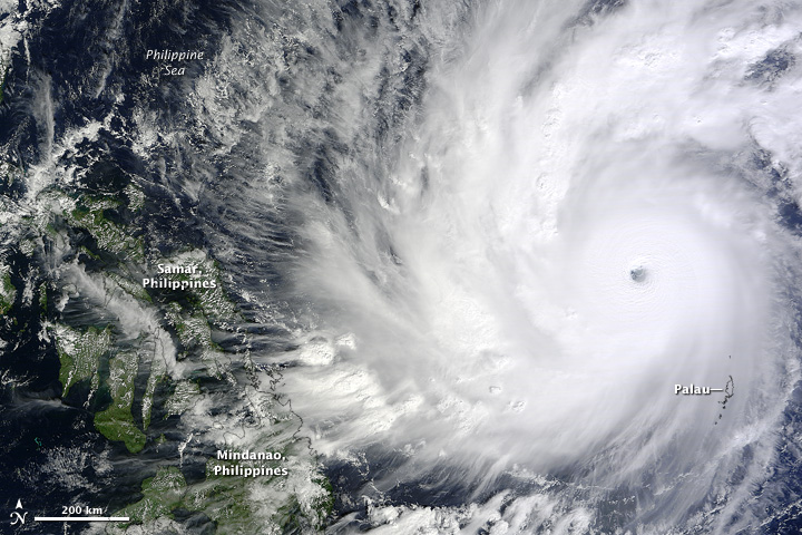
The twenty-second tropical weather system (and eleventh typhoon) of the year in the Western Pacific Ocean had the potential to be one of the most damaging of 2014. In early December, Hagupit approached The Philippines as a major and slow-moving typhoon that threatened to hit the islands with torrential rain and a large storm surge. Hundreds of thousands of people were evacuated in the lead-up to the storm on December 5.

The Moderate Resolution Imaging Spectroradiometer (MODIS) on NASA’s Terra satellite acquired this image at 11:20 a.m. Palau time (0210 Universal Time) on December 4, 2014. At the time, Hagupit was a category 5 super typhoon with sustained winds of 155 knots (180 miles or 290 kilometers per hour). It was the fourth category 5 typhoon of the year in the Western Pacific.

read more

australia_tmo_2014280

NASA image courtesy Jeff Schmaltz, LANCE MODIS Rapid Response Team at NASA GSFC. Caption by Adam Voiland, with information from Daniel Lindsey (NOAA) and Rick McRae (Australian Capital Territory Emergency Services Agency).

The intense bushfires that strike southern Australia in the summer usually attract the most headlines, but the country’s largest and most frequent blazes actually occur in northern Australia in the spring. In fact, in terms of sheer area burned, satellite observations show that over 98 percent of large fires in Australia occur well outside of densely populated southeastern and southwestern parts of the country.

A fire that began burning in Northern Territory on September 10, 2014, offers a prime example of just how expansive fires from this part of the continent can become. After racing through grasslands for just a few weeks, the fire had charred an area about the size of Massachusetts by October 8, 2014.

The Moderate Resolution Imaging Spectroradiometer (MODIS) on NASA’s Terra satellite captured this sequence of images showing the progression of the fire.  Read more

phanfone_tmo_2014276

NASA image by Jeff Schmaltz, LANCE/EOSDIS Rapid Response. Caption by Kathryn Hansen.

Forecasts indicate that Japan can expect widespread rain as Typhoon Phanfone nears the nation over the weekend. The Moderate Resolution Imaging Spectroradiometer (MODIS) on NASA’s Terra satellite acquired this natural-color view of the category 3 storm at 10:55 a.m. Japan Standard Time (01:55 Universal Time) on October 3, 2014. Read more


GreatLakes_tmo_2014269

NASA image courtesy Jeff Schmaltz, LANCE MODIS Rapid Response Team at NASA GSFC. Caption by Mike Carlowicz.

A few days after autumn showed up on the calendar in the Northern Hemisphere, it showed up on the landscape of North America. The Moderate Resolution Imaging Spectroradiometer (MODIS) on NASA’s Terra satellite captured these views of fall colors around the Great Lakes (September 26) and New England (September 27, 2014). The brown and orange shades are most pronounced in the Upper Peninsula of Michigan, northern Wisconsin, upstate New York, New Hampshire, Vermont, Maine, and southern Quebec and Ontario. You can also see faint traces of phytoplankton blooms in the lakes and offshore in the North Atlantic.

The changing of leaf color in temperate forests involves several causes and reactions, but the dominant factors are sunlight and heat. Since temperatures tend to drop sooner and sunlight fades faster at higher latitudes, the progression of fall color changes tends to move from north to south across North America from mid-September through mid-November. Read more

See an animation of the changing colors on this article from the Huffington Post.

aralsea_tmo_2014231

NASA Earth Observatory image by Jesse Allen, using data from the Level 1 and Atmospheres Active Distribution System (LAADS). Caption by Kathryn Hansen.

Summer 2014 marked another milestone for the Aral Sea, the once-extensive lake in Central Asia that has been shrinking markedly since the 1960s. For the first time in modern history, the eastern basin of the South Aral Sea has completely dried.

This image pair from the Moderate Resolution Imaging Spectroradiometer (MODIS) on NASA’s Terra satellite shows the sea without its eastern lobe on August 19, 2014. Read more