Tag: MODIS

MODIS News and Events

odile_tmo_2014257

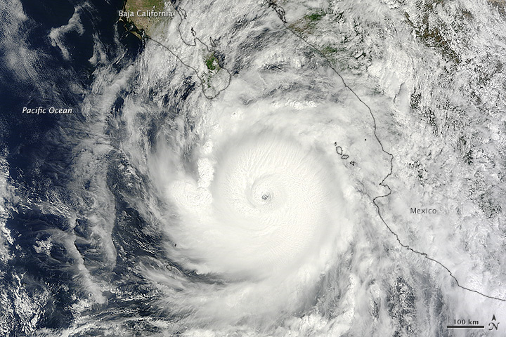
NASA image by Jeff Schmaltz, LANCE/EOSDIS Rapid Response. Caption by Kathryn Hansen.

At about 10:45 p.m. Mountain Daylight Time (MDT) on September 14, 2014, Hurricane Odile made landfall as a Category 3 storm near Cabo San Lucas, Mexico. According to the U.S. National Hurricane Center, Odile arrived with wind speeds of 110 knots (204 kilometers or 127 miles per hour). The storm tied Olivia (1967) as the strongest hurricane to make landfall in the state of Baja California Sur in the satellite era.

The Moderate Resolution Imaging Spectroradiometer (MODIS) on NASA’s Terra satellite acquired this natural-color view of the storm at about noon MDT on September 14, when it was still southeast of the Baja California peninsula. Unisys Weather reported that the Category 4 storm had maximum sustained wind speeds of 115 knots (213 kilometers per hour) at the time. Read more

Student winners of NASA’s 2014 educational “REEL Science Communication Contest” have completed their follow-on Earth science videos after a month-long workshop with NASA scientists and communication experts.

In May of 2014, NASA Earth science missions at NASA’s Goddard Space Flight Center in Greenbelt, Maryland, selected winners of their second annual video contest for high school students. The student winners each produced two-minute videos that communicate NASA Earth science to engage younger students. Winners were awarded the opportunity to work remotely with NASA experts to create new Earth science videos for NASA outreach.

Throughout July, contest winners Lena Korkeila from Placerville, California; Anna and Geof Olson from Santa Cruz, California; and Heather Forster, Sofia Bialkowski and Suzie Petryk from Huntington, New York, learned about NASA Earth science missions, communication efforts and video production.  Working with people from the Terra, Aqua and ICESat-2 Earth science missions and Goddard’s Office of Communications, the students pitched video ideas, wrote their scripts, identified NASA footage and visualizations, found or created accompanying music and recorded their narrations. Read more

china_tmo_2013357

NASA image courtesy Jeff Schmaltz, LANCE/EOSDIS MODIS Rapid Response Team at NASA GSFC. Caption by Adam Voiland.

The natural-color satellite image below offers both a modern and historical context. Captured by the Moderate Resolution Imaging Spectroradiometer (MODIS) on NASA’s Terra satellite, it shows heavy pollution heading toward Beijing, China, on December 12, 2013. If satellites had been flying in the first half of the 20th century, it’s reasonable to assume that skies over the eastern United States or Europe would have looked something like this on some days. Read more


namericalsta_tmo_2014215

If you live in the northern hemisphere, the past few weeks have been strange. In places where it should be seasonably hot—the eastern and southern United States and western Europe—it’s just been warm. In places where weather is usually mild in the summer—northern Europe, the Pacific coast of North America—it has been ridiculously hot. Read more

NASA Earth Observatory images by Jesse Allen, using data from the Land Processes Distributed Active Archive Center (LPDAAC). Caption by Michael Carlowicz, with image interpretation from Bill Patzert (NASA JPL), Jason Samenow (The Washington Post) and Linus Magnusson (European Centre for Medium-Range Weather Forecasting).

HurricaneIselle_tmo_2014216

In early August 2014, not one but two hurricanes were headed for the Hawaiian Islands. Storms arriving from the east are a relative rarity, and landfalling storms are also pretty infrequent.

The Moderate Resolution Imaging Spectroradiometer (MODIS) on NASA’s Terra satellite captured this natural-color image of Hurricane Iselle over the Pacific Ocean at 10:40 a.m. Hawaiian time (1940 Universal Time) on August 4, 2014. Shortly after the image was acquired, the U.S. Joint Typhoon Warning Center reported that Iselle was a category 4 hurricane with sustained winds at 120 knots (140 miles or 220 kilometers per hour) and centered at 16.10° north latitude, 137.40° west longitude. Read more

NASA image by Jeff Schmaltz, LANCE/EOSDIS Rapid Response. Caption by Mike Carlowicz.