Tag: Earth’s Surface and Interior

Earth’s Surface and Interior

caspiansea_amo_2016158

Does Dust Affect Water Levels of the Caspian Sea

June 10, 2016

Dust storms over the Caspian Sea lead to increased evaporation and a drop in lake level according to new research using observations of dust collected by instruments on several satellites including the Moderate Imaging Spectroradiometer (MODIS ) and the Multi-angle Imaging Spectroradiometer (MISR) on Terra.


ruapehu_ast_2016111

A Satellite Eye on Mount Ruapehu

June 5, 2010

Mount Ruapehu is one of New Zealand’s most active volcanoes and most visited, dotted with skiers and snowboarders along its slopes.  When it erupts lahars, flows of volcanic debris and sediment, can have devastating impacts, prompting geologists to regularly monitor the volcano, using the Advanced Spaceborne Thermal Emission and Reflection Radiometer on NASA’s Terra satellite.


April 26, 2016

A Sudden Color Change on Lake KivuThe Moderate Imaging Spectroradiometer (MODIS) on NASA’s Terra Satellite captured images of a whiting event in Lake Kivu. The seasonal event is stronger this year, giving Lake Kivu a milky color. 


April 22, 2016

Using Clouds to Map Life – A team of researchers are using cloud data from the Moderate Imaging Spectroradiometer (MODIS) on NASA’s Terra Satellite to create detailed maps of cloud cover and variability. The team found that cloud cover could be an indicator and a better predictor of a songbird and flower’s range than temperature and precipitation.


April 17, 2016

Yellowstone National Park – Learn about Yellowstone National Park and view an image made possible by the Digital Elevation Model from the Advanced Spaceborne Thermal Emission and Reflection Radiometer (ASTER) on NASA’s Terra satellite.


April 14, 2016

Sierra Nevada Snowpack is Better, But not Normal – Snowpack in the Sierra Nevada mountains dwindled over recent years; however, the winter of 2015-2016 and the strong El Nino provided a thicker and more extensive snowpack. Regardless, snow levels in the Sierra Nevada mountains were still below average. Images from NASA’s Moderate Imaging Spectroradiometer (MODIS) clearly show the difference between years.


April 13, 2016

Antarctic Ice Shelf Sheds Bergs – The Moderate Imaging Spectroradiometer on NASA’s Terra Satellite captured this striking image of the formation of two new icebergs as they broke away from the Nansen Ice Shelf into the Southern Ocean on April 7, 2016.


April 9, 2016

Greening Ascension Island – When Charles Darwin first visited Ascension Island it was barren, but with the assistance of Joseph Hooker in the 1800s plants were introduced and now cover much of this once bleak island. The image from the Advanced Spaceborne Thermal Emissions and Reflection Radiometer (ASTER) on NASA’s Terra satellite shows the now green Ascension Island and it’s Green Mountain.


April 3, 2016

Pavlov Erupts Again – Pavlov Volcano, Alaska’s most active volcano, began erupting for the first time since November 2014. The Moderate Resolution Imaging Spectroradiometer (MODIS) instruments on NASA’s Terra and Aqua satellites acquired images of the ash plume at 11:45 a.m on March 28, 2016.

Images of Wolf volcano on June 11, 2016. Image on left is from ASTER, showing Wolf Volcano in great detail. The image on the right is from MODIS. The red mark indicates a temperature anomaly or hot spot. Image Credit: Aster image from NASA Earth Observatory by Jesse Allen, using data from NASA/GSFC/METI/ERSDAC/JAROS, and U.S./Japan ASTER Science Team. MODIS image from NASA Worldview.

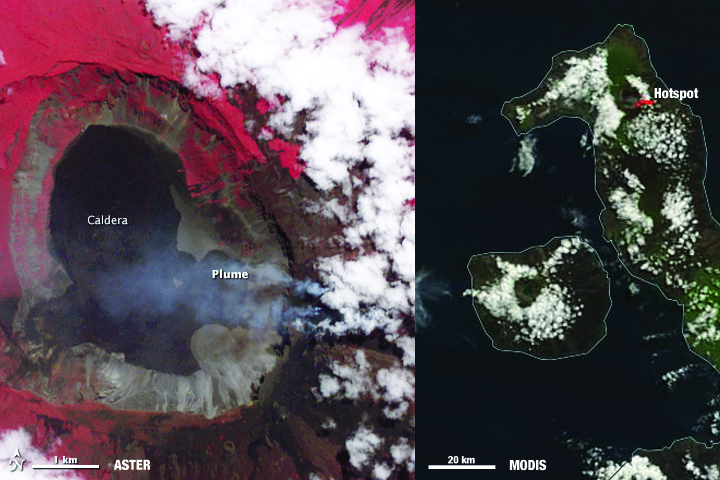
Images of Wolf volcano on June 11, 2015. ASTER image (left) shows Wolf Volcano in great detail. MODIS image (right) red marks indicate temperature anomalies or hot spots. Image Credit: Aster image from NASA Earth Observatory by Jesse Allen, using data from NASA/GSFC/METI/ERSDAC/JAROS, and U.S./Japan ASTER Science Team. MODIS image from NASA Worldview.

Not every volcano is as closely observed as Mount Saint Helens in Washington state or Mount Kilauea of Volcanoes National Park in Hawaii. These active volcanoes are closely monitored with specialized instruments dedicated to monitoring signs of volcanic activity. They are the exception, not the norm. Many volcanoes are remotely located and poorly monitored. However, NASA’s Terra satellite is helping identify potentially active volcanoes, better equipping surrounding communities to evacuate or take precautions before their local volcano erupts.

Two instruments on NASA’s Terra satellite, the Moderate Imaging Spectroradiometer (MODIS) and the Advanced Spaceborne Thermal Emissions and Reflection Radiometer (ASTER), along with instruments on other NASA and NOAA satellites are being used to identify and monitor potential areas of volcanic activity as part of the Urgent Request Protocol.

Not one satellite can do it all. “Monitoring of active volcanic processes using spaceborne data commonly requires different temporal, spatial and spectral scales depending on the science goal and process being observed,” according to Michael Ramsey from the University of Pittsburgh in his recent article, published on December 17, 2015.

Hotspots on Earth are identified by satellite images that have a thermal sensor, which measures the temperature, or infrared radiation, of Earth’s surface.MODIS, the Advanced Very High Resolution Radiometer (AVHRR) and ASTER all collect data on Earth’s temperature, but each of these sensors have different spatial resolutions. MODIS and AVHRR image large areas frequently, but lack detail. ASTER, on the other hand, has high spatial and spectral resolution, but lacks frequency.

AVHRR, MODIS and ASTER teamed up as part of the Urgent Request Protocol. AVHRR data was initially used exclusively until 2011, when MODIS data was integrated into the system. AVHRR and MODIS identify temperature changes on Earth’s surface that could indicate volcanic activity. These areas are flagged as being potentially active. When they are flagged, these locations are sent automatically to the Urgent Request Protocol database, where a request is submitted that ASTER look at these locations more closely on its next opportunity.

This allows stakeholders to potentially track detailed changes on that site every time ASTER passes. Prior to 2011, scientists manually reviewed flagged hotspots before being submitted to the Urgent Request Protocol for imaging by ASTER.

One benefit of using MODIS data over AVHRR is that it allows the system to be automated because MODIS data has less noise than AVHRR and has a higher detection threshold, reducing the number of false positives detected. Additionally, MODIS data is part of a global system where as the volcanic monitoring from AVHRR is isolated to the north Pacific region.

Beyond its global reach, the Urgent Request Protocol is one of the longest running programs focused on mission operations and volcanic science. Stakeholders and scientists anticipate the launch of the Hyperspectral Infrared Imager (HyspIRI), which will have a thermal infrared imager similar to ASTER on board. Information acquired by ASTER is used in the development of HyspIRI and future thermal infrared sensors, contributing to the extended satellite record and the next generation of Earth observing satellites tracking volcanic threats from space.

Watching from their vantage point outside of Earth, satellites will continue to witness volcanic eruptions and volcanic activity. While no one satellite can see the whole picture, when multiple satellites with the ability to measure Earth’s temperature frequently or in great detail are used together like in the Urgent Request Protocol, people benefit. The strong foundation laid by the Urgent Request Protocol will allow new data from the next fleet of satellites to continue to help people prepare for volcanic incidents.

momotombo_ast_2016062

Image Credit: NASA Earth Observatory image by Jesse Allen, using data from NASA/GSFC/METI/ERSDAC/JAROS, and U.S./Japan ASTER Science Team.

March 5, 2016
Eruption at Momotombo– The Advanced Spaceborne Thermal Emission and Reflection Radiometer on NASA’s Terra Satellite aquired this false color image of Momotombo volcano in Nicaragua erupting on March 2, 2016.


March 16, 2016
Flooding in the U.S. South– The Moderate Imaging Spectroradiometer on NASA’s Terra Satellite captured images of the flooding waters on the Mississippi River and White River in the southern United States.


March 18, 2016
Sand Mining at Poyang Lake– As part of an effort to assess the scale of the sand mining and its environmental impacts, a group of researchers analyzed data collected by the Advanced Spaceborne Thermal Emission and Reflection Radiometer (ASTER) sensor on NASA’s Terra satellite. Using infrared data collected by ASTER in 2005, the researchers found that the lake was producing up to 236 million cubic meters of sand per year—about 9 percent of the total produced by China. The researchers estimated that the volume of sand removed was probably enough to make Poyang Lake the largest sand mining operation in the world.


March 19, 2016
Northern California Floodway Fills– The Moderate Resolution Imaging Spectroradiometer (MODIS) on NASA’s Terra satellite captured  images of the river and floodway in northern California.  Storms in March 2016 brought water levels in this drought stricken region back to it’s historic average.

February 19, 2016
Ash Plume and Sea Ice Near Zhupanovsky – Since October, 2015 Zhupanovsky volcano in far eastern Russia has periodically been spewing ash into the atmosphere.  This MODIS image from February 13, 2016 shows an ash plume from Zhupanovsky volcano, which resulted in a code-red for air travel in the region.

Sea surface temperatures indicated that the warm "blob" has dissipated. NASA Earth Observatory image by Jesse Allen, using microwave and infrared multi-sensor SST data from Remote Sensing Systems.

February 12, 2016
The Demise of the Warm Blob – Ocean surface temperatures, showed a warm “blob” off the northern United State’s coast. This cell of warm ocean water in the Pacific Ocean no longer is present, having lasted from the winter of 2013 through December of 2015.

February 17, 2016
Waves Above and Below the Water – The Moderate Imaging Spectroradiometer on NASA’s Terra satellite acquired an image of wave patterns in the sky and in the water off the coast of Western Australia.

MODIS image of cloud streets over the Great Lakes.

February 11, 2016
Cloud Streets Over the Great Lakes – MODIS captured this image of cloud streets crossing the Great Lakes.

February 10, 2016
Snow in the Central U.S. – Snow from a blizzard blanketed parts of the Midwest. This image from Terra’s Moderate Imaging Spectroradiometer (MODIS) captured the snow that remained after the clouds cleared over Nebraska.

February 6, 2016
Open- and Closed-Celled Clouds over the Pacific – Terra’s Moderate Imaging Spectroradiometer (MODIS) captured in one image examples of two different types of convective clouds, open-celled and closed-celled.

February 5, 2016
Mount Erebus, Antarctica – Mount Erebus in Antarctica, thought to be the most southern volcano is still active. The Advanced Spaceborne Thermal Emissions and Reflection Radiometer (ASTER) on NASA’s Terra satellite captured images in visible and infrared, showing not just the volcano, but also the lava lake in its interior.

safricandvipa_tmo_201512

February 3, 2016
Drought in Southern Africa – Normalized Difference Vegetation Index (NDVI) data from Terra’s Moderate Imaging Spectroradiometer (MODIS) sensor are being used to track drought conditions in southern Africa, analyzing the effects of the current strong El Niño on vegetation.