Tag: CERES

CERES News and Events

100-remote-sensing-uses-logo-top

Image from GIS Geography. 100 Earth Shattering Uses and Applications of Remote Sensing.

GIS Geography published a list of 100 uses and applications of remote sensing, where data from NASA’s Terra satellite appeared in over 10%.

Listed below are some examples of Terra data uses that made the list (numbered by their original order in the article from GIS Geography):

13. Identifying forest stands and tallying their area to estimate forest supplies (MODIS)

26. Fighting wildfires by planning firefighter dispatch (MODIS)

27. Monitoring air quality in the lower atmosphere (MOPITT)

38. Keeping tabs on the shift from rural to urban growth (MODIS)

39. Quantifying crop conditions with Normalized Difference Vegetation Index (NDVI from MODIS)

59. Monitoring active volcanoes using thermal remote sensing (ASTER, MISR, and MODIS)

66. Looking at the Earth as an art masterpiece NASA’s Earth as Art | NASA Visible Earth

70. Comparing climatic factors from past to present (MODIS, CERES, MOPITT)

75. Studying geology of the Earth’s surface (ASTER, MISR, MODIS)

77. Measuring albedo for Earth’s radiation budget (CERES)

83. Delineating watersheds using DEMs for hydrologists (ASTER)

85. Using a least-cost analysis and vegetation to understand wildebeest migration (NDVI from MODIS)

Read the whole list and learn more about each of the uses and applications of remote sensing at 100 Earth Shattering Remote Sensing Applications Uses from GIS Geography

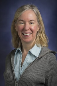
Portrait of Lin Chambers on blue background

Lin Hartung Chambers, a climate scientist and educator at NASA Langley Research Center in Hampton, Virginia, named a fellow of the American Association for the Advancement of Science. Credits: NASA Langley Research Center

Written by Chris Rink
NASA Langley Research Center, Hampton, VA

A climate scientist and educator at NASA’s Langley Research Center in Hampton, Virginia, has been named a fellow of the American Association for the Advancement of Science (AAAS), the world’s largest general scientific society.

The lead for education and communication at NASA Langley’s Science Directorate, Lin Hartung Chambers was among 347 members who were selected for their efforts to advance science or its applications in a scientifically or socially distinguished way.

As principal investigator for the MY NASA DATA project, Chambers makes NASA’s large collection of scientific data about the Earth more accessible to a wide audience, including both K-12 teachers and students, and the Citizen Science community. She is also the director of the Students’ Cloud Observations On-Line (S’COOL) Project, a program she created to use K-12 student data for validation of NASA’s Clouds and the Earth’s Radiant Energy System (CERES) satellite instrument cloud measurement products. Chambers was also a project scientist for the NASA Global Climate Change Education project working with a multi-agency community of climate change education funders and awardees.

The AAAS recognized Chambers for “For distinguished contributions to science education, particularly the coordination of students’ contributions to satellite data validation and improving the synergy of climate change education efforts.”

“It is a great honor to have my work recognized by my peers through AAAS,” Chambers said. “After nearly 19 years we continue to have enthusiastic participation from students ground-truthing satellite data, and we continue to evolve our activities to make their participation as rewarding as possible.”

Founded in 1848, AAAS is the publisher of the journal Science and includes 254 affiliated societies and academies of science serving 10 million people. The non-profit AAAS is open to all and fulfills its mission to “advance science and serve society” through initiatives in science policy, international programs, science education and more. The tradition of AAAS fellows began in 1874; members are considered for the rank of fellow if they are nominated and approved by their peers.

Chambers and the other new fellows will be presented with an official certificate and a gold and blue rosette pin representing science and engineering on Saturday, Feb. 13, from 8 a.m. to 10 a.m. at the AAAS Fellows Forum during the 2016 AAAS Annual Meeting in Washington, D.C. Chambers has a doctorate in aerospace engineering from North Carolina State University and received bachelor’s and master’s degrees in aeronautical engineering from Rensselaer Polytechnic Institute in Troy, New York. She has authored or co-authored more than 40 journal papers on science, engineering, and education and public outreach.

For more information about AAAS, visit:

www.aaas.org

For more information about NASA Langley, go to:

www.nasa.gov/langley

SciGirls (pbskids.org/scigirls), an Emmy award-winning PBS Kids television show featured NASA Langley atmospheric scientist, Yolanda Shea, in an episode where Virginia SciGirls Emma, Lauren and Madison use S’COOL (Student Cloud Observations Online) to identify clouds from the ground and compare their data with satellite images. S’COOL “involves participants from around the world in real science through making and reporting ground truth observations of clouds to assist NASA Scientists in the validation of NASA’s CERES satellite instruments,” according to the S’COOL website.   SciGirls and S’COOL teamed up to engage girls between the ages of 8- 12 in science, technology, engineering and math (STEM) careers and learning.  SciGirls has reached over 14 million girls, educators, and families, making it the most widely accessed girls’ STEM program available nationally.

Yolanda Shae, NASA Langley atmospheric scientist, helps SciGirls identify clouds in Virginia. Image credit: SciGirls.

The Advanced Spaceborne Thermal Emission and Reflection Radiometer (ASTER) is a 15-channel imaging instrument operating on NASA’s Terra satellite. A joint project between the U.S. National Aeronautics and Space Administration and Japan’s Ministry of Economy, Trade, and Industry, ASTER has been acquiring data for 15 years, since March 2000. The archive now contains over 2.8 million scenes; for the majority of them, a stereo pair was collected using nadir and backward telescopes imaging in the NIR wavelength.The majority of users require only a few to a few dozen scenes for their work. Studies have ranged over numerous scientific disciplines, and many practical applications have benefited from ASTER’s unique data. A few researchers have been able to mine the entire ASTER archive, that is now global in extent due to the long duration of the mission. Six examples of global products are described in this contribution:the ASTER Global Digital Elevation Model (GDEM), the most complete, highest resolution DEM available to all users; the ASTER Emissivity Database (ASTER GED), a global 5-band emissivity map of the land surface; the ASTER Global Urban Area Map (AGURAM), a 15-m resolution database of over 3500 cities;the ASTER Volcano Archive (AVA), an archive of over 1500 active volcanoes; ASTER Geoscience products of the continent of Australia; and the Global Ice Monitoring from Space (GLIMS) project.

Access the complete article on International Journal of Applied Earth Observation and Geoinformation

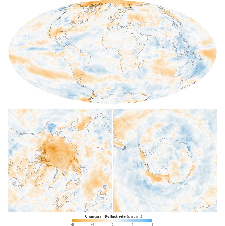
albedo_change

NASA Earth Observatory images by Robert Simmon based on data from CERES. Caption by Mike Carlowicz.

Sunlight is the primary driver of Earth’s climate and weather. Averaged over the entire planet, roughly 340 watts per square meter of energy from the Sun reach Earth. About one-third of that energy is reflected back into space, and the remaining 240 watts per square meter is absorbed by land, ocean, and atmosphere. Exactly how much sunlight is absorbed depends on the reflectivity of the atmosphere and the surface.

As scientists work to understand why global temperatures are rising and how carbon dioxide and other greenhouse gases are changing the climate system, they have been auditing Earth’s energy budget. Is more energy being absorbed by Earth than is being lost to space? If so, what happens to the excess energy?

For seventeen years, scientists have been examining this balance sheet with a series of space-based sensors known as Clouds and the Earth’s Radiant Energy System, or CERES. The instruments use scanning radiometers to measure both the shortwave solar energy reflected by the planet (albedo) and the longwave thermal energy emitted by it. Read more