Tag: CERES

CERES News and Events

Printed Wire Assemblies Back Online

To return function to 16 printed wire assemblies, including the two most recent, Terra’s Flight Operations Team rebooted Terra’s solid state recorder, on September 22, 2021. The successful reboot of Terra’s solid state recorder returned Terra to a level that allows full science acquisitions from all five instruments (ASTER, CERES, MISR, MODIS, and MOPITT). 

The recorder reboot took nearly 12 hours to complete. The board-by-board power up sequencing resulted in all 16 printed wire assemblies of the 16 offline assemblies returning to operational status.  Terra now has all 58 assemblies in service, and Terra’s data storage capacity is at the same level it had at launch. There are currently no known hardware limitations to the operation of Terra or any of its sensors and there is currently no official passivation (mission end) date. 

For over two decades Terra has collected valuable data about Earth’s systems. In February 2020 Terra stopped doing platform maneuvers that would control its equator crossing time in order to maintain fuel for collision avoidance maneuvers. The remaining fuel will also be used to lower Terra’s orbit as part of its eventual passivation process.  Now with the printed wire assemblies being returned to full function, Terra will be able to collect full data acquisitions from all five instruments throughout this process.

Terra will also continue collecting data after an orbit lowering maneuver planned for Fall 2022. The maneuver upholds agreements to ensure Terra is a safe distance from the other missions in the 705-km Earth Observing Satellite Constellation when fuel to maintain Terra’s orbit has been depleted.

“The science community views the changes in crossing time and orbit altitude as continuation of normal data collection for those products not affected by the orbital changes as well as an opportunity to do novel science with those that are affected,” according to Kurtis Thome, Terra Project Scientist.  The Terra Project fully expects the Terra platform and all five instruments to operate past 2026 allowing them to maintain their status as leaders in Earth science data production.  Terra’s long-term data record will continue to contribute to the Earth Science Division’s key science questions:

  • How is the global Earth system changing?
  • What causes these changes in the Earth system?
  • How will the Earth system change in the future?
  • How can Earth system science provide societal benefit?

Terra, the flagship Earth Observing Satellite, continues to be a leader in Earth science data, contributing to scientific research and applications worldwide, now with data capacity levels restored by a successful solid state recorder reboot.

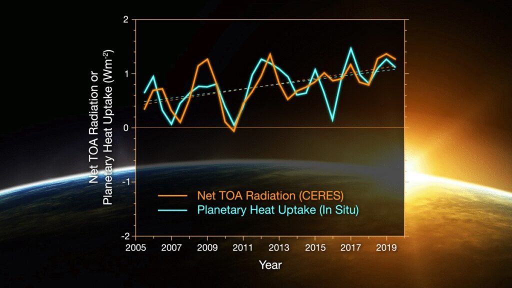
Comparison of overlapping one-year estimates at 6-month intervals of net top-of-the-atmosphere annual energy flux from CERES (solid orange line) and an in situ observational estimate of uptake of energy by Earth climate system (solid turquoise line).
Credits: NASA/Tim Marvel

Researchers have found that Earth’s energy imbalance approximately doubled during the 14-year period from 2005 to 2019.

Earth’s climate is determined by a delicate balance between how much of the Sun’s radiative energy is absorbed in the atmosphere and at the surface and how much thermal infrared radiation Earth emits to space. A positive energy imbalance means the Earth system is gaining energy, causing the planet to heat up. The doubling of the energy imbalance is the topic of a recent study, the results of which were published June 15 in Geophysical Research Letters.

Scientists at NASA and NOAA compared data from two independent measurements. NASA’s Clouds and the Earth’s Radiant Energy System (CERES) suite of satellite sensors measure how much energy enters and leaves Earth’s system. In addition, data from a global array of ocean floats, called Argo, enable an accurate estimate of the rate at which the world’s oceans are heating up. Since approximately 90 percent of the excess energy from an energy imbalance ends up in the ocean, the overall trends of incoming and outgoing radiation should broadly agree with changes in ocean heat content.

“The two very independent ways of looking at changes in Earth’s energy imbalance are in really, really good agreement, and they’re both showing this very large trend, which gives us a lot of confidence that what we’re seeing is a real phenomenon and not just an instrumental artifact, ” said Norman Loeb, lead author for the study and principal investigator for CERES at NASA’s Langley Research Center in Hampton, Virginia. “The trends we found were quite alarming in a sense.”

Increases in emissions of greenhouse gases such as carbon dioxide and methane due to human activity trap heat in the atmosphere, capturing outgoing radiation that would otherwise escape into space. The warming drives other changes, such as snow and ice melt, and increased water vapor and cloud changes that can further enhance the warming. Earth’s energy imbalance is the net effect of all these factors. In order to determine the primary factors driving the imbalance, the investigators used a method that looked at changes in clouds, water vapor, combined contributions from trace gases and the output of light from the Sun, surface albedo (the amount of light reflected by the Earth’s surface), tiny atmospheric particles called aerosols, and changes in surface and atmospheric temperature distributions.

The study finds that the doubling of the imbalance is partially the result an increase in greenhouse gases due to human activity, also known as anthropogenic forcing, along with increases in water vapor are trapping more outgoing longwave radiation, further contributing to Earth’s energy imbalance. Additionally, the related decrease in clouds and sea ice lead to more absorption of solar energy.

The researchers also found that a flip of the Pacific Decadal Oscillation (PDO) from a cool phase to a warm phase likely played a major role in the intensification of the energy imbalance. The PDO is a pattern of Pacific climate variability. Its fingerprint includes a massive wedge of water in the eastern Pacific that goes through cool and warm phases. This naturally occurring internal variability in the Earth system can have far-reaching effects on weather and climate. An intensely warm PDO phase that began around 2014 and continued until 2020 caused a widespread reduction in cloud coverage over the ocean and a corresponding increase in the absorption of solar radiation.

“It’s likely a mix of anthropogenic forcing and internal variability,” said Loeb. “And over this period they’re both causing warming, which leads to a fairly large change in Earth’s energy imbalance. The magnitude of the increase is unprecedented.”

Loeb cautions that the study is only a snapshot relative to long-term climate change, and that it’s not possible to predict with any certainty what the coming decades might look like for the balance of Earth’s energy budget. The study does conclude, however, that unless the rate of heat uptake subsides, greater changes in climate than are already occurring should be expected.

“The lengthening and highly complementary records from Argo and CERES have allowed us both to pin down Earth’s energy imbalance with increasing accuracy, and to study its variations and trends with increasing insight, as time goes on.” said Gregory Johnson, co-author on the study and physical oceanographer at the National Oceanic and Atmospheric Administration’s Pacific Marine Environmental Laboratory in Seattle, Washington. “Observing the magnitude and variations of this energy imbalance are vital to understanding Earth’s changing climate.”

Joe Atkinson
NASA’s Langley Research Center
Last Updated: Jun 16, 2021Editor: Joe Atkinson

Link to original article: https://www.nasa.gov/feature/langley/joint-nasa-noaa-study-finds-earths-energy-imbalance-has-doubled/

CERES will be hosting the 29th annual CERES Science Team Meeting jointly with GERB and ScaRaB from September 10 – 13 at NCAR in Boulder, Colorado. The meeting will showcase scientific findings and plans for the studying Earth’s radiation and energy from space.

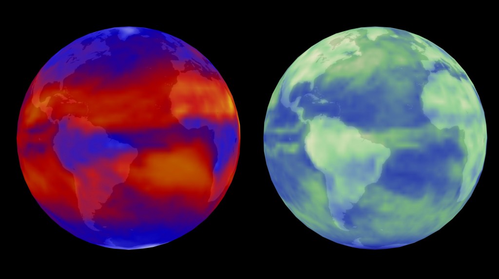
Terra/CERES views the world in outgoing longwave radiation (left) and reflected solar radiation (right). Image Credit: NASA

Terra/CERES views the world in outgoing longwave radiation (left) and reflected solar radiation (right). Image Credit: NASA

February 8, 2016

A study by scientists at NASA’s Jet Propulsion Laboratory in Pasadena, California, and Duke University in Durham, North Carolina, shows, in detail, the reason why global temperatures remain stable in the long run unless they are pushed by outside forces, such as increased greenhouse gases due to human impacts.

Lead author Patrick Brown, a doctoral student at Duke’s Nicholas School of the Environment, and his JPL colleagues combined global climate models with satellite measurements of changes in the energy approaching and leaving Earth at the top of the atmosphere over the past 15 years. The satellite data were from the Clouds and the Earth’s Radiant Energy System (CERES) instruments on NASA’s Aqua and Terra spacecraft. Their work reveals in new detail how Earth cools itself back down after a period of natural warming.

Scientists have long known that as Earth warms, it is able to restore its temperature equilibrium through a phenomenon known as the Planck Response. The phenomenon is an overall increase in infrared energy that Earth emits as it warms. The response acts as a safety valve of sorts, allowing more of the accumulating heat to be released through the top of Earth’s atmosphere into space.

The new research, however, shows it’s not quite as simple as that.

“Our analysis confirmed that the Planck Response plays the dominant role in restoring global temperature stability, but to our surprise, we found that it tends to be overwhelmed locally by heat-trapping changes in clouds, water vapor, and snow and ice,” Brown said. “This initially suggested that the climate system might be able to create large, sustained changes in temperature all by itself.”

A more detailed investigation of the satellite observations and climate models helped the researchers finally reconcile what was happening globally versus locally.

“While global temperature tends to be stable due to the Planck Response, there are other important, previously less appreciated, mechanisms at work, too,” said Wenhong Li, assistant professor of climate at Duke. These mechanisms include the net release of energy over anomalously cool regions and the transport of energy to continental and polar regions.  In those regions, the Planck Response overwhelms positive, heat-trapping local energy feedbacks.

“This emphasizes the importance of large-scale energy transport and atmospheric circulation changes in reconciling local versus global energy feedbacks and, in the absence of external drivers, restoring Earth’s global temperature equilibrium,” Li said.

The researchers say the findings may finally help put the chill on skeptics’ belief that long-term global warming occurs in an unpredictable manner, independently of external drivers such as human impacts.

“This study underscores that large, sustained changes in global temperature like those observed over the last century require drivers such as increased greenhouse gas concentrations,” said Brown.

“Scientists have long believed that increasing greenhouse gases played a major role in determining the warming trend of our planet,” added JPL co-author Jonathan Jiang. “This study provides further evidence that natural climate cycles alone are insufficient to explain the global warming observed over the last century.”

The research is published this month in the Journal of Climate. The study was funded by the National Science Foundation and NASA.

NASA uses the vantage point of space to increase our understanding of our home planet, improve lives and safeguard our future. NASA develops new ways to observe and study Earth’s interconnected natural systems with long-term data records. The agency freely shares this unique knowledge and works with institutions around the world to gain new insights into how our planet is changing.

For more information about NASA’s Earth science activities, visit:

http://www.nasa.gov/earth

Alan Buis
Jet Propulsion Laboratory, Pasadena, Calif.
818-354-0474
Alan.buis@jpl.nasa.gov

Tim Lucas
Duke University, Durham, North Carolina
919-613-8084
tdlucas@duke.edu

2016-036

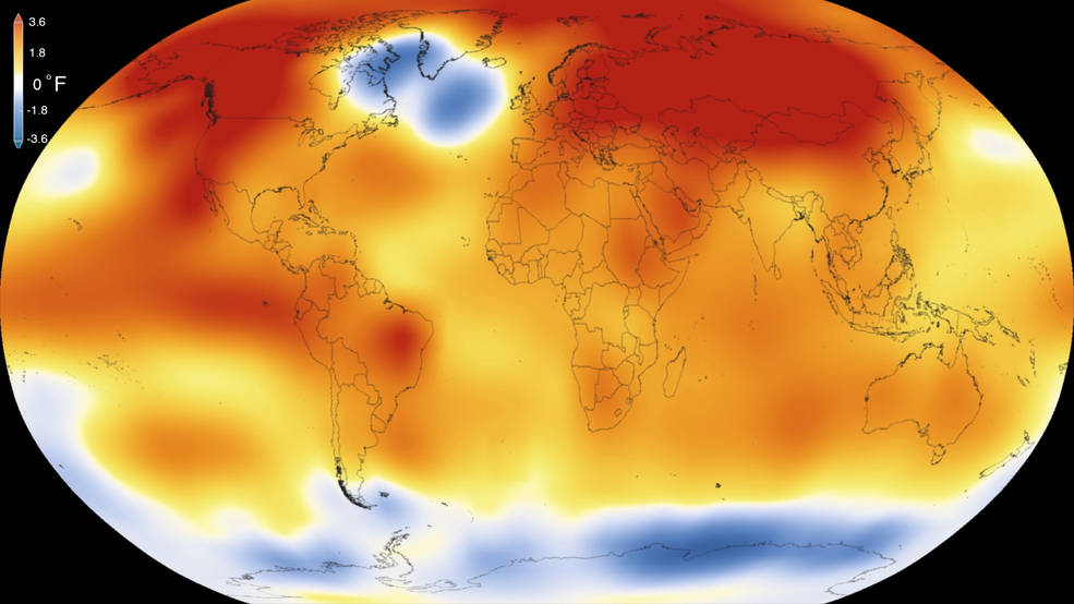
Global temperature anomolies

2015 was the warmest year since modern record-keeping began in 1880, according to a new analysis by NASA’s Goddard Institute for Space Studies. The record-breaking year continues a long-term warming trend — 15 of the 16 warmest years on record have now occurred since 2001. Credits: Scientific Visualization Studio/Goddard Space Flight Center

2015 was the hottest year ever recorded*, but what does Terra have to do with it?

On January 20th, 2016, scientists from NASA’s Goddard Institute for Space Studies (GISS) and National Oceanic and Atmospheric Administration (NOAA) released their analysis based on data gathered on Earth’s surface temperatures. There are two primary sources of data, ground measurements and satellite. While GISS and NOAA studies relied on surface-based measurements, data from satellite instruments, such as those on-board NASA’s Terra satellite are critical for better understanding of global temperatures as a function of time.

“The length and quality of the Terra data record makes it well suited as a check of the global temperature results and can help guide choices on ways to process the surface data,” according the Kurt Thome, Terra project scientist. Three of the Terra sensors have data that are well suited to serve as a validation source, allowing the researchers and scientists to go back and check their data. If surface and satellite measurements are the same, then the scientists responsible for creating the data products can conclude that the product is accurate. This increases confidence in the satellite data’s accuracy as well as verifying that the ground measurements are also accurate. When accurate data is put into the climate models the accuracy of the models is increased.

The Moderate Imaging Spectroradiometer (MODIS) measures Land Surface Temperatures (LST) and Sea Surface Temperatures (SST). There are two MODIS instruments in orbit, one on Terra and the other on Aqua. While the data analyzed in the NASA/NOAA report relies primarily on data from ground stations, the data gathered by MODIS can help “fill in the blanks” of areas where there are not many ground observations available. The data from MODIS, not only can be used to verify that ground instruments are working correctly, but it can also be used to add values to the climate models, that may otherwise be left blank.

The Advanced Spaceborne Thermal Emission and Reflection Radiometer (ASTER) also on NASA’s Terra Satellite, can sense temperature emissions, but at a higher resolution than MODIS.   In fact, ASTER is responsible for the highest resolution global emissivity database. While emissivity isn’t the same as land surface temperature the two are linked because how well a material emits combined with its temperature determines how much energy is given off. When temperatures rise, areas that were once vegetated can become arid causing a change in the emissivity and further changing how energy is distributed between vegetated and arid regions. ASTER, with its narrow swath and high resolution, required several years to create its global emissivity product. Combining the ASTER results with the daily MODIS measurements allows MODIS scientists to retrieve daily LST.

Finally, Clouds and the Earth’s Radiant Energy System (CERES) measures both emitted energy from the earth and solar-reflected energy. Combining these data with the amount of incident solar energy allows CERES scientists to do a full accounting of the Earth’s energy budget. Less reflected energy and greater emitted energy implies a warming planet. CERES, through measuring the amount of energy in the form of heat that is coming from Earth, can be used to validate ground measurements from weather stations. Conversely the ground stations can validate the measurements taken by CERES. Like MODIS and ASTER, this helps increase confidence in the current climate models.

While satellite monitoring of the Earth is relatively new compared the hundreds of years of historic records, satellite data is increasingly being used to help validate the most recent additions to the historic record. Satellite data allows scientists to get global coverage and increase confidence in the data that feeds climate models. Even though Earth is warming, satellite data are better equipped to model the increased temperatures and help citizens and policymakers understand the implications.


Read the press release from NASA GISS and NOAA

Read more on NASA’s Earth Observatory

*modern record keeping began in 1880.