Tag: CERES

CERES News and Events

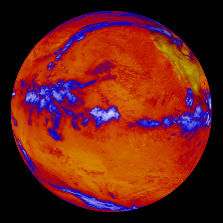
CERES data over Pacific Ocean

While the upper part of the world’s oceans continue to absorb heat from global warming, ocean depths have not warmed measurably in the last decade. This image shows heat radiating from the Pacific Ocean as imaged by the NASA’s Clouds and the Earth’s Radiant Energy System instrument on the Terra satellite. (Blue regions indicate thick cloud cover.)

The cold waters of Earth’s deep ocean have not warmed measurably since 2005, according to a new NASA study, leaving unsolved the mystery of why global warming appears to have slowed in recent years.

Scientists at NASA’s Jet Propulsion Laboratory (JPL) in Pasadena, California, analyzed satellite and direct ocean temperature data from 2005 to 2013 and found the ocean abyss below 1.24 miles (1,995 meters) has not warmed measurably. Study coauthor Josh Willis of JPL said these findings do not throw suspicion on climate change itself.

“The sea level is still rising,” Willis noted. “We’re just trying to understand the nitty-gritty details.”

In the 21st century, greenhouse gases have continued to accumulate in the atmosphere, just as they did in the 20th century, but global average surface air temperatures have stopped rising in tandem with the gases. The temperature of the top half of the world’s oceans — above the 1.24-mile mark — is still climbing, but not fast enough to account for the stalled air temperatures.

Many processes on land, air and sea have been invoked to explain what is happening to the “missing” heat. One of the most prominent ideas is that the bottom half of the ocean is taking up the slack, but supporting evidence is slim. This latest study is the first to test the idea using satellite observations, as well as direct temperature measurements of the upper ocean. Scientists have been taking the temperature of the top half of the ocean directly since 2005, using a network of 3,000 floating temperature probes called the Argo array.

“The deep parts of the ocean are harder to measure,” said JPL’s William Llovel, lead author of the study published Sunday in the journal Nature Climate Change. “The combination of satellite and direct temperature data gives us a glimpse of how much sea level rise is due to deep warming. The answer is — not much.”

The study took advantage of the fact that water expands as it gets warmer. The sea level is rising because of this expansion and the water added by glacier and ice sheet melt.

To arrive at their conclusion, the JPL scientists did a straightforward subtraction calculation, using data for 2005-2013 from the Argo buoys, NASA’s Jason-1 and Jason-2 satellites, and the agency’s Gravity Recovery and Climate Experiment (GRACE) satellites. From the total amount of sea level rise, they subtracted the amount of rise from the expansion in the upper ocean, and the amount of rise that came from added meltwater. The remainder represented the amount of sea level rise caused by warming in the deep ocean.

The remainder was essentially zero. Deep ocean warming contributed virtually nothing to sea level rise during this period.

Coauthor Felix Landerer of JPL noted that during the same period warming in the top half of the ocean continued unabated, an unequivocal sign that our planet is heating up. Some recent studies reporting deep-ocean warming were, in fact, referring to the warming in the upper half of the ocean but below the topmost layer, which ends about 0.4 mile (700 meters) down.

Landerer also is a coauthor of another paper in the same journal issue on 1970-2005 ocean warming in the Southern Hemisphere. Before Argo floats were deployed, temperature measurements in the Southern Ocean were spotty, at best. Using satellite measurements and climate simulations of sea level changes around the world, the new study found the global ocean absorbed far more heat in those 35 years than previously thought — a whopping 24 to 58 percent more than early estimates.

Both papers result from the work of the newly formed NASA Sea Level Change Team, an interdisciplinary group tasked with using NASA satellite data to improve the accuracy and scale of current and future estimates of sea level change. The Southern Hemisphere paper was led by three scientists at Lawrence Livermore National Laboratory in Livermore, California.

NASA monitors Earth’s vital signs from land, air and space with a fleet of satellites and ambitious airborne and ground-based observation campaigns. NASA develops new ways to observe and study Earth’s interconnected natural systems with long-term data records and computer analysis tools to better see how our planet is changing. The agency shares this unique knowledge with the global community and works with institutions in the United States and around the world that contribute to understanding and protecting our home planet.

For more information about NASA’s Earth science activities in 2014, visit:

http://www.nasa.gov/earthrightnow

For more information on ocean surface topography from space, visit:

http://sealevel.jpl.nasa.gov

More information on NASA’s GRACE satellites is available at:

http://grace.jpl.nasa.gov

For more information on the Argo array, visit:

http://www.argo.ucsd.edu/index.html

Student winners of NASA’s 2014 educational “REEL Science Communication Contest” have completed their follow-on Earth science videos after a month-long workshop with NASA scientists and communication experts.

In May of 2014, NASA Earth science missions at NASA’s Goddard Space Flight Center in Greenbelt, Maryland, selected winners of their second annual video contest for high school students. The student winners each produced two-minute videos that communicate NASA Earth science to engage younger students. Winners were awarded the opportunity to work remotely with NASA experts to create new Earth science videos for NASA outreach.

Throughout July, contest winners Lena Korkeila from Placerville, California; Anna and Geof Olson from Santa Cruz, California; and Heather Forster, Sofia Bialkowski and Suzie Petryk from Huntington, New York, learned about NASA Earth science missions, communication efforts and video production.  Working with people from the Terra, Aqua and ICESat-2 Earth science missions and Goddard’s Office of Communications, the students pitched video ideas, wrote their scripts, identified NASA footage and visualizations, found or created accompanying music and recorded their narrations. Read more

Terra is now well into her teenage years, but is by no means setting records for the longest operating satellite.  In fact, Terra has only been collecting data half as long as Landsat 5, which set the record for longest operating satellite last year after operating for 28 years and 10 months.  Terra has surpassed its intended design life by 8 years, but it is still collecting meaningful data, giving scientists insight into how different systems on Earth effect each other.

Beyond Terra’s contributions to scientific research, it continues to help monitor forest fires, equipping land managing agencies with the ability to track a fire’s progress and identify areas of concern.  Terra also continues to witness phytoplankton blooms, monitor changes in ice shelves, witness volcanic eruptions, and track dust, haze and smog as it travels from its source. Terra is improving climate and weather models, helping forecasters make better predictions.

In addition to Terra’s scientific and climate contributions, it continues to showcase how the United States in partnership with other countries, like Japan and Canada, can work together to increase knowledge and gain a better understanding of Earth’s varying climate and the interconnectedness of Earth’s systems. Since Terra’s launch, other satellites such as the Global Precipitation Measurement (GPM), expected to launch in 2014, have followed Terra’s lead by partnering with other countries to provide scientist’s with a wide array of information to better understand Earth.


Much has changed since Magellan circumnavigated Earth almost 500 years ago or since the first astronaut orbited Earth over 50 years ago. August 26, 2013 marks another historical event in exploring our earth. Terra, the flagship Earth Observing Satellite, sees the Earth for the 5,000th day celebrating its 5,000th day on orbit.

Terra paved the way for other Earth Observing Satellites through observations made by its five instruments from three countries, MODIS, MISR, and CERES from the United States, ASTER from Japan, and MOPITT from Canada.  Terra is a global partnership, advancing the scientific understanding of our Earth’s processes and changing climate.

MODIS, the MODerate Imaging Spectroradiometer, has captured images of numerous wildfires, hurricanes, and other natural events, while quantifying the amount of vegetation that covers Earth, monitoring sea surface temperature, capturing ocean color, observing the lower atmosphere and providing traceable images of the changing ice sheets. Since its launch in December of 1999 Terra MODIS has supplied irreplaceable data to monitor climate change, improving understanding of global dynamics and processes occurring on Earth.

MISR, the Multi-angle Imaging SpectroRadiometer, monitors Earth from multiple angles at the same time. MISR, the first instrument of its kind, measures the amount of sunlight that is scattered in different directions from Earth’s surface and atmosphere through its suite of nine pushbroom sensors pointed in different directions.  MISR gives depth to what would otherwise be flat images, revealing what lies below the initial surface as seen from space. MISR also distinguishes different types of clouds, particles and surfaces, monitoring trends and contributing to the historical record of a changing climate.

CERES, Clouds and Earth’s Radiant Energy System, on Terra was the second to launch.  The most recent CERES instrument launched in 2011 onboard the Suomi National Polar-orbiting Partnership (NPP) Satellite.  CERES data leads to a better understanding of the role of clouds and the energy cycle in global climate change through taking measurements of incoming and outgoing solar radiation related to cloud properties and physics, enhancing the accuracy of current climate models.

ASTER, Advanced Spaceborne Thermal Emission and Reflection Radiometer, data is used to create detailed maps of land surface temperature, reflectance, and elevation. It is a cooperative effort between NASA, Japan’s Ministry of Economy, Trade and Industry (METI), and Japan Space Systems. Anytime a volcano erupts, ASTER is able to see the thermal fingerprint left by the cascading lava and the warm surface temperature.  ASTER measures infrared radiation and contributes to data sets that reveal more than meets the eye about land use, hydrology, and geologic composition of the land. Its data are used to locate archeologically significant areas, to assist in locating mineral deposits and mapping geologic features, as well as to further the understanding of how humans and natural events change Earth’s surface.  ASTER’s high resolution makes it possible to monitor Earth’s surface at a higher resolution than Terra’s other instruments, enhancing validation and calibration capabilities.

MOPITT, Measurements Of Pollution in The Troposphere, measure tropospheric carbon monoxide (CO) on a global scale. Methane oxidation, fossil fuel consumption and biomass burning produce CO. MOPITT data enables scientists to analyze sources and sinks of CO and track CO’s movement throughout the globe. Through studying this trace gas scientists are able to map CO levels in the lower atmosphere, furthering our understanding of how CO levels change due to both natural and human caused events, ultimately helping understand pollution’s role in climate change.

5,000 days orbiting the Earth is enough to make anyone’s head spin, but Terra has done little to make people dizzy.  Instead, this forerunner in collecting climate science data has paved the way for other satellite missions to clearly understand what changes are occurring on Earth and how they may continue to change well into the future.  As Terra continues into its teenage years, mature for a satellite, it continues to collect measurements that lead to a better understanding of our changing planet.


Resources:

http://www-misr.jpl.nasa.gov

http://asterweb.jpl.nasa.gov

http://ceres.larc.nasa.gov

http://www2.acd.ucar.edu/mopitt

http://modis.gsfc.nasa.gov/


article by Tassia Owen

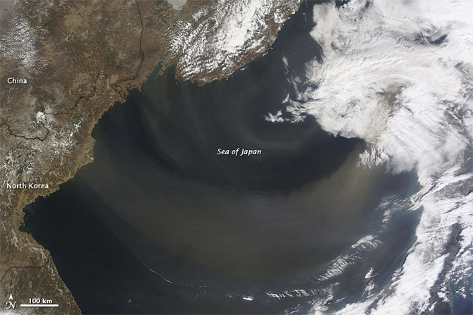
Dust Moving West of Sea of Japan

NASA and university scientists have made the first measurement-based estimate of the amount and composition of tiny airborne particles that arrive in the air over North America each year. With a 3-D view of the atmosphere now possible from satellites, the scientists calculated that dust, not pollution, is the main ingredient of these imports.Read more.