The 2014 MODIS Science Team Meeting will take place at the Sheraton Columbia Town Center Hotel in Columbia, MD from April 29th through May 1. Please see the agenda for times of sessions and a list of speakers.


The EOS Flagship
Past News
- December 2025
- October 2025
- July 2025
- May 2025
- February 2025
- November 2024
- April 2024
- February 2024
- December 2023
- October 2023
- April 2023
- February 2023
- December 2022
- October 2022
- August 2022
- July 2022
- June 2022
- April 2022
- March 2022
- October 2021
- September 2021
- August 2021
- June 2021
- May 2021
- April 2021
- March 2021
- February 2021
- January 2021
- September 2020
- August 2020
- July 2020
- April 2020
- February 2020
- January 2020
- December 2019
- November 2019
- October 2019
- September 2019
- August 2019
- April 2019
- March 2019
- November 2018
- October 2018
- August 2018
- July 2018
- June 2018
- May 2018
- November 2017
- June 2017
- August 2016
- July 2016
- June 2016
- May 2016
- April 2016
- March 2016
- February 2016
- January 2016
- December 2015
- November 2015
- October 2015
- September 2015
- August 2015
- April 2015
- February 2015
- December 2014
- November 2014
- October 2014
- September 2014
- August 2014
- May 2014
- April 2014
- March 2014
- February 2014
- January 2014
- December 2013
- November 2013
- October 2013
- September 2013
- August 2013
- July 2013
- June 2013
- May 2013
- April 2013
- March 2013
- February 2013
- January 2013
- September 2012
- June 2012
- May 2012
- April 2012
- March 2012
- February 2012
- January 2012
News By Instrument
News By Science
- Air quality
- Applications
- Atmosphere
- Carbon Cycle and Ecosystems
- Climate Variability and Change
- Data
- Earth Observatory
- Earth's Surface and Interior
- Education
- Energy Cycle
- Events
- Human Dimensions
- LAADS DAAC
- Landsat
- Orbital Changes
- Platform
- Resources
- Terra Talent Series
- Terra Visits Camp Landsat
- VIIRS
- Water Cycle
- Weather
- Wildfire
Year: 2014
Ship Wave Clouds Behind the Crozet Islands
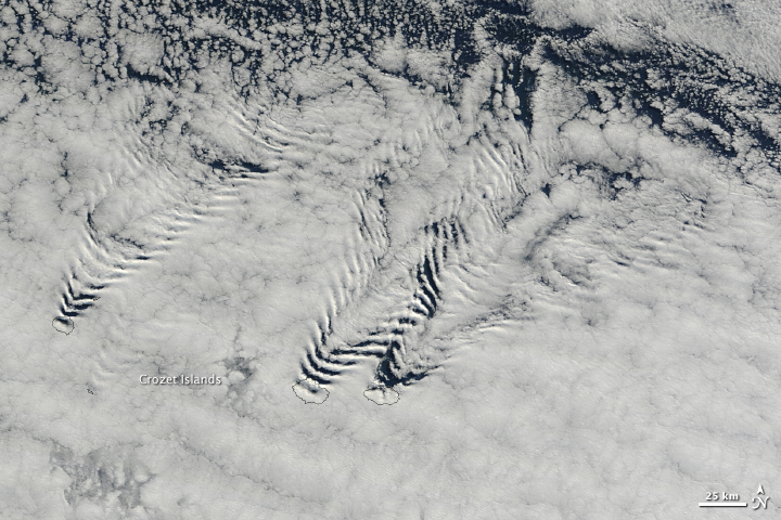
Air flows like water in the atmosphere with invisible currents and waves. On April 9, 2014, the Moderate Resolution Imaging Spectroradiometer (MODIS) on NASA’s Terra satellite captured this view that evokes fluid-like movement in the atmosphere. Ship wave clouds fan out behind the Crozet Islands over the southern Indian Ocean looking exactly like the ripples behind a rock in a stream or the waves behind a boat moving through calm water. Read more
- NASA image courtesy Jeff Schmaltz, LANCE/EOSDIS MODIS Rapid Response Team at NASA GSFC. Caption by Holli Riebeek.
Painting with Islands and Sunglint
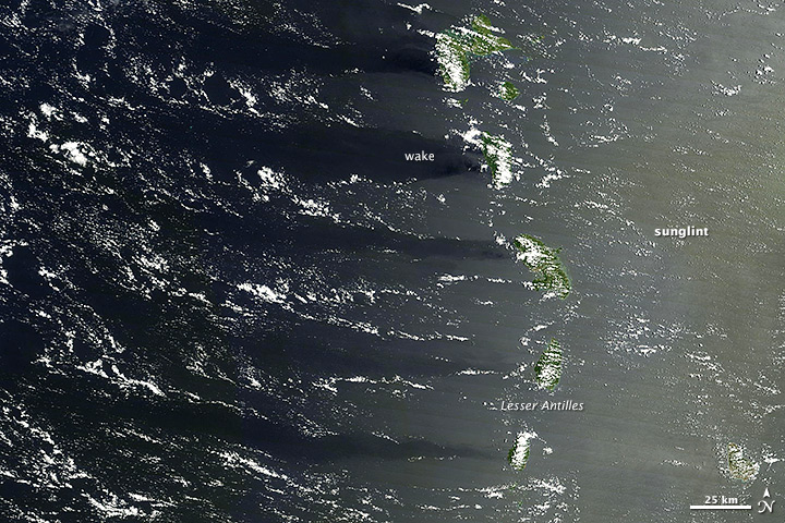
The satellites in NASA’s Earth Observing System collect data and imagery for scientific research. The data goes to one of twelve Distributed Active Archive Centers (DAACs) across the United States, where it is processed and distributed to scientists who mine it for clues about our environment.
But sometimes the imagery is remarkable simply for its beauty. When the Moderate Resolution Imaging Spectroradiometer (MODIS) on NASA’s Terra satellite looked down on the Lesser Antilles on August 1, 2013, the combination of sunlight, islands, and wind painted this scene on the surface of the Caribbean Sea. The right side of the image has a milky hue because of sunglint, an optical effect caused by the mirror-like reflection of sunlight off the water surface directly back at the satellite sensor. Read more
- NASA image courtesy LANCE/EOSDIS MODIS Rapid Response Team, GSFC. Caption by Adam Voiland and Michael Carlowicz.
Drifting with Ice Island B31
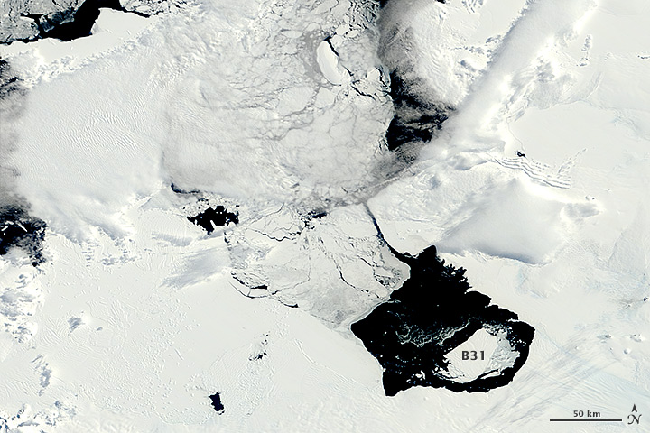
In early November 2013, a large iceberg separated from the front of Antarctica’s Pine Island Glacier. It thus began a journey across Pine Island Bay, a basin of the Amundsen Sea. The ice island, named B31, will likely be swept up soon in the swift currents of the Southern Ocean, though it will be hard to track visually for the next six months as Antarctica heads into winter darkness.
Over the course of five months in Antarctic spring and summer, the Moderate Resolution Imaging Spectroradiometer (MODIS)—an instrument on NASA’s Terra and Aqua satellites—captured a series of images of ice island B31. Read more
- NASA images by Jeff Schmaltz, LANCE/EOSDIS Rapid Response. Caption by Michael Carlowicz.
Mapping Minerals with Light
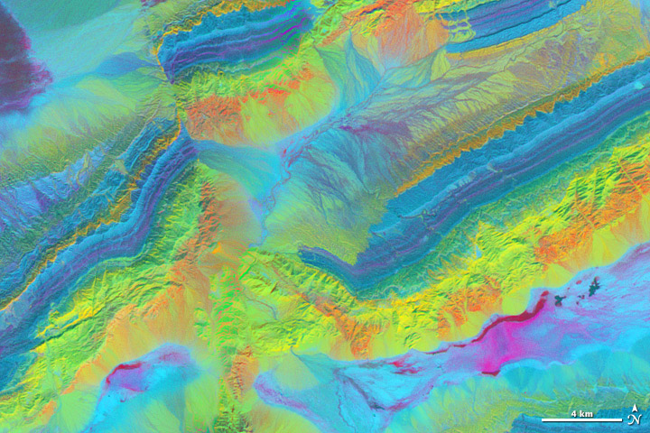
A satellite image is more than a photo. It is a picture of the amount and type of energy reflected or emitted by the Earth and recorded by a satellite instrument. There are many ways to combine those measurements to create an image, and each combination provides different insights.
The spectacular exposed geology of northwestern China offers an ideal landscape for illustrating how satellite measurements can identify minerals from afar. In satellite imagery, this area has three different sedimentary rock layers that are visible as rainbow stripes on a series of ridges. The Piqiang Fault has split the ridgeline, so the colored layers are offset by about three kilometers (two miles). All of the images on this page were made from data acquired on February 24, 2005, by the Advanced Spaceborne Thermal Emission and Reflection Radiometer (ASTER) on NASA’s Terra satellite. Read more
- NASA image by Robert Simmon with ASTER data. Caption by Holli Riebeek with information and review provided by David Mayer, Robert Simmon, and Michael Abrams.