Tag: Weather

Weather News and Events

GreatLakes_tmo_2014269

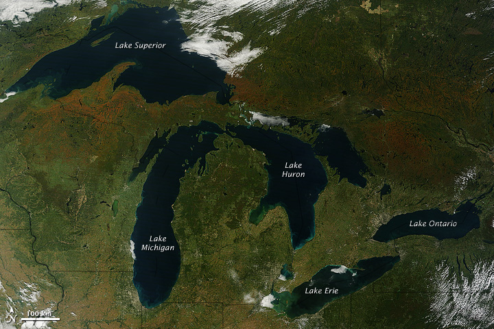
NASA image courtesy Jeff Schmaltz, LANCE MODIS Rapid Response Team at NASA GSFC. Caption by Mike Carlowicz.

A few days after autumn showed up on the calendar in the Northern Hemisphere, it showed up on the landscape of North America. The Moderate Resolution Imaging Spectroradiometer (MODIS) on NASA’s Terra satellite captured these views of fall colors around the Great Lakes (September 26) and New England (September 27, 2014). The brown and orange shades are most pronounced in the Upper Peninsula of Michigan, northern Wisconsin, upstate New York, New Hampshire, Vermont, Maine, and southern Quebec and Ontario. You can also see faint traces of phytoplankton blooms in the lakes and offshore in the North Atlantic.

The changing of leaf color in temperate forests involves several causes and reactions, but the dominant factors are sunlight and heat. Since temperatures tend to drop sooner and sunlight fades faster at higher latitudes, the progression of fall color changes tends to move from north to south across North America from mid-September through mid-November. Read more

See an animation of the changing colors on this article from the Huffington Post.

odile_tmo_2014257

NASA image by Jeff Schmaltz, LANCE/EOSDIS Rapid Response. Caption by Kathryn Hansen.

At about 10:45 p.m. Mountain Daylight Time (MDT) on September 14, 2014, Hurricane Odile made landfall as a Category 3 storm near Cabo San Lucas, Mexico. According to the U.S. National Hurricane Center, Odile arrived with wind speeds of 110 knots (204 kilometers or 127 miles per hour). The storm tied Olivia (1967) as the strongest hurricane to make landfall in the state of Baja California Sur in the satellite era.

The Moderate Resolution Imaging Spectroradiometer (MODIS) on NASA’s Terra satellite acquired this natural-color view of the storm at about noon MDT on September 14, when it was still southeast of the Baja California peninsula. Unisys Weather reported that the Category 4 storm had maximum sustained wind speeds of 115 knots (213 kilometers per hour) at the time. Read more

HurricaneIselle_tmo_2014216

In early August 2014, not one but two hurricanes were headed for the Hawaiian Islands. Storms arriving from the east are a relative rarity, and landfalling storms are also pretty infrequent.

The Moderate Resolution Imaging Spectroradiometer (MODIS) on NASA’s Terra satellite captured this natural-color image of Hurricane Iselle over the Pacific Ocean at 10:40 a.m. Hawaiian time (1940 Universal Time) on August 4, 2014. Shortly after the image was acquired, the U.S. Joint Typhoon Warning Center reported that Iselle was a category 4 hurricane with sustained winds at 120 knots (140 miles or 220 kilometers per hour) and centered at 16.10° north latitude, 137.40° west longitude. Read more

NASA image by Jeff Schmaltz, LANCE/EOSDIS Rapid Response. Caption by Mike Carlowicz.

neoguri_tmo_2014190

Typhoon Neoguri pounded Okinawa and other Western Pacific islands with torrential rain and damaging winds in mid-July 2014, en route to a likely landfall in Japan. The Visible Infrared Imaging Radiometer Suite (VIIRS) on the Suomi NPP satellite captured a nighttime image of the storm at 2:07 a.m. Japan Standard Time on July 9, 2014 (17:07 Universal Time on July 8). At the time, Neoguri was a category 2 typhoon moving through the East China Sea.

The storm was imaged by a special “day-night band” that detects light in a range of wavelengths from green to near-infrared and uses light intensification to detect dim signals. The instrument can sense light as much as 100,000 times fainter than conventional visible-light sensors, making it very sensitive to moonlight and city lights. In this case, the cloud tops were lit by the nearly full Moon.

The Moderate Resolution Imaging Spectroradiometer (MODIS) on NASA’s Terra satellite captured a natural-color image of Neoguri at 11:30 a.m. local time (0230 Universal Time) on July 9, 2014. Read more

Terra MODIS image by Jeff Schmaltz, LANCE/EOSDIS Rapid Response. Caption by Michael Carlowicz.

pilger_ast_2014172

On June 16, 2014, a tornadic thunderstorm system moved across portions of northeast Nebraska, producing 5 tornadoes. Four of the tornadoes were rated as EF-4 on the Enhanced Fujita Scale, meaning that they were violent tornadoes with winds between 166 and 200 miles per hour. One EF-4 tornado spun directly through Pilger, Nebraska, a small town of 350 people, leveling much of the town.

The Advanced Spaceborne Thermal Emission and Reflection Radiometer (ASTER) instrument aboard NASA’s Terra satellite captured the top image of northeast Nebraska on June 21, 2014. Two of the EF-4 tornado tracks are visible in the false-color image (near-infrared, red, green). The tracks are tan paths of bare ground across plant-covered fields, which are red. The towns of Pilger and Wisner are bright white. The lower image, also from the ASTER instrument, shows the region on July 4, 2013. Turn on the comparison tool to contrast the before and after views. Read more

NASA Earth Observatory image by Jesse Allen, using data from NASA/GSFC/METI/ERSDAC/JAROS, and U.S./Japan ASTER Science Team. Caption by Kari Beckendorf and Holli Riebeek.