Tag: ASTER

ASTER News and Events

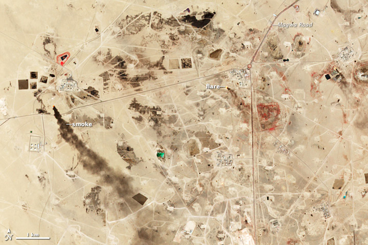
NASA Earth Observatory image by Jesse Allen and Robert Simmon, using data from NASA/GSFC/METI/ERSDAC/JAROS, and U.S./Japan ASTER Science Team. Caption by Adam Voiland.

Though a small nation, Kuwait has an outsized role in oil production. The country has an estimated 94 billion barrels of proven oil reserves, about 9 percent of the world’s total. The oldest and largest of Kuwait’s oil fields-the Greater Burgan field in southeastern Kuwait-produces about 1.6 million barrels of oil a day.

The Greater Burgan is comprised of three smaller fields: Burgan, Magwa, and Ahmadi. The first oil well was installed in Burgan in 1938. Oil was discovered at the Magwa field in 1950 and at the Ahmadi field in 1952. The Advanced Spaceborne Thermal Emission and Reflection Radiometer (ASTER) on NASA’s Terra satellite captured this image of a portion of the Burgan field on September 27, 2009. Read more

NASA Earth Observatory image by Jesse Allen and Robert Simmon, using data from NASA/GSFC/METI/ERSDAC/JAROS, and U.S./Japan ASTER Science Team. Caption by Adam Voiland.
Terra is now well into her teenage years, but is by no means setting records for the longest operating satellite.  In fact, Terra has only been collecting data half as long as Landsat 5, which set the record for longest operating satellite last year after operating for 28 years and 10 months.  Terra has surpassed its intended design life by 8 years, but it is still collecting meaningful data, giving scientists insight into how different systems on Earth effect each other.

Beyond Terra’s contributions to scientific research, it continues to help monitor forest fires, equipping land managing agencies with the ability to track a fire’s progress and identify areas of concern.  Terra also continues to witness phytoplankton blooms, monitor changes in ice shelves, witness volcanic eruptions, and track dust, haze and smog as it travels from its source. Terra is improving climate and weather models, helping forecasters make better predictions.

In addition to Terra’s scientific and climate contributions, it continues to showcase how the United States in partnership with other countries, like Japan and Canada, can work together to increase knowledge and gain a better understanding of Earth’s varying climate and the interconnectedness of Earth’s systems. Since Terra’s launch, other satellites such as the Global Precipitation Measurement (GPM), expected to launch in 2014, have followed Terra’s lead by partnering with other countries to provide scientist’s with a wide array of information to better understand Earth.


Terra and her instruments made an appearance in many of the presentations at the American Geophysical Union’s 46th annual Fall Meeting held December 9th – 13th. Scientists, researchers, students and educators gathered to present groundbreaking research and connect with colleagues.

The presentations showcased the versatility and interconnectedness of the instrument suite onboard Terra.

The presentation, Evaluating MOPITT and ACE Upper-Tropospheric Carbon Monoxide Retrievals with HIPPO In-Situ Measurements showed how MOPITT CO levels were validated and contrasted by the Fourier Transform Spectrometer on board the Atmospheric Chemistry Experiment (ACE-FTS), from the Canadian Space Agency and the Quantum Cascade Laser Spectrometer on the HIAPER Pole to Pole Observations experiment (HIPPO-QCLS).

In Comparing Land Surface and Air Temperatures of Urban Heat Islands Over the Contiguous USA the research team overlaid the National Land Cover Database Impervious Surface Area map over the local air temperatures from the Global Historical Climatology Network station distribution map, identifying over 300 urban settlements and comparing local air temperatures versus the land surface temperatures at night and at midday. They found that the observed temperature change was evident in both sets of data, however the magnitude differed.

Assessment of Urbanization Impact on the Continental US Surface Climate showcased the assessment of interactions between urban and different vegetation classes to understand vegetation control on urband heat islands hourly and seasonal dynamics.

NASA and U.S. Geological Survey Long-Term Archive for the Advanced Spaceborne Thermal Emission and Reflection Radiometer (ASTER) outlines plans for archiving ASTER data through the US Geological Survey.
These were only a few of the presentations at AGU.  To attend virtual sessions on demand, search the poster and presentation archive and learn more about how Terra is impacting Earth science visit the AGU fall meeting website.

NASA image courtesy NASA/GSFC/METI/ERSDAC/JAROS, and U.S./Japan ASTER Science Team. Caption by Adam Voiland.
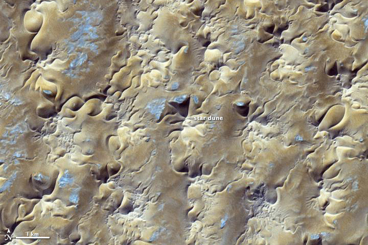
In some areas, winds tend to blow in roughly the same general direction all year. The Grand Erg Oriental, a sprawling sea of sand dunes in the Saharan Desert, is not one of them.

The winds in northeastern Algeria tend to be complex and changing. Easterly summer winds shift in the winter, becoming westerly. Meanwhile, passing storms and local geographical features further muddle the picture. If winds came consistently from one direction, crescent-shaped barchan dunes would reign. But the dominant dune type along the southern edge of Grand Erg Oriental (shown above) are large, pyramid-shaped star dunes, which only form in areas where winds blow from multiple directions.

The image was acquired by the Advanced Spaceborne Thermal Emission and Reflection Radiometer (ASTER) on NASA’s Terra satellite on October 27, 2012. Read more

NASA image courtesy NASA/GSFC/METI/ERSDAC/JAROS, and U.S./Japan ASTER Science Team. Caption by Adam Voiland.

The Advanced Spaceborne Thermal Emission and Reflection Radiometer (ASTER) on NASA’s Terra satellite captured this false-color image of the Rim fire burning in and near Yosemite National Park on August 30, 2013. The image, based on ASTER’s observations of visible and infrared light, highlights the contrast between burned and unburned vegetation. Unburned vegetation appears bright red, whereas burned areas are gray. Thick plumes of smoke are also visible billowing from the fire. Read more