CERES will be hosting the 29th annual CERES Science Team Meeting jointly with GERB and ScaRaB from September 10 – 13 at NCAR in Boulder, Colorado. The meeting will showcase scientific findings and plans for the studying Earth’s radiation and energy from space.


The EOS Flagship
Past News
- December 2025
- October 2025
- July 2025
- May 2025
- February 2025
- November 2024
- April 2024
- February 2024
- December 2023
- October 2023
- April 2023
- February 2023
- December 2022
- October 2022
- August 2022
- July 2022
- June 2022
- April 2022
- March 2022
- October 2021
- September 2021
- August 2021
- June 2021
- May 2021
- April 2021
- March 2021
- February 2021
- January 2021
- September 2020
- August 2020
- July 2020
- April 2020
- February 2020
- January 2020
- December 2019
- November 2019
- October 2019
- September 2019
- August 2019
- April 2019
- March 2019
- November 2018
- October 2018
- August 2018
- July 2018
- June 2018
- May 2018
- November 2017
- June 2017
- August 2016
- July 2016
- June 2016
- May 2016
- April 2016
- March 2016
- February 2016
- January 2016
- December 2015
- November 2015
- October 2015
- September 2015
- August 2015
- April 2015
- February 2015
- December 2014
- November 2014
- October 2014
- September 2014
- August 2014
- May 2014
- April 2014
- March 2014
- February 2014
- January 2014
- December 2013
- November 2013
- October 2013
- September 2013
- August 2013
- July 2013
- June 2013
- May 2013
- April 2013
- March 2013
- February 2013
- January 2013
- September 2012
- June 2012
- May 2012
- April 2012
- March 2012
- February 2012
- January 2012
News By Instrument
News By Science
- Air quality
- Applications
- Atmosphere
- Carbon Cycle and Ecosystems
- Climate Variability and Change
- Data
- Earth Observatory
- Earth's Surface and Interior
- Education
- Energy Cycle
- Events
- Human Dimensions
- LAADS DAAC
- Landsat
- Orbital Changes
- Platform
- Resources
- Terra Talent Series
- Terra Visits Camp Landsat
- VIIRS
- Water Cycle
- Weather
- Wildfire
Year: 2018
October 2018 VIIRS/MODIS Science Team Meeting
The upcoming combined MODIS/VIIRS Science Team Meeting will be held October 15-19, 2018 at the Sheraton Silver Spring Hotel, 8777 Georgia Avenue, Silver Spring, MD 20910. Accomplishments and plans for the future of MODIS and VIIRS will be discussed and shared. More information can be found on the MODIS Science Team Meeting website: https://modis.gsfc.nasa.gov/sci_team/meetings/201810/
The registration URL is available on-line at url: https://www.regonline.com/MODIS2018. Everyone is urged to complete registration by October 10th so that proper planning for attendance and logistics can be achieved. Indicate by clicking on the appropriate box(es) which portions of the meeting you are planning on attending. Agendas can also be accessed from the website once available.
15 years of MISR data show air pollution controls working in Southern California
New evidence shows that California’s clean air programs that reduce particle pollution in California are working.
Scientists from Emory University, NASA’s Jet Propulsion Laboratory, and the California Air Resources Board analyzed the 15-year trend of fine particle pollution based on satellite data from Terra’s Multi-angle Imaging SpectroRadiometer (MISR) instrument. This type of pollution, known as PM2.5 (less than 2.5 microns in diameter) accounts for the greatest percentage of health impacts attributable to air pollution in California.
The study was recently published in the journal “Atmospheric Environment” is the first to evaluate long-term changes in major PM2.5 components using spatially comprehensive satellite data, according the the California Air Resources Board.
Read the press release from the California Air Resources Board.
MISR Views Kilauea
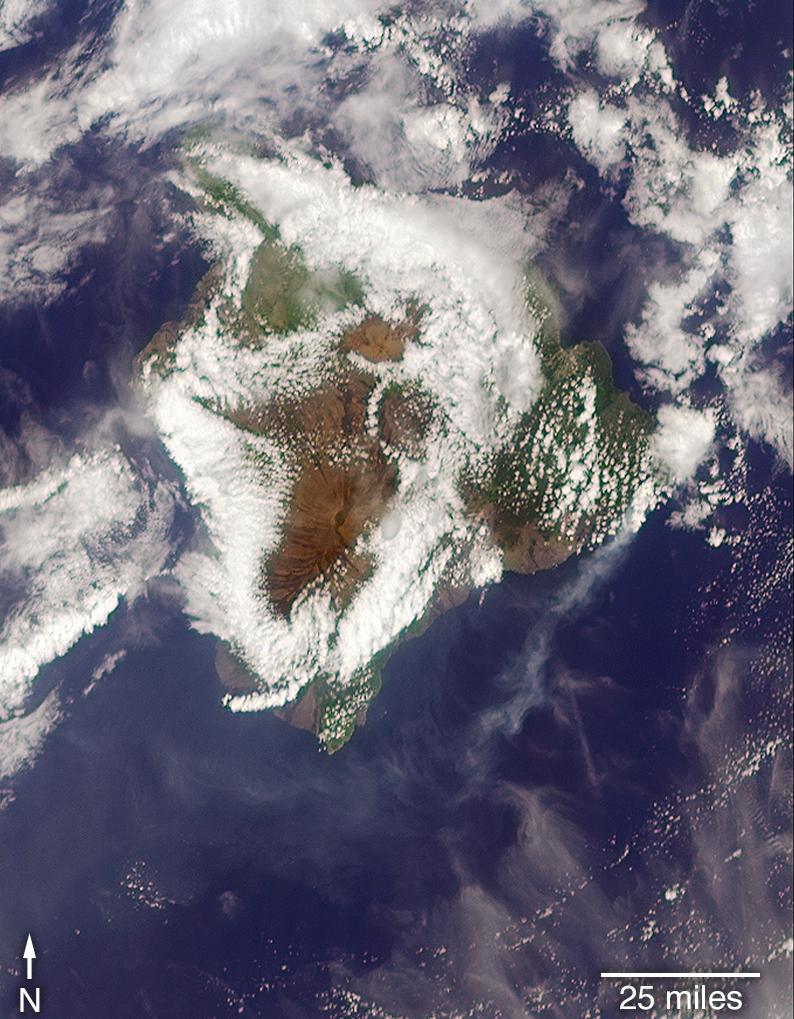
On May 6, 2018 as Kilauea continued to erupt, MISR passed overhead at approximately 11 a.m. local time, capturing this view of the island. While much of the island is covered by clouds, the eruption plume is visible streaming southwest over the ocean starting at the fissure on Hawaii’s eastern point. MISR uses it’s unique, nine-angle view to calculate plume height. This image is from one of MISR’s forward pointing cameras. The plume height is relatively low, meaning that gas and ash are staying near the ground, potentially causing health risks from poor air quality downwind.
Read more:
Ash from Kilauea Eruption Viewed by NASA’s MISR on NASA JPL’s Photojournal
ASTER Views Kilauea
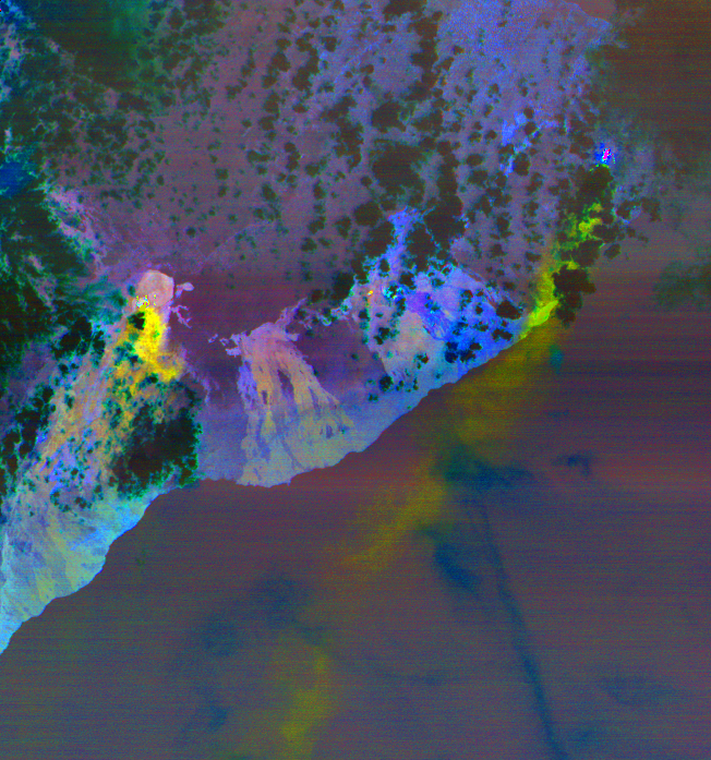
When volcanoes erupt, ASTER turns its attention to documenting the changes to the landscape as they happen. ASTER is uniquely capable of turning to see areas where volcanoes are erupting in very high resolution (between 15 in the thermal bands – 90 meter spatial resolution in the visible light spectral bands).
As Hawaii’s Kilauea continues to erupt, ASTER continues to monitor the eruption from space. This image from May 6, 2018 shows the sulfur dioxide being released from the volcano in yellow and yellow-green.
Read more:
Satellite View of Kilauea Eruption from NASA JPL