Year: 2016

timor_tmo_2016197

Cloud Streets over Timor Sea

July 24, 2016

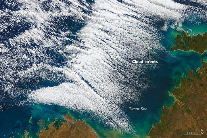
These “streets of the sky” called cloud streets are long parallel bands of cumulus clouds. On July 15, 2016, the Moderate Resolution Imaging Spectroradiometer (MODIS) on NASA’s Terra satellite aquired these images of cloud streets off the northern coast of Australia. Read more on NASA’s Earth Observatory.


labrador_mod_2016184

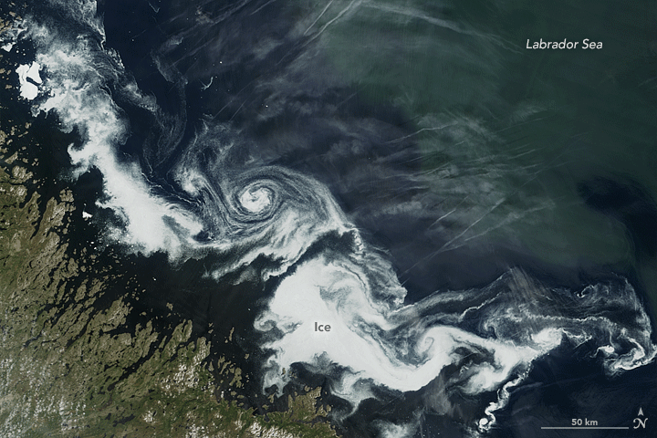
Swirls of Ice in the Labrador Sea

July 21, 2016

What first appeared to be a storm wasn’t a low pressure system in the clouds, but a swirling mass of ice in the sea. The Moderate Resolution Imaging Spectroradiometer (MODIS) on NASA’s Terra and Aqua satellites acquired views of an ice eddy off the coast of Labrador, Canada, on July 2, 2016. Read more on NASA’s Earth Observatory.


gypsymoth_tmo_2016178

Caterpillars Take Bite Out of Rhode Island Forests

July 15, 2016

Gypsy moth caterpillars damaged parts of New England’s forests and the damage is extensive enough to be seen from space. The Moderate Imaging Spectroradiomenter on NASA’s Terra satellite captured images of the damage over Rhode Island, Massachussetts and Connecticut during the pests’ population boom in the summer of 2016. Read more on  NASA’s Earth Observatory.


namibia_tmo_2016178

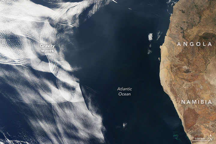
Making Waves in the Sky off of Africa

July 14 , 2016

On June 26, 2016, the Moderate Resolution Imaging Spectroradiometer (MODIS) on NASA’s Terra satellite acquired this natural-color image of cloud gravity waves off the coast of Angola and Namibia. Learn more about this phenomenon on NASA’s Earth Observatory.
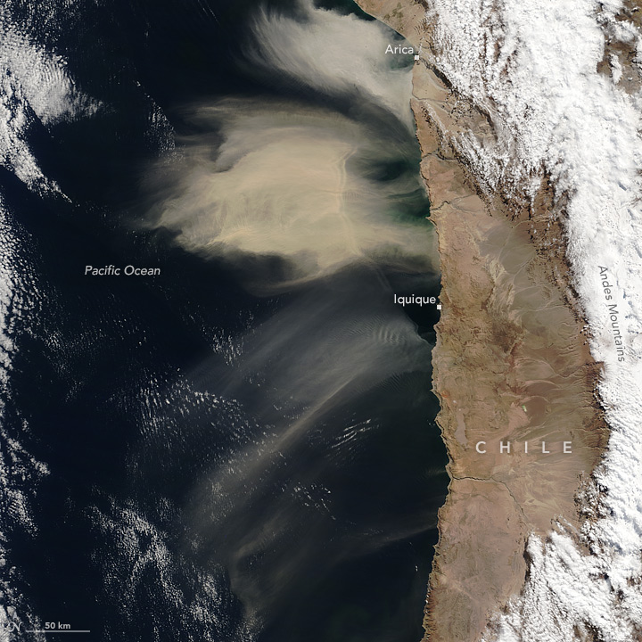

chile_tmo_2016190

Unusual Dust Off of Chile

July 12, 2016

Large amounts of dust were airborne off the west coast of South America. This is not a typical location dust events such as this one. The Moderate Resolution Imaging Spectroradiometer (MODIS) on NASA’s Terra satellite acquired this image of airborne dust off the coast of Chile, on July 8, 2016. Read more on NASA’s Earth Observatory.
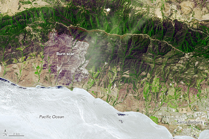

sherpafire_ast_2016171

Studying the Sherpa Fire

July 2, 2016

The Sherpa fire west of Santa Barbara, California was contained before it caused damage to homes or infrastructure. However, it still charred several thousand acres as of June 29. The Advanced Spaceborne Thermal Emission and Reflection Radiometer (ASTER) on the Terra satellite acquired an image of the burn scar on June 19, 2016. Read more on NASA’s Earth Observatory.


caspiansea_amo_2016158

Does Dust Affect Water Levels of the Caspian Sea

June 10, 2016

Dust storms over the Caspian Sea lead to increased evaporation and a drop in lake level according to new research using observations of dust collected by instruments on several satellites including the Moderate Imaging Spectroradiometer (MODIS ) and the Multi-angle Imaging Spectroradiometer (MISR) on Terra.


ruapehu_ast_2016111

A Satellite Eye on Mount Ruapehu

June 5, 2010

Mount Ruapehu is one of New Zealand’s most active volcanoes and most visited, dotted with skiers and snowboarders along its slopes.  When it erupts lahars, flows of volcanic debris and sediment, can have devastating impacts, prompting geologists to regularly monitor the volcano, using the Advanced Spaceborne Thermal Emission and Reflection Radiometer on NASA’s Terra satellite.


roanu_tmo_2016142

The Rains of Roanu

May 24, 2016 

Tropical Storm Roanu made landfall in Bangladesh, unleashing heavy winds and rain on the country’s populous coastal communities. On May 21, 2016, the Moderate Resolution Imaging Spectroradiometer (MODIS) on NASA’s Terra satellite acquired this natural-color image of the storm. Roanu progressed northeast over the Bay of Bengal before making landfall in Bangladesh.


beaufort_tmo_2014092-2016117

Early Breakup of the Beaufort Sea Ice 

May 20, 2016 

The Beaufort Sea ice pack starts to thin and break up in spring when temperatures begin to rise, usually in late May. However, much of the Beaufort Sea’s ice had already broken by mid-April. Images from the Moderate Imaging Spectroradiometer (MODIS) on NASA’s Terra satellite captured the progression in April in 2014, 2015, and 2016.


greenlandlsta_tmo_201604

Widespread Warmth Envelops Greenland 

May 18, 2016

Land surface temperature data from the Moderate Imaging Spectroradiometer on NASA’s Terra satellite shows a much warmer than average April in Greenland.


canadalsta_tmo_2016126

Heat Fuels Fire at Fort McMurray

May 7, 2016 

Land surface data from the Moderate Resolution Imaging Spectroradiometer showed increased land surface temperatures near Fort McMurray in Northern Alberta, Canada, where a destructive wildfire burned.


thailandlsta_tmo_201604

Heat Wave Hits Thailand, India

May 4, 2016

Land surface temperature map based on data from the Moderate Imaging Spectroradiometer on NASA’s Terra satellite shows a warmer than average Southeast Asia in April.

McMurray 720_MODIS_06052016

fort_mcmurray_NRT+AOD_col_d[7]
NASA  Images from NASA Worldview (above) and created with data from MOPITT and MODIS (below) provided by the MOPITT Science Team. Caption by Sara Martinez-Alonso with Tassia Owen.

May 24, 2016
The Fort McMurray wildfire in Alberta, Canada not only had devastating impacts on its community, but the effect on air quality was also far reaching. Along with drifting smoke, wildfires cause increases in atmospheric carbon monoxide levels.

These maps were produced using data acquired by MOPITT and MODIS, two of the instruments on board NASA’s Terra satellite. These maps document the extent and composition of the Fort McMurray fire plume on May 6th and 7th.

MOPITT measures tropospheric carbon monoxide (CO). CO is mostly produced by incomplete fuel combustion, biomass burning, and oxidation of methane and other hydrocarbons. Shown here are MOPITT retrievals of CO total column generated in near real-time for use in the ECMWF MACC-III global data assimilation and forecasting system.

MODIS analyzes, among others, atmospheric aerosols, one of the greatest sources of uncertainty in climate modeling. The MODIS map shown here depicts aerosol optical depth (AOD), a measure of the extinction of solar light by atmospheric particles.

The similarity in the features shown in the two maps is quite obvious. The plume originates near Fort McMurray (shown with an asterisk) and extends mostly southeast for more than 1000 miles (1600 km), crossing state and country boundaries.

April 26, 2016

A Sudden Color Change on Lake KivuThe Moderate Imaging Spectroradiometer (MODIS) on NASA’s Terra Satellite captured images of a whiting event in Lake Kivu. The seasonal event is stronger this year, giving Lake Kivu a milky color. 


April 22, 2016

Using Clouds to Map Life – A team of researchers are using cloud data from the Moderate Imaging Spectroradiometer (MODIS) on NASA’s Terra Satellite to create detailed maps of cloud cover and variability. The team found that cloud cover could be an indicator and a better predictor of a songbird and flower’s range than temperature and precipitation.


April 17, 2016

Yellowstone National Park – Learn about Yellowstone National Park and view an image made possible by the Digital Elevation Model from the Advanced Spaceborne Thermal Emission and Reflection Radiometer (ASTER) on NASA’s Terra satellite.


April 14, 2016

Sierra Nevada Snowpack is Better, But not Normal – Snowpack in the Sierra Nevada mountains dwindled over recent years; however, the winter of 2015-2016 and the strong El Nino provided a thicker and more extensive snowpack. Regardless, snow levels in the Sierra Nevada mountains were still below average. Images from NASA’s Moderate Imaging Spectroradiometer (MODIS) clearly show the difference between years.


April 13, 2016

Antarctic Ice Shelf Sheds Bergs – The Moderate Imaging Spectroradiometer on NASA’s Terra Satellite captured this striking image of the formation of two new icebergs as they broke away from the Nansen Ice Shelf into the Southern Ocean on April 7, 2016.


April 9, 2016

Greening Ascension Island – When Charles Darwin first visited Ascension Island it was barren, but with the assistance of Joseph Hooker in the 1800s plants were introduced and now cover much of this once bleak island. The image from the Advanced Spaceborne Thermal Emissions and Reflection Radiometer (ASTER) on NASA’s Terra satellite shows the now green Ascension Island and it’s Green Mountain.


April 3, 2016

Pavlov Erupts Again – Pavlov Volcano, Alaska’s most active volcano, began erupting for the first time since November 2014. The Moderate Resolution Imaging Spectroradiometer (MODIS) instruments on NASA’s Terra and Aqua satellites acquired images of the ash plume at 11:45 a.m on March 28, 2016.