Year: 2014

sulaiman_ast_2011114_imbricate

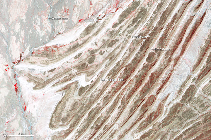
While not as high as the Himalayas or Karakoram, the Sulaiman range boast some of the most complex tectonic structures in the world. As India moved northward, it began to rotate in a counter-clockwise direction, wrenching the northwestern part of the Indian plate backwards into part of the Eurasian plate. The countervailing forces put the rocks of the Sulaiman range in a unique compressional vice, causing many of its faults to curve and stretch in convoluted ways.

The Advanced Spaceborne Thermal Emission and Reflection Radiometer (ASTER) instrument on NASA’s Terra satellite captured a scene on April 24, 2011, that highlights some of this tectonic complexity. Read more

NASA Earth Observatory image by Robert Simmon and Adam Voiland, with data courtesy of NASA/GSFC/METI/ERSDAC/JAROS, and the U.S./Japan ASTER Science Team. Caption by Adam Voiland.

RedSea_tmo_2014189

Dust and sand storms are not unusual in North Africa and western Asia; in fact, they are a regular part of the region’s rhythm and observed often by satellites. But familiarity does not make them any less extraordinary.

The Moderate Resolution Imaging Spectroradiometer (MODIS) on NASA’s Terra satellite captured this image at 11:25 a.m. local time (0825 Universal Time) on July 7, 2014. A thick plume of dust was blowing out from the dry interior of Sudan and across hundreds of kilometers of the Red Sea, with smaller plumes also visible over Saudi Arabia and Eritrea. Prevailing northwest winds over the water blew the plumes to the southeast. Read more

NASA image courtesy Jeff Schmaltz, LANCE/EOSDIS MODIS Rapid Response Team at NASA GSFC. Caption by Mike Carlowicz.

Canada_tmo_2014188_detail


A combination of lightning and dry forests fueled numerous wildfires in Canada’s Northwest Territories in July 2014. The fires, burning in Canada’s boreal zone, are producing dense smoke. As of July 8, at least 164 blazes had charred more than 425,172 hectares (1,642 square miles), according to the Canadian government. The fires destroyed one home, forced hundreds of people to evacuate, and sent smoke drifting as far south as the continental United States.

The Moderate Resolution Imaging Spectroradiometer (MODIS) on NASA’s Terra satellite captured this image of smoke billowing from wildfires near Faber Lake on July 7, 2014. Read more

NASA image courtesy Jeff Schmaltz, LANCE/EOSDIS MODIS Rapid Response Team at NASA GSFC. Caption by Adam Voiland.


neoguri_tmo_2014190

Typhoon Neoguri pounded Okinawa and other Western Pacific islands with torrential rain and damaging winds in mid-July 2014, en route to a likely landfall in Japan. The Visible Infrared Imaging Radiometer Suite (VIIRS) on the Suomi NPP satellite captured a nighttime image of the storm at 2:07 a.m. Japan Standard Time on July 9, 2014 (17:07 Universal Time on July 8). At the time, Neoguri was a category 2 typhoon moving through the East China Sea.

The storm was imaged by a special “day-night band” that detects light in a range of wavelengths from green to near-infrared and uses light intensification to detect dim signals. The instrument can sense light as much as 100,000 times fainter than conventional visible-light sensors, making it very sensitive to moonlight and city lights. In this case, the cloud tops were lit by the nearly full Moon.

The Moderate Resolution Imaging Spectroradiometer (MODIS) on NASA’s Terra satellite captured a natural-color image of Neoguri at 11:30 a.m. local time (0230 Universal Time) on July 9, 2014. Read more

Terra MODIS image by Jeff Schmaltz, LANCE/EOSDIS Rapid Response. Caption by Michael Carlowicz.

pilger_ast_2014172

On June 16, 2014, a tornadic thunderstorm system moved across portions of northeast Nebraska, producing 5 tornadoes. Four of the tornadoes were rated as EF-4 on the Enhanced Fujita Scale, meaning that they were violent tornadoes with winds between 166 and 200 miles per hour. One EF-4 tornado spun directly through Pilger, Nebraska, a small town of 350 people, leveling much of the town.

The Advanced Spaceborne Thermal Emission and Reflection Radiometer (ASTER) instrument aboard NASA’s Terra satellite captured the top image of northeast Nebraska on June 21, 2014. Two of the EF-4 tornado tracks are visible in the false-color image (near-infrared, red, green). The tracks are tan paths of bare ground across plant-covered fields, which are red. The towns of Pilger and Wisner are bright white. The lower image, also from the ASTER instrument, shows the region on July 4, 2013. Turn on the comparison tool to contrast the before and after views. Read more

NASA Earth Observatory image by Jesse Allen, using data from NASA/GSFC/METI/ERSDAC/JAROS, and U.S./Japan ASTER Science Team. Caption by Kari Beckendorf and Holli Riebeek.