Category: News and Events

News and Events

NASA image courtesy Jeff Schmaltz, LANCE/EOSDIS MODIS Rapid Response Team at NASA GSFC. Caption by Holli Riebeek.

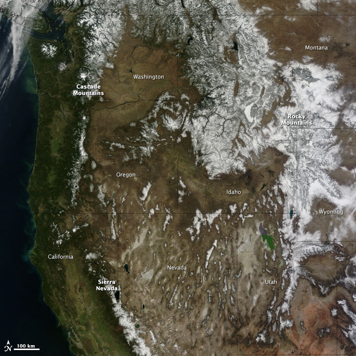
The winter of 2013–2014 was a study in contrasts between mountains in the far western United States and in the interior West. While people waited in vain for winter snow in California and the Pacific Northwest, snow piled onto the Rocky Mountains in Montana and Wyoming. The contrast is embodied in this image, acquired by the Moderate Resolution Imaging Spectroradiometer (MODIS) on NASA’s Terra satellite on March 12, 2014. Read more

NASA image courtesy Jeff Schmaltz, LANCE/EOSDIS MODIS Rapid Response Team at NASA GSFC. Caption by Holli Riebeek.

Terra, among a  satellites  from many nations, joined the effort in the search for Malaysian Airlines Flight MH-370. Read more

NASA image courtesy Jeff Schmaltz, LANCE/EOSDIS MODIS Rapid Response Team at NASA GSFC. Caption by Adam Voiland.

Rarely do weather patterns and satellite overpass schedules align to provide cloud-free views of Western Europe in the spring. However, a high-pressure pattern kept skies spectacularly clear over the Iberian Peninsula and east into France and Germany as the Moderate Resolution Imaging Spectroradiometer (MODIS) on NASA’s Terra satellite passed over on March 8, 2014. The cloud-free area began to emerge on March 5 and persisted through March 11. Explore Worldview—a near-real time browser from the MODIS Rapid Response Team—to see a wider view and how the cloud-free area changed over time. Read more

NASA image courtesy Jeff Schmaltz, LANCE/EOSDIS MODIS Rapid Response Team at NASA GSFC. Caption by Adam Voiland.

      NASA Earth Observatory images by Jesse Allen, using MODIS data from the Land Processes Distributed Active Archive Center (LPDAAC). Caption by Michael Carlowicz.

For many residents of North America, the winter of 2013-14 has felt like one of the coldest in many years. Waves of Arctic air brought extended periods of cold weather and above-average snowfall to the middle and eastern portions of the United States and Canada. Seven Midwestern states had one of their top-ten coldest winters, and the Great Lakes were chilled until they reached nearly 91 percent ice cover. Even portions of Mexico and Central America were cooler than normal. Read More

NASA Earth Observatory images by Jesse Allen, using MODIS data from the Land Processes Distributed Active Archive Center (LPDAAC). Caption by Michael Carlowicz.

NASA images courtesy Jeff Schmaltz, LANCE/EOSDIS MODIS Rapid Response Team at NASA GSFC. Caption by Holli Riebeek.

A low-pressure system brought strong winds—gusting to 55 miles (85 kilometers) per hour—to the Southern Plains on March 18, 2014. The winds picked up exposed soil from the parched landscape, resulting in a large dust storm that covered parts of Colorado, Kansas, Oklahoma, New Mexico, and Texas. The storm was the second in the past week to sweep across the region with similar wind patterns.

The Moderate Resolution Imaging Spectroradiometer (MODIS) acquired this image of the storm on March 18. The top image shows the dust over the Texas Panhandle at 1:15 p.m. Central Daylight Time from the MODIS instrument on NASA’s Terra satellite. Read more

NASA images courtesy Jeff Schmaltz, LANCE/EOSDIS MODIS Rapid Response Team at NASA GSFC. Caption by Holli Riebeek.