ASTER Helps Map Ancient Settlements in Mesopotamia
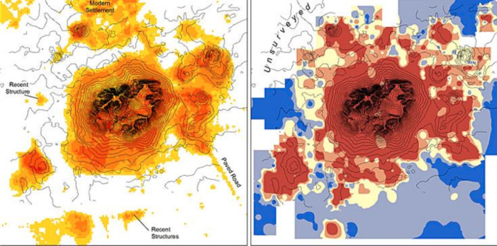
A comparison of ASTER classification (left) and surface artifact distribution (right). In the image on the left yellow indicates a greater than fifty percent probability of finding artifacts and bright orange indicates that the probability is greater than eighty percent. In the image on the right blue indicates that there are less than two artifacts per square meter and red indicates that there are more than ten. Image courtesy of Bjoern Menze and Jason Ur
Remote sensing technology can be applied to archaeological survey methods helping archaeologists find sites and map the locations of past civilizations. However, the location alone is not enough to create an extensive and intensive record revealing the cycles of rising and falling settlements over many millennia. Two Harvard archealogists used remotely sensed data from ASTER and CORONA, to create a map that not only reflects the location of ancient civilizations, but also provides insight into the number of people living at each site and how often different sites were inhabited. Through identifying the volume of anthropogenic soils, or soils modified by humans, scientists were able to make a more complete record of the changing landscape of Mesopotamia over time. The CORONA program produced photographs that made it possible for the scientists to locate mounds of earth thought to be made by human settlement, but other satellite and aerial photography images needed to be used to create a more complete map. These images were then combined with multispectral images from satellite instruments including ASTER, which made it possible to determine whether or not the mounds contained anthropogenic soils. Using this technique, the scientists were able to create one of the largest systematic remote sensing records for an ancient landscape, including over fourteen thousand sites and covering approximately 22,000km2.
Menze, Bjoern and Ur, Jason. (2012, March 19). Mapping patterns of long-term settlement in Northern Mesopotamia at a large scale. Proceedings of the National Academy of Sciences.


