Tag: MISR

MISR News and Events

100-remote-sensing-uses-logo-top

Image from GIS Geography. 100 Earth Shattering Uses and Applications of Remote Sensing.

GIS Geography published a list of 100 uses and applications of remote sensing, where data from NASA’s Terra satellite appeared in over 10%.

Listed below are some examples of Terra data uses that made the list (numbered by their original order in the article from GIS Geography):

13. Identifying forest stands and tallying their area to estimate forest supplies (MODIS)

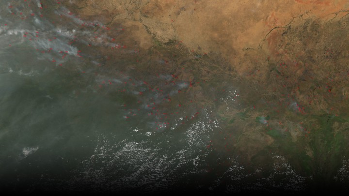
26. Fighting wildfires by planning firefighter dispatch (MODIS)

27. Monitoring air quality in the lower atmosphere (MOPITT)

38. Keeping tabs on the shift from rural to urban growth (MODIS)

39. Quantifying crop conditions with Normalized Difference Vegetation Index (NDVI from MODIS)

59. Monitoring active volcanoes using thermal remote sensing (ASTER, MISR, and MODIS)

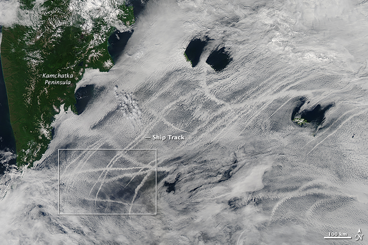
66. Looking at the Earth as an art masterpiece NASA’s Earth as Art | NASA Visible Earth

70. Comparing climatic factors from past to present (MODIS, CERES, MOPITT)

75. Studying geology of the Earth’s surface (ASTER, MISR, MODIS)

77. Measuring albedo for Earth’s radiation budget (CERES)

83. Delineating watersheds using DEMs for hydrologists (ASTER)

85. Using a least-cost analysis and vegetation to understand wildebeest migration (NDVI from MODIS)

Read the whole list and learn more about each of the uses and applications of remote sensing at 100 Earth Shattering Remote Sensing Applications Uses from GIS Geography

earth20150806b-16

The Moderate Resolution Imaging Spectrometer (MODIS) instrument on NASA’s Aqua satellite captured this image of numerous fires burning in the transition zone between the Sahara Desert to the north and the greener savannas to the south. The image, dating from November 2004, includes parts of Sudan, Chad and other nations to the south and west. Image credit: NASA

A new study is the first to use satellite observations to look at how smoke affects rainfall. Specifically focusing on agricultural fires in North Africa that reduce the amount of rainfall during the dry season.

African agricultural fires, a major source of fires globally, are used to increase agricultural productivity and clear land for farming.  Large plumes are formed by these fires, impacting weather and precipitation patterns, while carrying nutrients to land and ocean regions downwind.

Using satellite data from three NASA satellites from varying passover times along with weather records, Michael Tosca and his colleagues from NASA’s Jet Propulsion Laboratory in Pasadena, California, assessed how microscopic smoke particles affect the formation of clouds and rainfall in Africa, north of the equator and south of the Saharan Desert.

Using images of smokey areas taken by  the Multi-angle Imaging Spectroradiometer instrument (MISR) on-board Terra from 2006 to 2010, Tosca and his colleagues were able to match “each smoky image with a smoke-free scene in statistically identical weather conditions.” From this information they compared the changing cloud cover throughout the day, using data from Tropical Rainfall Measuring Mission (TRMM) and Aqua, which pass over the same region at later times in the day.

Clouds need small airborne particles, aerosols, to act as a nucleus on which water vapor can condense and form clouds. Black carbon, a common aerosols in African fires, absorbs radiation from the sun and heats up the surrounding air.  When a layer of this soot-filled warm air forms, rising air from Earth’s surface is blocked by the warm layer, causing air from Earth’s surface to spread out horizontally. Rain clouds are produced from air moving up in updrafts and then condensing and falling, a process called convection.  When the air cannot penetrate the soot-filled layer, rain cloud formation is suppressed. “The researchers found that less cloud cover built up throughout the day in smoky scenes than in scenes without smoke.”

The NASA press release is available online at: http://www.jpl.nasa.gov/news/news.php?feature=4681

The study is available online at: http://onlinelibrary.wiley.com/doi/10.1002/2015GL065063/full

Read More on NASA’s Earth Observatory

PacificOcean_amo_2015208 A scientist, Yi-Chun (Jean) Chen, at NASA’s Jet Propulsion Laboratory, and his colleagues were able to show how open-cell versus closed cell clouds affect the brightness, or albedo, of ship tracks.

Using data from MODIS on-board both Aqua and Terra and from the Multi-angle Imaging SpectroRadiometer (MISR) on Terra, the team studied the relationship between ship-emitted aerosols and cloud properties. The results suggested that aerosol plumes increased the amount of clouds and albedo in open-cell formation areas; where as, areas with closed-cells were less susceptible to aerosol plumes.

Research available in the April 2015 Journal of Geophysical Research

Read more on NASA’s Earth Observatory


The Advanced Spaceborne Thermal Emission and Reflection Radiometer (ASTER) is a 15-channel imaging instrument operating on NASA’s Terra satellite. A joint project between the U.S. National Aeronautics and Space Administration and Japan’s Ministry of Economy, Trade, and Industry, ASTER has been acquiring data for 15 years, since March 2000. The archive now contains over 2.8 million scenes; for the majority of them, a stereo pair was collected using nadir and backward telescopes imaging in the NIR wavelength.The majority of users require only a few to a few dozen scenes for their work. Studies have ranged over numerous scientific disciplines, and many practical applications have benefited from ASTER’s unique data. A few researchers have been able to mine the entire ASTER archive, that is now global in extent due to the long duration of the mission. Six examples of global products are described in this contribution:the ASTER Global Digital Elevation Model (GDEM), the most complete, highest resolution DEM available to all users; the ASTER Emissivity Database (ASTER GED), a global 5-band emissivity map of the land surface; the ASTER Global Urban Area Map (AGURAM), a 15-m resolution database of over 3500 cities;the ASTER Volcano Archive (AVA), an archive of over 1500 active volcanoes; ASTER Geoscience products of the continent of Australia; and the Global Ice Monitoring from Space (GLIMS) project.

Access the complete article on International Journal of Applied Earth Observation and Geoinformation

Student winners of NASA’s 2014 educational “REEL Science Communication Contest” have completed their follow-on Earth science videos after a month-long workshop with NASA scientists and communication experts.

In May of 2014, NASA Earth science missions at NASA’s Goddard Space Flight Center in Greenbelt, Maryland, selected winners of their second annual video contest for high school students. The student winners each produced two-minute videos that communicate NASA Earth science to engage younger students. Winners were awarded the opportunity to work remotely with NASA experts to create new Earth science videos for NASA outreach.

Throughout July, contest winners Lena Korkeila from Placerville, California; Anna and Geof Olson from Santa Cruz, California; and Heather Forster, Sofia Bialkowski and Suzie Petryk from Huntington, New York, learned about NASA Earth science missions, communication efforts and video production.  Working with people from the Terra, Aqua and ICESat-2 Earth science missions and Goddard’s Office of Communications, the students pitched video ideas, wrote their scripts, identified NASA footage and visualizations, found or created accompanying music and recorded their narrations. Read more