The Terra Satellite is currently back in operation. MODIS, MISR and CERES are all collecting data. Terra’s international sensors, MOPITT and ASTER, will begin collecting data soon.


The EOS Flagship
Past News
- December 2025
- October 2025
- July 2025
- May 2025
- February 2025
- November 2024
- April 2024
- February 2024
- December 2023
- October 2023
- April 2023
- February 2023
- December 2022
- October 2022
- August 2022
- July 2022
- June 2022
- April 2022
- March 2022
- October 2021
- September 2021
- August 2021
- June 2021
- May 2021
- April 2021
- March 2021
- February 2021
- January 2021
- September 2020
- August 2020
- July 2020
- April 2020
- February 2020
- January 2020
- December 2019
- November 2019
- October 2019
- September 2019
- August 2019
- April 2019
- March 2019
- November 2018
- October 2018
- August 2018
- July 2018
- June 2018
- May 2018
- November 2017
- June 2017
- August 2016
- July 2016
- June 2016
- May 2016
- April 2016
- March 2016
- February 2016
- January 2016
- December 2015
- November 2015
- October 2015
- September 2015
- August 2015
- April 2015
- February 2015
- December 2014
- November 2014
- October 2014
- September 2014
- August 2014
- May 2014
- April 2014
- March 2014
- February 2014
- January 2014
- December 2013
- November 2013
- October 2013
- September 2013
- August 2013
- July 2013
- June 2013
- May 2013
- April 2013
- March 2013
- February 2013
- January 2013
- September 2012
- June 2012
- May 2012
- April 2012
- March 2012
- February 2012
- January 2012
News By Instrument
News By Science
- Air quality
- Applications
- Atmosphere
- Carbon Cycle and Ecosystems
- Climate Variability and Change
- Data
- Earth Observatory
- Earth's Surface and Interior
- Education
- Energy Cycle
- Events
- Human Dimensions
- LAADS DAAC
- Landsat
- Orbital Changes
- Platform
- Resources
- Terra Talent Series
- Terra Visits Camp Landsat
- VIIRS
- Water Cycle
- Weather
- Wildfire
Year: 2016
MODIS’s New Vegetation Index: Ecosystem Sensitivity and Climate Variability
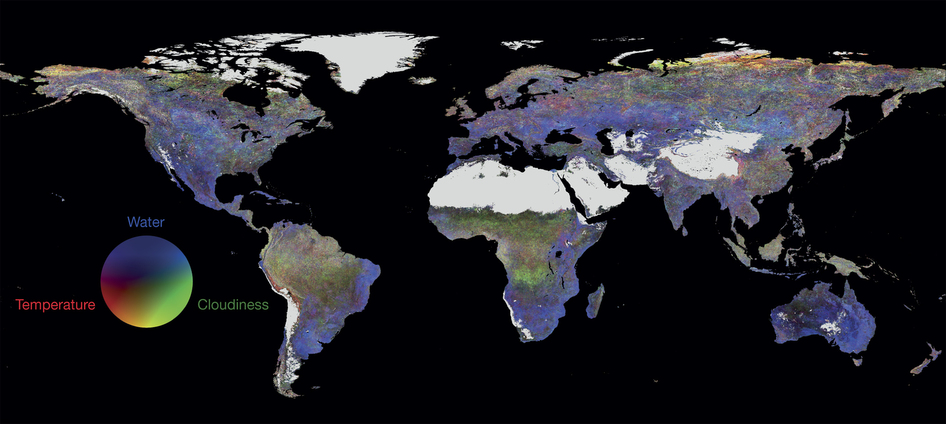
Global contribution of three climate variables to the vegetation sensitivity index from 2000–2013. Temperature is in red, water availability in blue and cloudiness in green. Areas with dominant barren land and permanent ice are grey. Image credit: Sensitivity of global terrestrial ecosystems to climate variability. Alistair W. R. Seddon, Marc Macias-Fauria, Peter R. Long, David Benz & Kathy J. Willis. Nature. (2016) doi:10.1038/nature16986
MODIS data from the past 14 years is being used to generate a model that assesses how different ecosystems respond to climate variability, making it possible to compare regional sensitivity and resilience. The new index is called the vegetation sensitivity index, which makes it possible to compare vulnerability of different regions, looking at why some areas are more vulnerable than others.
The new index is unique. Most studies about ecosystem resilience typically monitor productivity or biodiversity trends over an average climate, such as the normalized difference vegetation index (NDVI) or the enhanced vegetation index (EVI), which also uses MODIS data. This new index instead looks at response to climate variation.
Read the news article from Nature.
Read the journal article from Nature.
Terra on the Earth Observatory: February
February 19, 2016
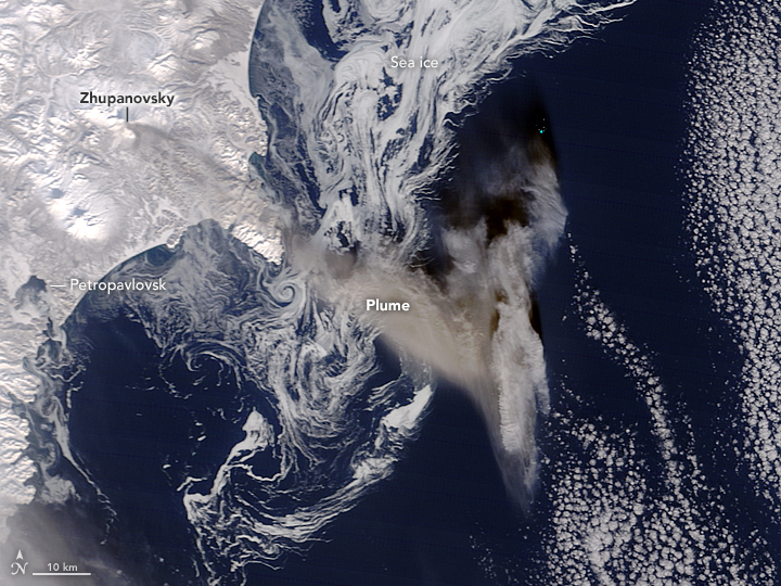
Ash Plume and Sea Ice Near Zhupanovsky – Since October, 2015 Zhupanovsky volcano in far eastern Russia has periodically been spewing ash into the atmosphere. This MODIS image from February 13, 2016 shows an ash plume from Zhupanovsky volcano, which resulted in a code-red for air travel in the region.
February 12, 2016
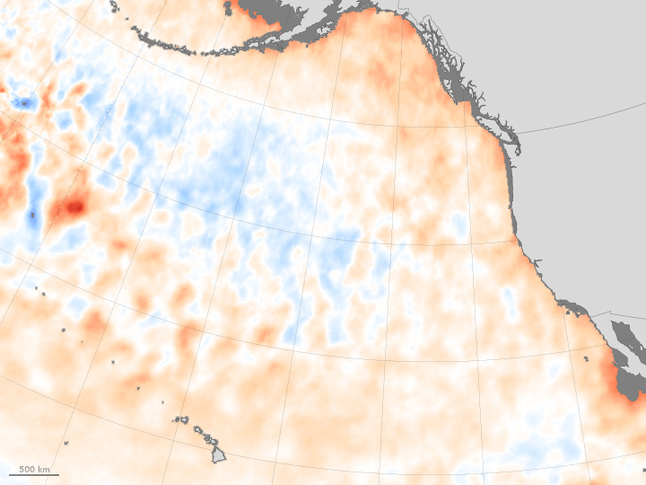
The Demise of the Warm Blob – Ocean surface temperatures, showed a warm “blob” off the northern United State’s coast. This cell of warm ocean water in the Pacific Ocean no longer is present, having lasted from the winter of 2013 through December of 2015.
February 17, 2016
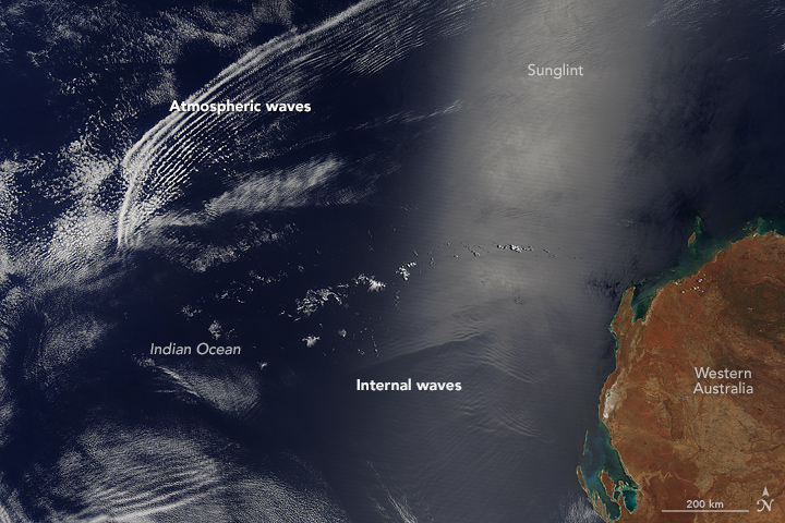
Waves Above and Below the Water – The Moderate Imaging Spectroradiometer on NASA’s Terra satellite acquired an image of wave patterns in the sky and in the water off the coast of Western Australia.
February 11, 2016
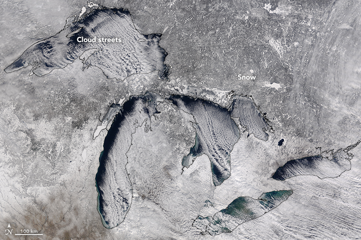
Cloud Streets Over the Great Lakes – MODIS captured this image of cloud streets crossing the Great Lakes.
February 10, 2016
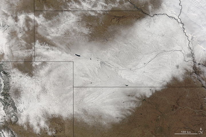
Snow in the Central U.S. – Snow from a blizzard blanketed parts of the Midwest. This image from Terra’s Moderate Imaging Spectroradiometer (MODIS) captured the snow that remained after the clouds cleared over Nebraska.
February 6, 2016
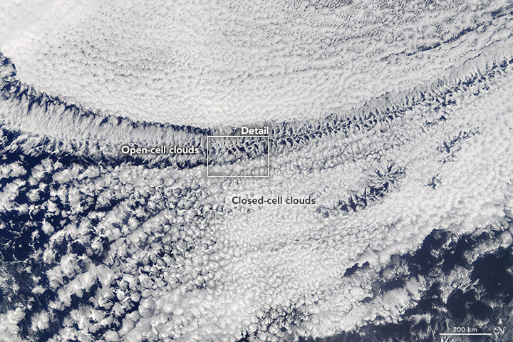
Open- and Closed-Celled Clouds over the Pacific – Terra’s Moderate Imaging Spectroradiometer (MODIS) captured in one image examples of two different types of convective clouds, open-celled and closed-celled.
February 5, 2016
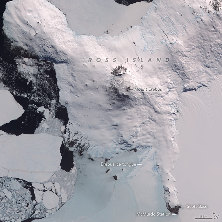
Mount Erebus, Antarctica – Mount Erebus in Antarctica, thought to be the most southern volcano is still active. The Advanced Spaceborne Thermal Emissions and Reflection Radiometer (ASTER) on NASA’s Terra satellite captured images in visible and infrared, showing not just the volcano, but also the lava lake in its interior.
February 3, 2016
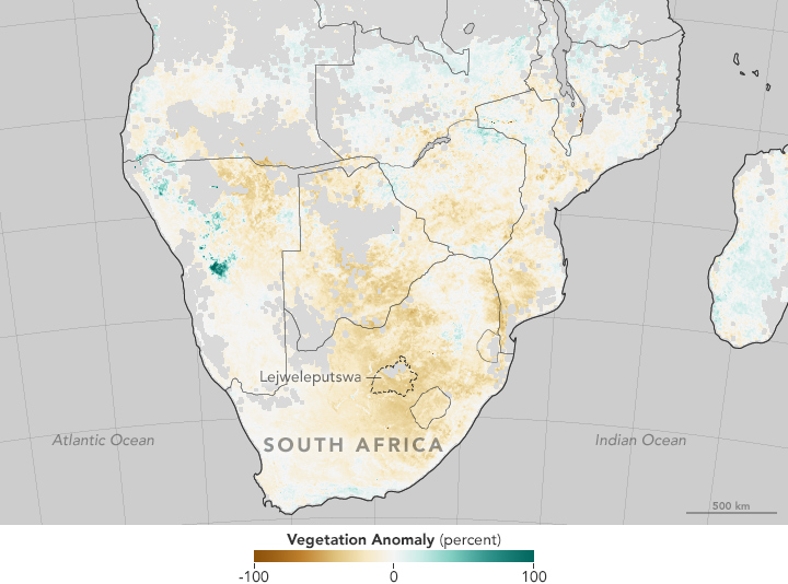
Drought in Southern Africa – Normalized Difference Vegetation Index (NDVI) data from Terra’s Moderate Imaging Spectroradiometer (MODIS) sensor are being used to track drought conditions in southern Africa, analyzing the effects of the current strong El Niño on vegetation.
Congratulations, ESA on the Launch of Sentinel 3A!
Sentinel-3A, the European Space Agency (ESA) – developed Earth observing satellite successfully launched on February 16, 2016. Sentinel-3A is part of Europe’s Copernicus environment program and carries four sensors: The Sea and Land Surface Temperature Radiometer (SLSTR), the Ocean Land Colour Instrument (OLCI), the Synthetic Aperture Radar (SAR) Altimeter, and the microwave radiometer.
Researchers who use Terra MODIS data are particularly interested in OLCI. OLCI images the earth similarly to MODIS on NASA’s Terra and Aqua satellites. It measures specific ocean color, vegetation and atmospheric measurements at 300m spatial resolution and at 1270 km swath width. Sentinel 3A has a morning crossing time like Terra, making Sentinel-3A the most similar to Terra satellite currently flying. Like MODIS data, Sentinel data will be free of charge and provided worldwide.
Congratulations, ESA!
New environmental observation methods see the forest for the trees
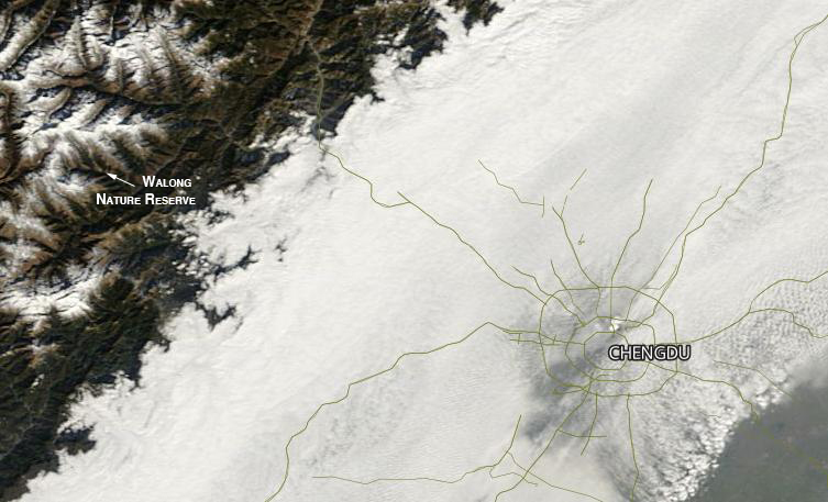
Researchers at Michigan State University’s Center for Systems Integration and Sustainability are combining images from Moderate Resolution Imaging Spectroradiometer (MODIS) and Landsat with information taken on the ground, to increase understanding of how biodiversity is changing in China’s Wolong Nature Reserve, home to the giant panda.
Read the whole article from Michigan State University.