NASA image by Jeff Schmaltz, LANCE/EOSDIS Rapid Response. Caption by Kathryn Hansen.
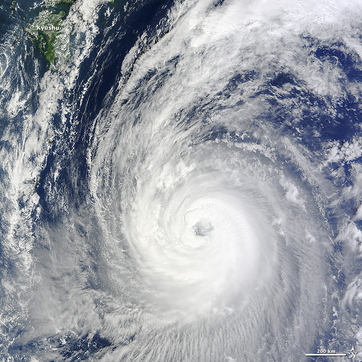
Forecasts indicate that Japan can expect widespread rain as Typhoon Phanfone nears the nation over the weekend. The Moderate Resolution Imaging Spectroradiometer (MODIS) on NASA’s Terra satellite acquired this natural-color view of the category 3 storm at 10:55 a.m. Japan Standard Time (01:55 Universal Time) on October 3, 2014. Read more
NASA image courtesy Jeff Schmaltz, LANCE MODIS Rapid Response Team at NASA GSFC. Caption by Mike Carlowicz.
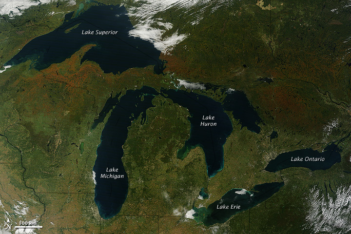
A few days after autumn showed up on the calendar in the Northern Hemisphere, it showed up on the landscape of North America. The Moderate Resolution Imaging Spectroradiometer (MODIS) on NASA’s Terra satellite captured these views of fall colors around the Great Lakes (September 26) and New England (September 27, 2014). The brown and orange shades are most pronounced in the Upper Peninsula of Michigan, northern Wisconsin, upstate New York, New Hampshire, Vermont, Maine, and southern Quebec and Ontario. You can also see faint traces of phytoplankton blooms in the lakes and offshore in the North Atlantic.
The changing of leaf color in temperate forests involves several causes and reactions, but the dominant factors are sunlight and heat. Since temperatures tend to drop sooner and sunlight fades faster at higher latitudes, the progression of fall color changes tends to move from north to south across North America from mid-September through mid-November. Read more
See an animation of the changing colors on this article from the Huffington Post.
NASA Earth Observatory image by Jesse Allen, using data from the Level 1 and Atmospheres Active Distribution System (LAADS). Caption by Kathryn Hansen.
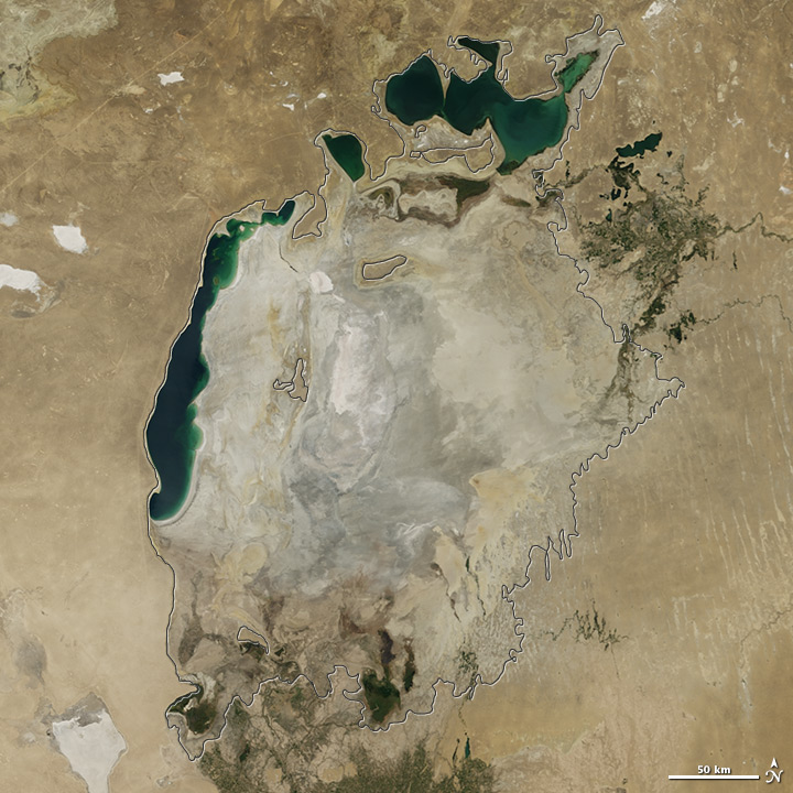
Summer 2014 marked another milestone for the Aral Sea, the once-extensive lake in Central Asia that has been shrinking markedly since the 1960s. For the first time in modern history, the eastern basin of the South Aral Sea has completely dried.
This image pair from the Moderate Resolution Imaging Spectroradiometer (MODIS) on NASA’s Terra satellite shows the sea without its eastern lobe on August 19, 2014. Read more
NASA image by Jeff Schmaltz, LANCE/EOSDIS Rapid Response. Caption by Kathryn Hansen.
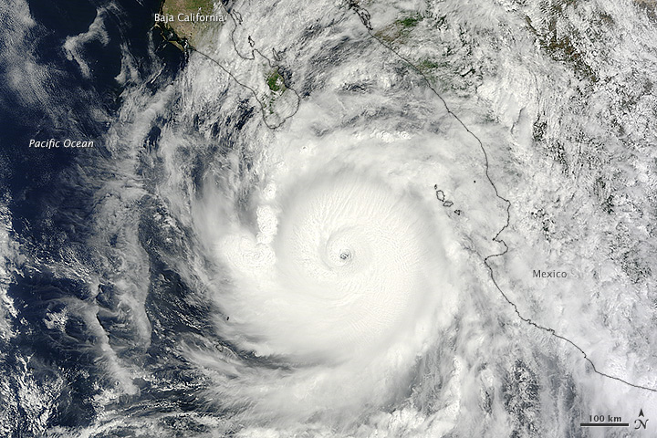
At about 10:45 p.m. Mountain Daylight Time (MDT) on September 14, 2014, Hurricane Odile made landfall as a Category 3 storm near Cabo San Lucas, Mexico. According to the U.S. National Hurricane Center, Odile arrived with wind speeds of 110 knots (204 kilometers or 127 miles per hour). The storm tied Olivia (1967) as the strongest hurricane to make landfall in the state of Baja California Sur in the satellite era.
The Moderate Resolution Imaging Spectroradiometer (MODIS) on NASA’s Terra satellite acquired this natural-color view of the storm at about noon MDT on September 14, when it was still southeast of the Baja California peninsula. Unisys Weather reported that the Category 4 storm had maximum sustained wind speeds of 115 knots (213 kilometers per hour) at the time. Read more
Student winners of NASA’s 2014 educational “REEL Science Communication Contest” have completed their follow-on Earth science videos after a month-long workshop with NASA scientists and communication experts.
In May of 2014, NASA Earth science missions at NASA’s Goddard Space Flight Center in Greenbelt, Maryland, selected winners of their second annual video contest for high school students. The student winners each produced two-minute videos that communicate NASA Earth science to engage younger students. Winners were awarded the opportunity to work remotely with NASA experts to create new Earth science videos for NASA outreach.
Throughout July, contest winners Lena Korkeila from Placerville, California; Anna and Geof Olson from Santa Cruz, California; and Heather Forster, Sofia Bialkowski and Suzie Petryk from Huntington, New York, learned about NASA Earth science missions, communication efforts and video production. Working with people from the Terra, Aqua and ICESat-2 Earth science missions and Goddard’s Office of Communications, the students pitched video ideas, wrote their scripts, identified NASA footage and visualizations, found or created accompanying music and recorded their narrations. Read more