Author: Tassia Owen

NASA images courtesy LANCE/EOSDIS MODIS Rapid Response Team at NASA GSFC. Caption by Holli Riebeek.

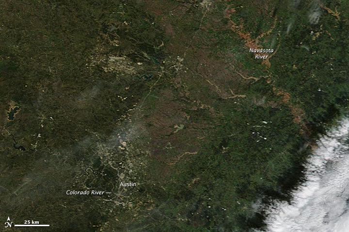
A large storm system brought more than a foot of rain to parts of Central Texas on October 30 and 31, 2013. Up to 14 inches (36 cm) of rain fell in the Austin region, according to the National Weather Service. The rain triggered flash floods that left two people dead, forced evacuations, and closed roads. The clouds had largely cleared by 12:35 p.m. when the Moderate Resolution Imaging Spectroradiometer (MODIS) on the Terra satellite acquired the top natural color image. Normally black or dark blue, rivers and reservoirs are muddy brown and green from runoff. Read more

NASA images courtesy LANCE/EOSDIS MODIS Rapid Response Team at NASA GSFC. Caption by Holli Riebeek.

NASA image courtesy Jeff Schmaltz, LANCE/EOSDIS MODIS Rapid Response Team at NASA GSFC. Caption by Holli Riebeek with interpretation by Kerry Meyer.

The view shown in this image is rare: a high bank of cirrus clouds sweeps east from the Andes Mountains of South America in otherwise clear skies. Under normal circumstances, other clouds would dominate the scene.

The Moderate Resolution Imaging Spectroradiometer (MODIS) on NASA’s Terra satellite acquired the image on September 20, 2013, when strong upper level winds were blowing east across South America. Read more

NASA image courtesy Jeff Schmaltz, LANCE/EOSDIS MODIS Rapid Response Team at NASA GSFC. Caption by Holli Riebeek with interpretation by Kerry Meyer.

Livescience.com recently featured a Terra MODIS image of Tropical Storm Raymond off of Mexico’s Pacific coast before it erupted into a major hurricane.

Read more

NASA image courtesy NASA/GSFC/METI/ERSDAC/JAROS, and U.S./Japan ASTER Science Team. Caption by Adam Voiland.

In some areas, winds tend to blow in roughly the same general direction all year. The Grand Erg Oriental, a sprawling sea of sand dunes in the Saharan Desert, is not one of them.

The winds in northeastern Algeria tend to be complex and changing. Easterly summer winds shift in the winter, becoming westerly. Meanwhile, passing storms and local geographical features further muddle the picture. If winds came consistently from one direction, crescent-shaped barchan dunes would reign. But the dominant dune type along the southern edge of Grand Erg Oriental (shown above) are large, pyramid-shaped star dunes, which only form in areas where winds blow from multiple directions.

The image was acquired by the Advanced Spaceborne Thermal Emission and Reflection Radiometer (ASTER) on NASA’s Terra satellite on October 27, 2012. Read more

NASA image courtesy NASA/GSFC/METI/ERSDAC/JAROS, and U.S./Japan ASTER Science Team. Caption by Adam Voiland.

NASA image courtesy of the LANCE/EOSDIS MODIS Rapid Response Team at NASA GSFC. Caption by Adam Voiland.

Between October 3-5, 2013, an unusually early blizzard smothered northeastern Wyoming and western South Dakota with wet, heavy snow-not to mention rain, hail, thunderstorms, and even tornadoes. In South Dakota’s Black Hills, the storm dropped more than three feet (90 centimeters) of snow in some areas, knocking out power for about 25,000 people and killing tens of thousands of cattle. Read more

NASA image courtesy of the LANCE/EOSDIS MODIS Rapid Response Team at NASA GSFC. Caption by Adam Voiland.