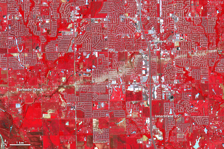
On May 20, 2013, central Oklahoma was devastated by a EF-5 tornado, the most severe on the enhanced Fujita scale. The Newcastle-Moore tornado killed at least 24 people, injured 377, and affected nearly 33,000 in some way. Early estimates suggest that more then $2 billion in damage was done to public and private property; at least 13,000 structures were destroyed or damaged. It was the deadliest tornado in the United States since an EF-5 event killed 158 people in Joplin, Missouri, in 2011. Read more
Past News
- December 2025
- October 2025
- July 2025
- May 2025
- February 2025
- November 2024
- April 2024
- February 2024
- December 2023
- October 2023
- April 2023
- February 2023
- December 2022
- October 2022
- August 2022
- July 2022
- June 2022
- April 2022
- March 2022
- October 2021
- September 2021
- August 2021
- June 2021
- May 2021
- April 2021
- March 2021
- February 2021
- January 2021
- September 2020
- August 2020
- July 2020
- April 2020
- February 2020
- January 2020
- December 2019
- November 2019
- October 2019
- September 2019
- August 2019
- April 2019
- March 2019
- November 2018
- October 2018
- August 2018
- July 2018
- June 2018
- May 2018
- November 2017
- June 2017
- August 2016
- July 2016
- June 2016
- May 2016
- April 2016
- March 2016
- February 2016
- January 2016
- December 2015
- November 2015
- October 2015
- September 2015
- August 2015
- April 2015
- February 2015
- December 2014
- November 2014
- October 2014
- September 2014
- August 2014
- May 2014
- April 2014
- March 2014
- February 2014
- January 2014
- December 2013
- November 2013
- October 2013
- September 2013
- August 2013
- July 2013
- June 2013
- May 2013
- April 2013
- March 2013
- February 2013
- January 2013
- September 2012
- June 2012
- May 2012
- April 2012
- March 2012
- February 2012
- January 2012
News By Instrument
News By Science
- Air quality
- Applications
- Atmosphere
- Carbon Cycle and Ecosystems
- Climate Variability and Change
- Data
- Earth Observatory
- Earth's Surface and Interior
- Education
- Energy Cycle
- Events
- Human Dimensions
- LAADS DAAC
- Landsat
- Orbital Changes
- Platform
- Resources
- Terra Talent Series
- Terra Visits Camp Landsat
- VIIRS
- Water Cycle
- Weather
- Wildfire
Tag: Weather
Weather News and Events
Powerhouse Fire
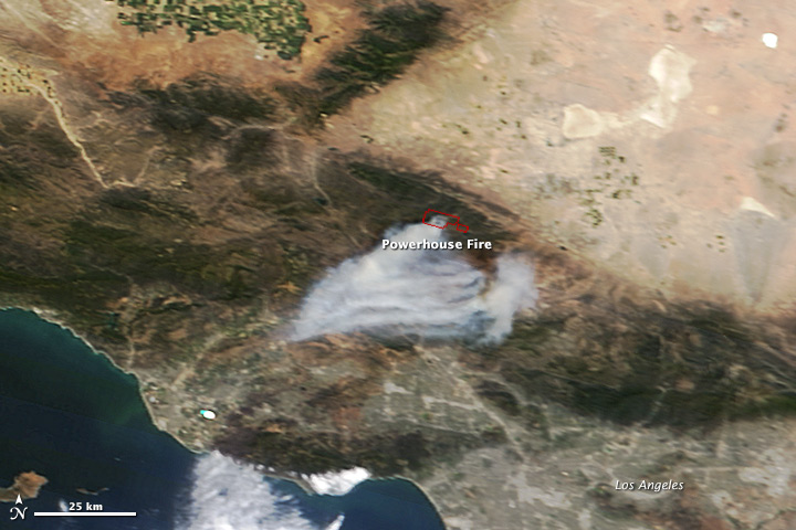
On May 31, 2013, the Moderate Resolution Imaging Spectroradiometer (MODIS) on NASA’s Terra satellite captured this image of the Powerhouse fire burning in steep terrain north of Los Angeles, California. Red outlines indicate hot spots where MODIS detected unusually warm surface temperatures associated with fires. Read more
Lingering Ice on Minnesota Lakes
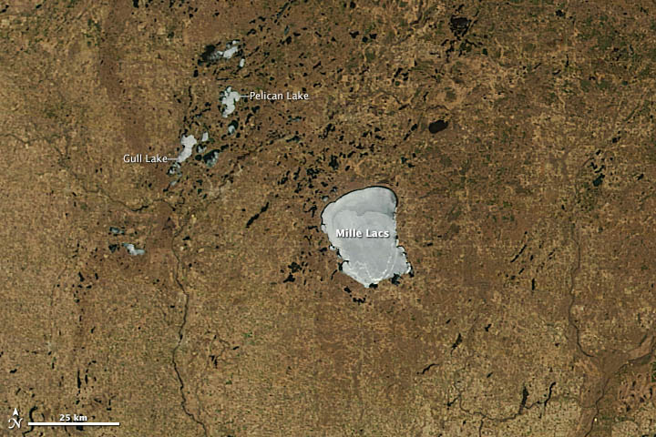
When the Moderate Resolution Imaging Spectroradiometer (MODIS) instrument on NASA’s Terra satellite passed over northern Minnesota on May 12, 2013, spring had transformed winter’s snowy white landscape into shades of green and brown. But several lakes remained stubbornly white. In 2013, unseasonably cool spring weather has left ice choking many of Minnesota’s lakes weeks longer than usual. Read more
Flooding in LaPlata
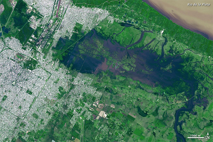
In early April 2013, severe flooding claimed more than 50 lives, and forced thousands from their homes in the Buenos Aires region, news sources said. Many of the casualties occurred in La Plata, situated about 60 kilometers (40 miles) southeast of Buenos Aires. Roughly 40 centimeters (16 inches) of rain fell on La Plata in a two-hour period April 2-3, Agence France-Presse reported.
Flood water lingered when the Advanced Spaceborne Thermal Emission and Reflection Radiometer (ASTER) on NASA’s Terra satellite captured this image on April 4, 2013. Read more
Snow in the Northeastern United States
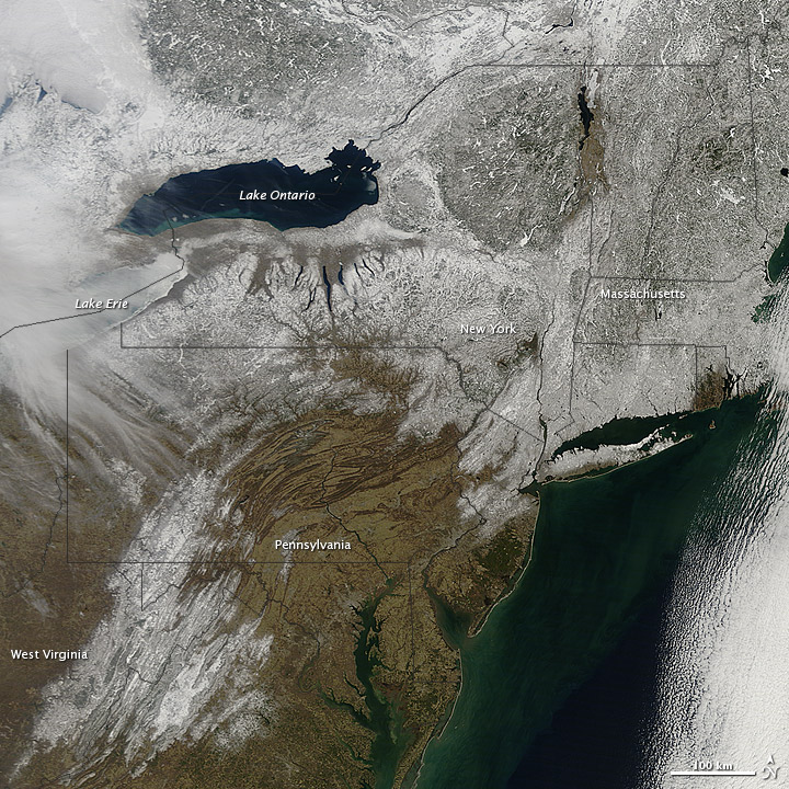
- Snow cover sprawled across the northeastern United States in early March 2013. The Moderate Resolution Imaging Spectroradiometer (MODIS) on NASA’s Terra satellite captured this natural-color image on March 9. Snow cover stretched from West Virginia into Canada, and from the western shore of Lake Ontario to the Atlantic Ocean. Read more


