Tag: Water Cycle

Water Cycle News and Events

Parana_tmo_2014162

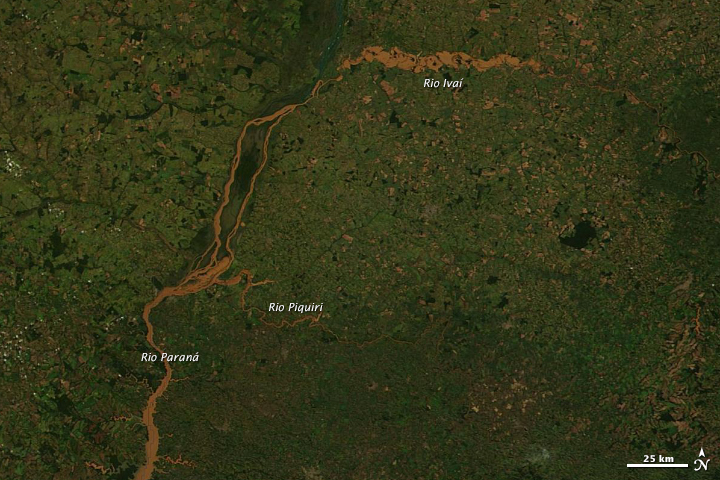
Torrential rain brought deadly floods to southern Brazil and Paraguay in June 2014. The top image, acquired by the Moderate Resolution Imaging Spectroradiometer (MODIS) on NASA’s Terra satellite on June 11, 2014, shows flooding in the Paraná River system in Brazil’s Paraná state. The Ivaí, Piquiri, and Paraná rivers are all swollen and muddy from runoff. The lower image, acquired by Terra MODIS on June 12, 2012, shows the river system in non-flood conditions. Turn on the image comparison tool to see the extent of the flooding. Read more

NASA image courtesy LANCE/EOSDIS MODIS Rapid Response Team at NASA GSFC. Caption by Holli Riebeek.

When the Moderate Resolution Imaging Spectroradiometer (MODIS) instrument on NASA’s Terra satellite passed over northern Minnesota on May 12, 2013, spring had transformed winter’s snowy white landscape into shades of green and brown. But several lakes remained stubbornly white. In 2013, unseasonably cool spring weather has left ice choking many of Minnesota’s lakes weeks longer than usual. Read more

The Caspian Sea isn’t really a sea but in fact a giant lake that spans roughly 1,000 kilometers (600 miles) from north to south. In the winter, ice often forms over the lake’s northernmost reaches, while the central and southern parts remain ice free. Temperatures are generally lower in the north, so you might guess that the ice owes its existence purely to the higher latitude. But the reality is more complex: From north to south, the Caspian Sea also exhibits differences in salinity and depth. Read more