Month: September 2015

alaska_amo_2015244
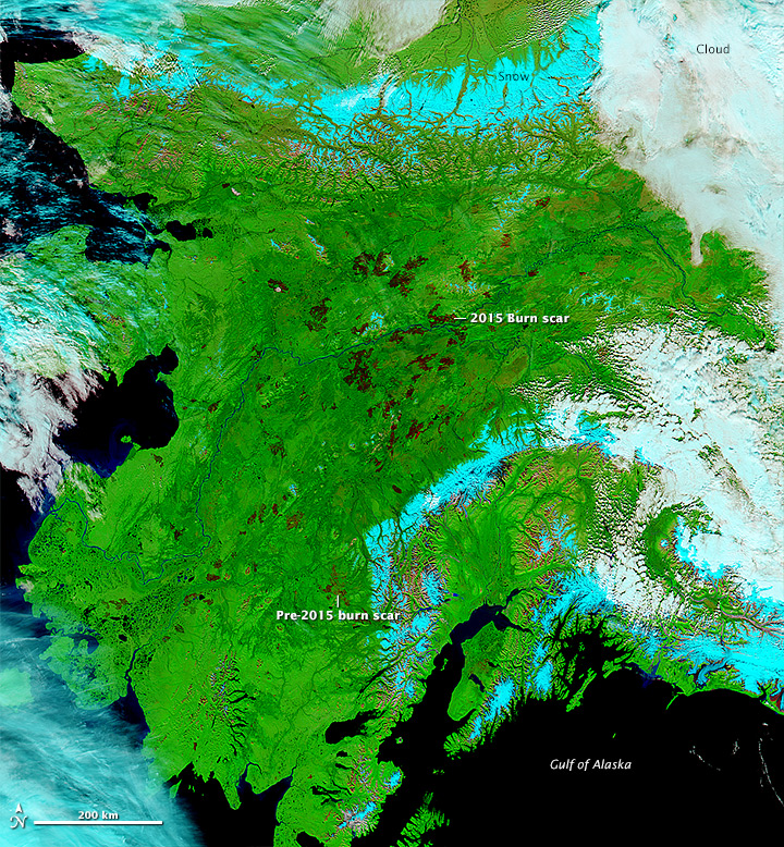
Alaska is experiencing it’s second most severe fire season since 1950 with over 5.2 million acres burned (the average is 800,000 acres per year).

Terra and Aqua Moderate Imaging Spectroradiometer (MODIS) are useful for scientists and land managers to be able to monitor and asses the environmental impact of remote forest fires.  This allows groups like the scientists from Universtity of California, Irvine, and Woods Hole Research Center to publish and analysis of carbon emissions for Alaska’s boreal forests. In addition land managing agencies are able to monitor fires unpopulated areas and allow them to burn, freeing up limited resources to be used in highly populated areas.


Read more on NASA’s Earth Observatory

denali_oli_2015166_renderMount Denali received not only a new name on August 30, 2015, it also received a new elevation.  Using the Global Digital Elevation Model (GDEM) product from the Advanced Spaceborne Thermal Emission and Reflection Radiometer (ASTER) data, the listed elevation for Moutn Denali went from 20,320 feet to 20,310 feet. The reduction in elevation was due to a more detailed global elevation survey made possible with the high resolution data from ASTER in the GDEM.  Better technology led to a more accurate elevation.

Read more on NASA’s Earth Observatory

Read the Press Release from USGS

fred_amo_2015243Hurricane Fred is the first to hit Cabo Verde since 1892. The storm caused flash flooding and wind damage.

The Moderate Resolution Imaging Spectroradiometer (MODIS) on Terra  acquired this natural-color image of Fred off the west coast Africa at 11:15 a.m. on August 31, 2015 Cabo Verde time, when the storm was at it’s peak  Wind speeds reached 75 knots.

The MODIS instrument on Terra also captured images on September 1st as Fred weakened, becoming a tropical storm.

Read more on NASA’s Earth Observatory.

PacificOcean_amo_2015208 A scientist, Yi-Chun (Jean) Chen, at NASA’s Jet Propulsion Laboratory, and his colleagues were able to show how open-cell versus closed cell clouds affect the brightness, or albedo, of ship tracks.

Using data from MODIS on-board both Aqua and Terra and from the Multi-angle Imaging SpectroRadiometer (MISR) on Terra, the team studied the relationship between ship-emitted aerosols and cloud properties. The results suggested that aerosol plumes increased the amount of clouds and albedo in open-cell formation areas; where as, areas with closed-cells were less susceptible to aerosol plumes.

Research available in the April 2015 Journal of Geophysical Research

Read more on NASA’s Earth Observatory