Category: News and Events

News and Events

NASA image courtesy NASA/GSFC/METI/ERSDAC/JAROS, and U.S./Japan ASTER Science Team. Caption by Adam Voiland.

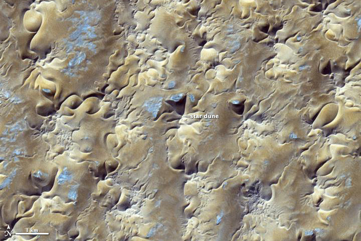
In some areas, winds tend to blow in roughly the same general direction all year. The Grand Erg Oriental, a sprawling sea of sand dunes in the Saharan Desert, is not one of them.

The winds in northeastern Algeria tend to be complex and changing. Easterly summer winds shift in the winter, becoming westerly. Meanwhile, passing storms and local geographical features further muddle the picture. If winds came consistently from one direction, crescent-shaped barchan dunes would reign. But the dominant dune type along the southern edge of Grand Erg Oriental (shown above) are large, pyramid-shaped star dunes, which only form in areas where winds blow from multiple directions.

The image was acquired by the Advanced Spaceborne Thermal Emission and Reflection Radiometer (ASTER) on NASA’s Terra satellite on October 27, 2012. Read more

NASA image courtesy NASA/GSFC/METI/ERSDAC/JAROS, and U.S./Japan ASTER Science Team. Caption by Adam Voiland.

NASA image courtesy of the LANCE/EOSDIS MODIS Rapid Response Team at NASA GSFC. Caption by Adam Voiland.

Between October 3-5, 2013, an unusually early blizzard smothered northeastern Wyoming and western South Dakota with wet, heavy snow-not to mention rain, hail, thunderstorms, and even tornadoes. In South Dakota’s Black Hills, the storm dropped more than three feet (90 centimeters) of snow in some areas, knocking out power for about 25,000 people and killing tens of thousands of cattle. Read more

NASA image courtesy of the LANCE/EOSDIS MODIS Rapid Response Team at NASA GSFC. Caption by Adam Voiland.

Posted on September 19, 2013 by Sciencecodex.com

The MODIS instrument, or Moderate Resolution Imaging Spectroradiometer aboard NASA’s Terra satellite captured an amazing image of Typhoon Usagi on Sept. 19 at 02:25 UTC moving near the Philippines. Read more

Posted on September 18, 2013 by Sciencecodex.com

When NASA’s Terra satellite passed over Tropical Storm Humberto on Sept. 17, the MODIS instrument aboard took a picture of the storm and it resembled the letter “A” as it moves through the northeastern Atlantic Ocean. Read more

With 9,330 kilometers (5,800 miles) of coastline surrounded by warm tropical and subtropical waters, Mexico is no stranger to tropical storms. But on September 15-16, 2013, the country experienced a rare double strike as two storms moved ashore simultaneously, one from the Pacific and one from the Atlantic. The last time such an event occurred was 1958, reported the Weather Channel. Tropical Storm Manuel came ashore on the Pacific coast near Manzanillo on the afternoon of September 15. Hurricane Ingrid followed suit from the Atlantic on September 16.

The Moderate Resolution Imaging Spectroradiometer (MODIS) on NASA’s Terra satellite acquired this image of the two storms on the morning of September 15. At the time, Manuel, left, was a tropical storm with winds of 55 knots (102 km/hr or 63 miles per hour). Ingrid, right, was a Category 1 hurricane with winds of 65 knots (120 km/hr or 75 mi/hr). Read more