Author: Tassia Owen

PIA20888_fig1

NASA  Image from NASA/GSFC/LaRC/JPL-Caltech, MISR Team. Originally posted on JPL’s photojournal.

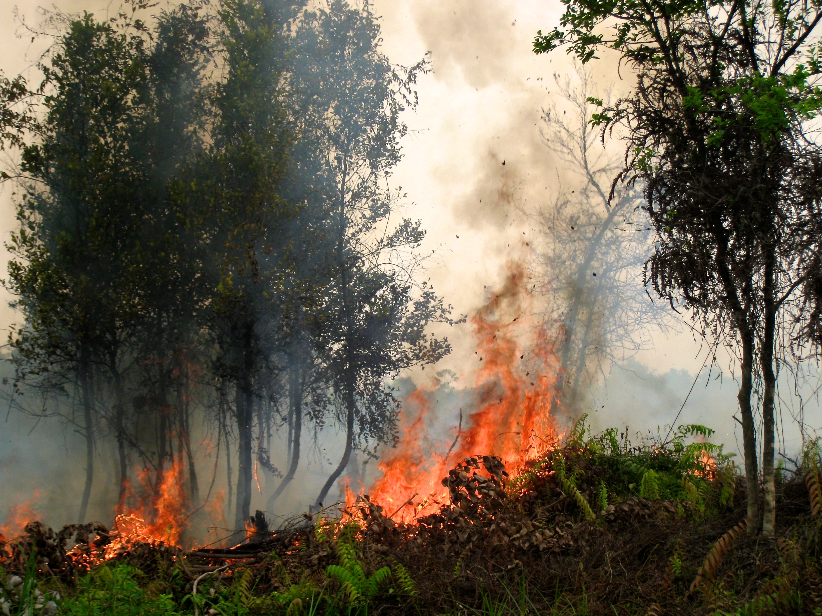
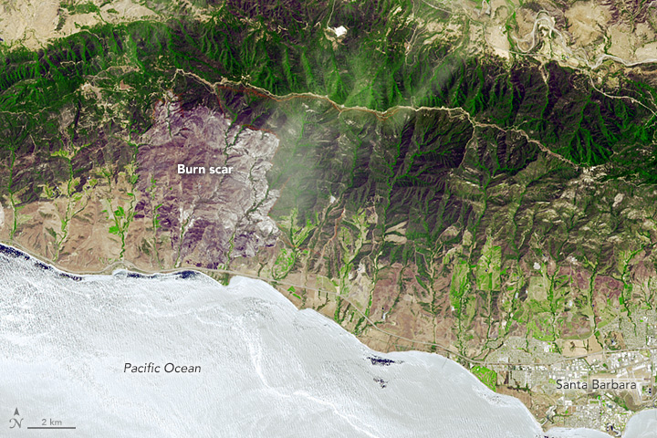
On Aug. 16, 2016, at around 10:30 a.m., a brush fire ignited in the Cajon Pass east of Los Angeles, just to the west of Interstate 15. Within a matter of hours, extreme temperatures, high winds and low humidity allowed the fire to spread rapidly, burning through brush left tinder-dry by years of drought. Firefighters quickly responded, ordering the evacuation of about 83,000 people in and around the Cajon Pass, Wrightwood, Lytle Creek, Oak Hills and surrounding areas. An as-yet uncounted number of homes and structures have burned, and Interstate 15 remains closed to downed power lines and barrier damage. By Aug. 17, the fire had expanded to more than 30,000 acres and remains zero percent contained as some 1,300 firefighters continue to battle to save homes and evacuate residents.

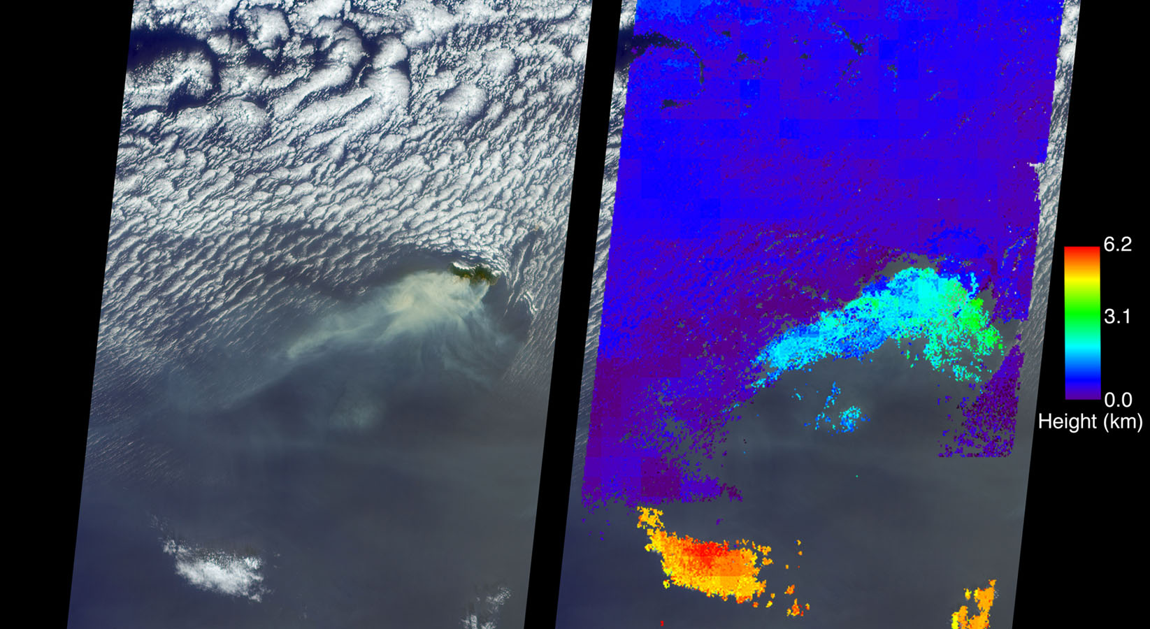
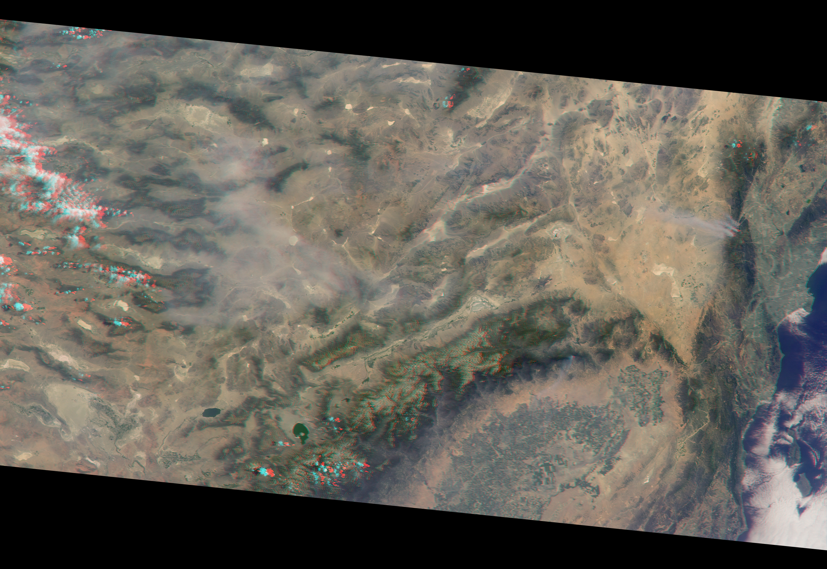
The Multi-angle Imaging SpectroRadiometer (MISR) instrument aboard NASA’s Terra satellite passed over the region on Aug. 17 around 11:50 a.m. PDT and captured this natural-color image from MISR’s 70-degree forward-viewing camera, which covers an areas about 257 miles (414 kilometers) wide. The oblique view angle makes the smoke more apparent than it would be in a more conventional vertical view. The Los Angeles metropolitan area is the large gray area on the coast in the center of the image. Three plumes from the Blue Cut Fire are clearly visible in the mountains to the north. This oblique view also shows an enormous cloud of smoke spreading northeastward over a significant portion of eastern California and Nevada. This smoke probably originated from the fire as it consumed almost 20,000 acres on the evening of the 16th and traveled north overnight.

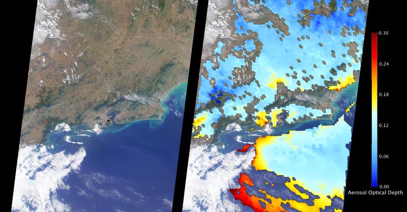
Also visible from this oblique view is considerable haziness filling California’s Central Valley, to the northwest of the Blue Cut Fire. This haziness is most likely due to smoke from several other fires burning in California, including the Soberanes Fire near Monterey, the Clayton Fire that has destroyed 175 structures north of San Francisco, the Chimney Fire and the Cedar Fire, which is visible in the image in the southern Sierra Nevada. The total number of acres burned in California this year has tripled in just the past week.

Palangkaraya, Central Kalimantan, Indonesia, September 2011. Photo by Rini Sulaiman for CIFOR Center for International Forestry Research

Data from five instruments on the NASA Aura, Terra, and Aqua satellites tracked active fires, carbon monoxide, and aerosol optical depth in the atmosphere” in Indonesia. July to October was especially dry because of the 2015-16 El Niño. The abundance of dry fuel contributed to sparking a severe fire season with widespread effects on air quality. Learn about more on nasa.gov.

PIA20887_hires

The Multi-angle Imaging Spectrodiometer (MISR) instrument on NASA’s Terra satellite acquired an image of a large wildfire on the Island of Madeira, part of the autonomous region of Portugal.  Madeira’s capital city, Funchal, also caught fire, burning homes and leading to the evacuation of a thousand people. Read more on JPL’s Photojournal.

PIA20885_modest

NASA  Image from NASA/GSFC/LaRC/JPL-Caltech, MISR Team. Originally posted on JPL’s photojournal.

The Multi-angle Imaging SpectroRadiometer (MISR) instrument aboard NASA’s Terra satellite passed directly over Rio de Janeiro, Brazil, on Aug. 2, 2016, just prior to the opening of the Summer Olympic Games. On the left is an image from MISR’s nadir (downward-looking) camera; the width of the image is 235 miles (378 kilometers), and Rio de Janeiro is visible as the large gray area on the coast in the center. The black asterisk marks the location of the Maracanã Stadium in downtown, where the opening ceremonies were held.

In the weeks leading up to the Aug. 5 opening ceremonies in Rio de Janeiro, there have been reports of elevated levels of particulate matter in the region. Particulate matter refers to tiny airborne droplets or pieces of soot and dust that can end up in the lungs, comprising an all-too-common problem for many cities around the world.

MISR data are routinely used to estimate the amount of air pollution via measurements of aerosol optical depth, which is a measure of how much incoming light from the sun is blocked by particles in the atmosphere. On the right, a map of aerosol optical depth is superimposed on the image. Individual squares making up this map measure 2.7 miles (4.4 kilometers) on a side, and holes in the map occur where an aerosol amount could not be determined, such as where clouds are present. Optical depth over Rio is slightly elevated compared to its surroundings, most likely due to the presence of air pollution, with values from 0.15-0.25. For reference, an optical depth of 0.2 corresponds to light haze.

The product shown here is a prototype of a new version of the MISR aerosol product to be publicly released in the near future, and increases the spatial resolution of the aerosol information by a factor of 16 compared to the currently available product, making it possible to observe the fine details of optical depth over urban areas.

These data were captured during Terra orbit 88426. MISR was built and is managed by NASA’s Jet Propulsion Laboratory, Pasadena, California, for NASA’s Science Mission Directorate, Washington, D.C. The Terra spacecraft is managed by NASA’s Goddard Space Flight Center, Greenbelt, Maryland. The MISR data were obtained from the NASA Langley Research Center Atmospheric Science Data Center, Hampton, Virginia. JPL is a division of the California Institute of Technology in Pasadena.

timor_tmo_2016197

Cloud Streets over Timor Sea

July 24, 2016

These “streets of the sky” called cloud streets are long parallel bands of cumulus clouds. On July 15, 2016, the Moderate Resolution Imaging Spectroradiometer (MODIS) on NASA’s Terra satellite aquired these images of cloud streets off the northern coast of Australia. Read more on NASA’s Earth Observatory.


labrador_mod_2016184

Swirls of Ice in the Labrador Sea

July 21, 2016

What first appeared to be a storm wasn’t a low pressure system in the clouds, but a swirling mass of ice in the sea. The Moderate Resolution Imaging Spectroradiometer (MODIS) on NASA’s Terra and Aqua satellites acquired views of an ice eddy off the coast of Labrador, Canada, on July 2, 2016. Read more on NASA’s Earth Observatory.


gypsymoth_tmo_2016178

Caterpillars Take Bite Out of Rhode Island Forests

July 15, 2016

Gypsy moth caterpillars damaged parts of New England’s forests and the damage is extensive enough to be seen from space. The Moderate Imaging Spectroradiomenter on NASA’s Terra satellite captured images of the damage over Rhode Island, Massachussetts and Connecticut during the pests’ population boom in the summer of 2016. Read more on  NASA’s Earth Observatory.


namibia_tmo_2016178

Making Waves in the Sky off of Africa

July 14 , 2016

On June 26, 2016, the Moderate Resolution Imaging Spectroradiometer (MODIS) on NASA’s Terra satellite acquired this natural-color image of cloud gravity waves off the coast of Angola and Namibia. Learn more about this phenomenon on NASA’s Earth Observatory.


chile_tmo_2016190

Unusual Dust Off of Chile

July 12, 2016

Large amounts of dust were airborne off the west coast of South America. This is not a typical location dust events such as this one. The Moderate Resolution Imaging Spectroradiometer (MODIS) on NASA’s Terra satellite acquired this image of airborne dust off the coast of Chile, on July 8, 2016. Read more on NASA’s Earth Observatory.


sherpafire_ast_2016171

Studying the Sherpa Fire

July 2, 2016

The Sherpa fire west of Santa Barbara, California was contained before it caused damage to homes or infrastructure. However, it still charred several thousand acres as of June 29. The Advanced Spaceborne Thermal Emission and Reflection Radiometer (ASTER) on the Terra satellite acquired an image of the burn scar on June 19, 2016. Read more on NASA’s Earth Observatory.