Tag: Applications

Applications News and Events

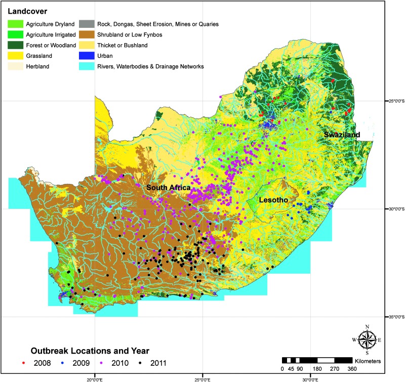
Reported Rift Valley fever (RVF) case locations in relation to Land Use/Land Cover. Image courtesy of: Margaret M. Glancey, et al., 2015; Published by Mary Ann Liebert, Inc.

Reported Rift Valley fever (RVF) case locations in relation to Land Use/Land Cover. Image courtesy of: Margaret M. Glancey, et al., 2015; Published by Mary Ann Liebert, Inc.

Moderate Imaging Spectroradiometer (MODIS) data in the Normalized Difference Vegetation Index (NDVI), an index that shows plants “greenness” or photosynthetic activity, is helping better understand risk factors associated with Rift Valley Fever outbreaks in Southern Africa.

A recent study published in the National Center for Biotechnology Information’s Pub Med looked at epidemiological and environmental risk factors from 2008 – 2011, the worst outbreak of Rift Valley fever in almost 40 years.

Periods of widespread and above-normal rainfall are associated with Rift Valley Fever outbreaks. Researchers combined data from the World Animal Health Information Database (WAHID) on what types of species were affected, where and when with environmental factors including rainfall and NDVI.

The results of the study show that these environmental factors along with geographic factors (topography, drainage, and land use) do play a role in the emergence of Rift Valley Fever.

This study will help the accuracy of future models of areas at risk, allowing more time to adequately prepare and prevent future outbreaks.

Read the full article at http://www.ncbi.nlm.nih.gov/pubmed/26273812

Shorebird populations are struggling to find wetlands on their epic migrations down the Pacific Flyway, stemming from Alaska and Canada down to South America. As water resources have decreased in the Central Valley of California due to development, agriculture and other land use changes, resting and feeding grounds for migratory birds has decreased.

A team from Cornell Lab of Ornithology’s was able to use data from the Moderate Imaging Spectroradiometer (MODIS) on-board NASA’s Terra and Aqua satellites, along with data from Landsat to identify areas that could be turned into “pop-up habitats,” where rice fields could be flooded to provide temporary habitats for migrating birds for a couple weeks per year.

To identify areas that would be beneficial “pop-up habitats,” satellite data on the location and timing of surface water was matched with migration patterns of shorebirds collected from the eBird program, a citizen science bird watching program that collects data on bird sightings. The result is the BirdReturns program, a partnership between the Nature Conservancy and the California Rice Commission that compensates rice farmers to flood their rice fields at particular times to provide migratory habitat for shorebirds.

Efforts like this can help land managers better allocate valuable resources, such as water in California, where they are needed when competition for these resources are high.

Read more on NASA.gov

Student winners of NASA’s 2014 educational “REEL Science Communication Contest” have completed their follow-on Earth science videos after a month-long workshop with NASA scientists and communication experts.

In May of 2014, NASA Earth science missions at NASA’s Goddard Space Flight Center in Greenbelt, Maryland, selected winners of their second annual video contest for high school students. The student winners each produced two-minute videos that communicate NASA Earth science to engage younger students. Winners were awarded the opportunity to work remotely with NASA experts to create new Earth science videos for NASA outreach.

Throughout July, contest winners Lena Korkeila from Placerville, California; Anna and Geof Olson from Santa Cruz, California; and Heather Forster, Sofia Bialkowski and Suzie Petryk from Huntington, New York, learned about NASA Earth science missions, communication efforts and video production.  Working with people from the Terra, Aqua and ICESat-2 Earth science missions and Goddard’s Office of Communications, the students pitched video ideas, wrote their scripts, identified NASA footage and visualizations, found or created accompanying music and recorded their narrations. Read more

Terra, among a  satellites  from many nations, joined the effort in the search for Malaysian Airlines Flight MH-370. Read more

This article from IEEE  talks about how satellite data can predict agricultural output and famine.  Terra plays a large role in measuring the National Data Vegetation Index (NDVI), which is measured using spectral bands 1 and 2 (infrared to visible light) of the Moderate-resolution Imaging Spectroradiometer. NDVI compares the amount of light reflected in near-infrared with that reflected in visible light; if there is more infrared, the vegetation in that spot is likely to be dense and thus yield more of the crop.” Armed with this information and data from other satellites researchers are able to get a better picture of how the worlds crops are faring.  Read more