

Measurement of Pollution in the Troposphere
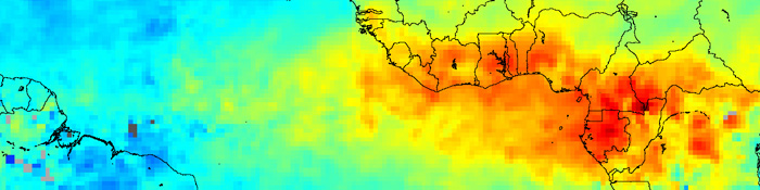
Widespread fires in western Africa release carbon monoxide into the atmosphere (red) in February 2004.
Measurement of Pollution in the Troposphere (MOPITT) is an instrument designed to enhance our knowledge of the lower atmosphere and to observe how it interacts with the land and ocean biospheres. MOPITT’s specific focus is on the distribution, transport, sources, and sinks of carbon monoxide in the troposphere. Carbon monoxide, which is expelled from factories, cars, and forest fires, hinders the atmosphere’s natural ability to rid itself of harmful pollutants.
MOPITT is one of the earliest satellite sensors to use gas correlation spectroscopy. The sensor measures emitted and reflected radiance from the Earth in three spectral bands. As this light enters the sensor, it passes along two different paths through onboard containers of carbon monoxide. The different paths absorb different amounts of energy, leading to small differences in the resulting signals that correlate with the presence of these gases in the atmosphere.
MOPITT’s spatial resolution is 22 km at nadir and it ‘sees’ the Earth in swaths that are 640 km wide. Moreover, it can measure the concentrations of carbon monoxide in 5-km layers down a vertical column of atmosphere, to help scientists track the gas back to its sources.
MOPITT web site at the University of Toronto
MOPITT web site at the National Center for Atmospheric Research