Month: January 2014

NASA image by Holli Riebeek and courtesy LANCE/EOSDIS MODIS Rapid Response Team at NASA GSFC. Caption by Michael Carlowicz.

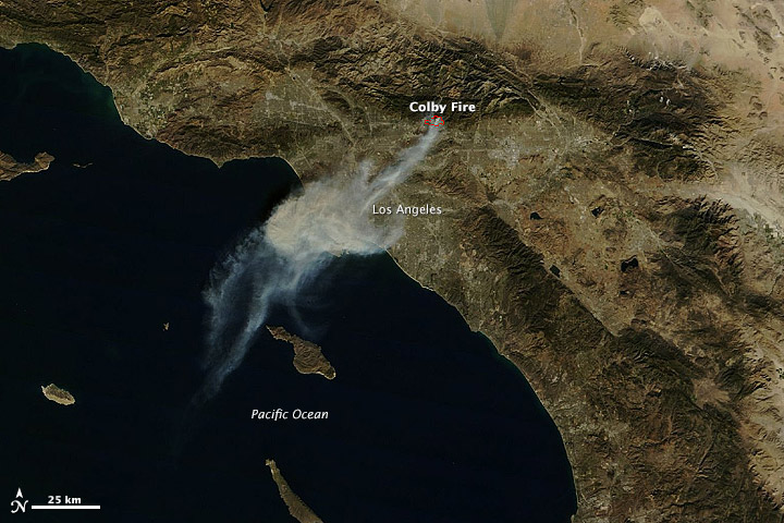
A wildfire started and spread quickly in the foothills northeast of Los Angeles on January 16, 2014. The plume of ash and smoke blanketed much of the metropolitan area and prompted air quality warnings.

The Moderate Resolution Imaging Spectroradiometer (MODIS) on NASA’s Terra and Aqua satellites captured these images of the Colby fire just before (top) and just after noon on January 16. The morning image is clearer because the scene was centered under the satellite, while the afternoon image is fuzzy because the satellite was observing from an angle. Read more

NASA image by Holli Riebeek and courtesy LANCE/EOSDIS MODIS Rapid Response Team at NASA GSFC. Caption by Michael Carlowicz.

NASA Earth Observatory image by Jesse Allen and Robert Simmon, using data from NASA/GSFC/METI/ERSDAC/JAROS, and U.S./Japan ASTER Science Team. Caption by Adam Voiland.

Though a small nation, Kuwait has an outsized role in oil production. The country has an estimated 94 billion barrels of proven oil reserves, about 9 percent of the world’s total. The oldest and largest of Kuwait’s oil fields-the Greater Burgan field in southeastern Kuwait-produces about 1.6 million barrels of oil a day.

The Greater Burgan is comprised of three smaller fields: Burgan, Magwa, and Ahmadi. The first oil well was installed in Burgan in 1938. Oil was discovered at the Magwa field in 1950 and at the Ahmadi field in 1952. The Advanced Spaceborne Thermal Emission and Reflection Radiometer (ASTER) on NASA’s Terra satellite captured this image of a portion of the Burgan field on September 27, 2009. Read more

NASA Earth Observatory image by Jesse Allen and Robert Simmon, using data from NASA/GSFC/METI/ERSDAC/JAROS, and U.S./Japan ASTER Science Team. Caption by Adam Voiland.

NASA images courtesy LANCE/EOSDIS MODIS Rapid Response Team at NASA GSFC. Caption by Holli Riebeek.

Individual deciduous trees mark the turning of the seasons with pale buds in the spring, densely packed green leaves in summer, vibrant red, orange, or yellow tones in fall, and bare branches in the cold of winter. Forests also mark the changes, but on a grander scale. In this series of images from the Moderate Resolution Imaging Spectroradiometer (MODIS) on NASA’s Terra satellite, forests mark the time along the southern ridges of the Appalachian Mountains, where the states of North Carolina, Tennessee, Georgia, and South Carolina all come together. Read more

NASA images courtesy LANCE/EOSDIS MODIS Rapid Response Team at NASA GSFC. Caption by Holli Riebeek.

NASA Earth Observatory image by Jesse Allen, using data from the Level 1 and Atmospheres Active Distribution System (LAADS). Caption by Adam Voiland, with information from Paul Newman (NASA Goddard), Marshall Shepherd (University of Georgia), and John Knox (University of Georgia).

The map above shows land surface temperature anomalies in North America for January 1-7, 2014. Based on data from the Moderate Resolution Imaging Spectroradiometer (MODIS) on NASA’s Terra satellite, the map depicts temperatures for that period compared to the 2001-2010 average for the same week. Areas with warmer than average temperatures are shown in red; near-normal temperatures are white; and areas that were cooler than the base period are blue. Gray indicates areas where clouds blocked the satellite from collecting usable data. While much of the United States was experiencing frigidly cold temperature, Sochi Russia was warmer than average.  Read more

NASA Earth Observatory image by Jesse Allen, using data from the Level 1 and Atmospheres Active Distribution System (LAADS). Caption by Adam Voiland, with information from Paul Newman (NASA Goddard), Marshall Shepherd (University of Georgia), and John Knox (University of Georgia).

NASA Earth Observatory image courtesy Jeff Schmaltz LANCE/EOSDIS MODIS Rapid Response Team, GSFC. Caption by Adam Voiland.

In the midst of a cold snap that sent temperatures 20-40°F (11-22°C) below normal across much of the United States, the Moderate Resolution Imaging Spectroradiometer (MODIS) on the Terra satellite captured an image of cloud streets over the Atlantic Ocean on January 7, 2014. Read more

NASA Earth Observatory image courtesy Jeff Schmaltz LANCE/EOSDIS MODIS Rapid Response Team, GSFC. Caption by Adam Voiland.